Sidewalks: Difference between revisions
(→Examples: Explanations simplified, references added) |
Hungerburg (talk | contribs) (→Examples: Reworked, as appropriate for an overview) |
||
| Line 65: | Line 65: | ||
==Examples== |
==Examples== |
||
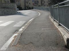
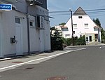
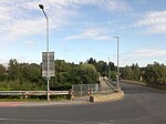
Below some pictures meant as an aid in determining, where the "sidewalk" annotation should be justified, ranging from the least controversial to conditions where, perhaps only consulting with the local administration can give an explicit ruling. |
|||
Sidewalks can be designed in such different ways that it is not always easy to clearly identify them. The correct classification is important for cyclists, for example, who are generally not allowed to ride on sidewalks. In cases of doubt, the question "Is the path part of the road" will help.<ref> Road Layout Design CD 127 Cross-sections and headrooms, https://www.standardsforhighways.co.uk/prod/attachments/66f2661f-959d-4b13-8139-92fbd491cbcf </ref><ref> Road Planning and Design Manual, Chapter 7: Cross Section, https://www.tmr.qld.gov.au/-/media/busind/techstdpubs/Road-planning-and-design/Road-planning-and-design-manual/Current-document/RPDM_Chapter7.pdf </ref> |
|||
{| class="wikitable" border="1" cellspacing="0" cellpadding="2" |
{| class="wikitable" border="1" cellspacing="0" cellpadding="2" |
||
! Sidewalk || Delimited From Its Road By … |
|||
! No || Image || Sidewalk || Note |
|||
| ⚫ | |||
| 1 |
|||
| ⚫ | |||
| Yes |
|||
| ⚫ | |||
|- |
|- |
||
| ⚫ | |||
| 2 |
|||
| ⚫ | |||
| ⚫ | |||
| Yes |
|||
| ⚫ | |||
|- |
|- |
||
| 3 |
|||
| [[Image: Gehsteig_mit_Pflasterung.jpg|150px]] |
| [[Image: Gehsteig_mit_Pflasterung.jpg|150px]] |
||
| ⚫ | |||
| Yes |
|||
| ⚫ | |||
|- |
|- |
||
| ⚫ | |||
| 4 |
|||
| ⚫ | |||
| ⚫ | |||
| Yes |
|||
| Delimited by a barrier |
|||
|- |
|- |
||
| ⚫ | |||
| 5 |
|||
| some kinds of barriers |
|||
| ⚫ | |||
| Yes |
|||
| ⚫ | |||
| ⚫ | |||
| ⚫ | |||
| ⚫ | |||
|- |
|- |
||
| 6 |
|||
| [[Image: Gehsteig_unter_Bruecke.jpg|150px]] |
| [[Image: Gehsteig_unter_Bruecke.jpg|150px]] |
||
| a wider green strip, structurally motivated |
|||
| Yes |
|||
| Delimited by a functionally determined, wider green strip |
|||
|- style="background-color:#fae5d3;" |
|||
| 7 |
|||
| [[Image: Begleitweg_am_Boeschungsfuss.jpg|150px]] |
|||
| No |
|||
| The parallel path is separated from the main road by an embankment |
|||
|- style="background-color:#fae5d3;" |
|||
| 8 |
|||
| [[Image: Begleitweg_an_Boeschungskante.jpg|150px]] |
|||
| No |
|||
| The parallel path is separated from the main road by a ditch |
|||
|} |
|} |
||
Revision as of 22:12, 16 November 2020

|
| Description |
| Sidewalks (also footways, footpaths or pavements) are provided beside the carriageway of a highway for use by pedestrians and sometimes also cyclists. |
| Tags |
The ![]() sidewalk (or pavement) is that part of a highway set aside for the use of pedestrians and sometimes also cyclists, separated from the
sidewalk (or pavement) is that part of a highway set aside for the use of pedestrians and sometimes also cyclists, separated from the ![]() carriageway (or roadway). A sidewalk may be separated from the carriageway by only a
carriageway (or roadway). A sidewalk may be separated from the carriageway by only a ![]() kerb (or curb), by a
kerb (or curb), by a ![]() road verge or alternatively may be at some distance from the road (but still associated with it). It also may be separated from the road by some form of barrier, for example bushes or a line of trees. A road may have a sidewalk on only one side of the carriageway, or both side or have no sidewalks.
road verge or alternatively may be at some distance from the road (but still associated with it). It also may be separated from the road by some form of barrier, for example bushes or a line of trees. A road may have a sidewalk on only one side of the carriageway, or both side or have no sidewalks.
Terminology
Caution over use of terms:
The legal UK term for a pavement or a sidewalk is footway. However, the term footway is used within OSM for any path, be it beside a carriageway or otherwise. The term pavement which is often used in the UK as an alternative to footway is used in the USA for the surface of the carriageway (which incidentally is known as a roadway in the USA!)
So because footway and pavement, the British English alternatives, are open to confusion, the North American English sidewalk is used in this case even though British English is the preferred language for OSM tagging and wiki.
How to map
The inclusion of sidewalk information makes it easier to provide effective pedestrian routing, and in particular good narrative descriptions of pedestrian routes along motorised roads.
Sidewalk as refinement to a highway
The simplest method is to tag the associated highway with sidewalk=both/left/right/no (none is also used synonymously to no) as appropriate for those sections of sidewalk that are parallel with the carriageway and to use highway=footway where the path diverges from the carriageway. Designations of 'left' and 'right' are relative to the direction of the way.
Attributes of sidewalks are sometimes added as further tags on the highway, for example:
This mapping method is not providing information about geometry of sidewalk itself (including lack of information how far from highway=* line representing center of road sidewalk is located). On the other hand it makes possible to easily check whatever given road has sidewalks.
Note that it is extremely hard to correctly render place where a pedestrian route diverges from highway where it was mapped using sidewalk tag.
If sidewalk tags on the highway are used instead, free crossing across road at any location may be very easily implemented in routing programs. This function is desirable by many people, and is significantly more complicated to achieve for places where sidewalks are tagged as separate ways. Conversely, it is recommended to represent the sidewalk as a separate way, if the sidewalk is not just attached with a kerb but separated by a road verge or other barriers, to prevent routers from assuming free crossing.
Access information for pedestrians
The above tagging provides information about the physical infrastructure rather than legal access details which can be included using foot=yes/no. The assumption is that all roads are legally accessible to pedestrians except for highway=motorway where it is assumed that pedestrians are not allowed unless otherwise stated.
Sidewalk as separate way
A different approach is to map each sidewalk as separate ways using highway=footway. Use footway=crossing for places where the footway crosses a street. Use footway=sidewalk where the footway runs more or less along the street, which is a hint for renderers that may be used for special handling of sidewalks. The corresponding highway can also be tagged with sidewalk=separate.
This method allows for a more spatially accurate representation of the pedestrian environment. In addition, it allows a more straightforward use of barrier=*, tactile_paving=*, kerb=*, surface=*.
The method produces a visible result in existing routing engines and renderers, as they will usually treat it the same manner as footways that are not associated with a road, unlike footway=sidewalk tag that is rarely displayed on maps. It has number of consequences, some desirable, some undesirable, depending on many factors. Footways represented as separate objects for some are desirable as map is more detailed and readable at high zoom. On the other hand on lower zoom this approach tends to produce a more cluttered map and occasionally other undesirable effects.
Some mappers add name tags copying the name of the street to separately mapped sidewalks. There is no consensus on whether this is a good idea or a bad idea, and regional customs differ.
Crossing only on explicitly marked crossings may be sometimes desirable, examples including wheelchair users, countries where pedestrians may not cross roads at any location legally, people who anyway prefer cross roads at explicit crossings. But sometimes people would prefer to allow crossing smaller roads at any point along the road. If you wanted to build a (non barrier-free) router that enforces that then you would need more sophisticated processing.
Cycleway and footway on sidewalk
In some cases sidewalk is also a cycleway. In such situations following methods are used
- tagging it highway=path + bicycle=designated + foot=designated + segregated=*
- for segregated cycleway/footway some people map them separately - part for pedestrian as highway=footway and part for cyclists as highway=cycleway
Regional variations
In some regions one of these tagging schemes is clearly more popular than other. In such case it is strongly preferable to continue mapping using established method. For example in Warszawa, Poland large part of sidewalks are mapped using separate way scheme, without copying road names. Changing this would require massive amount of work and would be unlikely to be considered as a good idea by local mappers[1]. In place where majority sidewalks is mapped using tags on roads one should not start mapping footways as a separate ways without consultation with a local community.
History
In the early days of openstreetmap, there was no specific method to map sidewalks. Actually, there was no method to map ways for pedestrian use at all. This deficiency got remedied by popular usage of the highway=footway tag. Its wiki article dates back to January 2008. There was still no method to specifically map sidewalks then, though footways sometimes got used to this effect, especially, where they were physically distinct features on ground.
Beginning some time in 2008[2], people started annotating streets with sidewalk=* tags, especially so, where sidewalks were perceived to be physically indistinct features on ground, thereby following the "One feature, one OSM element" good practice principle. Again by popular usage, this "refinement of the highway" approach became a first method, to specifically have that information in the openstreetmap database.
Continued extensive mapping of separate footways alongside of roads and streets, in 2011 prompted the "refinement of the footway" approach[3], by annotating such ways with a footway=sidewalk key. Although conceptually quite different, from the point of view of the objective, this tool made both methods informationally roughly equivalent, so historically it became known as the "separate way" approach of mapping sidewalks.
Examples
Below some pictures meant as an aid in determining, where the "sidewalk" annotation should be justified, ranging from the least controversial to conditions where, perhaps only consulting with the local administration can give an explicit ruling.
| Sidewalk | Delimited From Its Road By … |
|---|---|

|
a floor marking |

|
a different paving / curb |

|
a row of trees |

|
some kinds of barriers |

|
a narrow green strip / verge |

|
a wider green strip, structurally motivated |
Presentation

- A MapCSS stylesheet is available for JOSM.
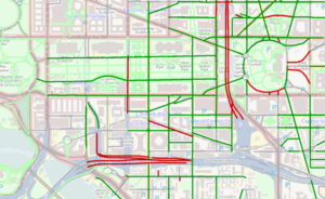
- OpenStreetMap detailed overlays generates a road overlay with lanes, cycleways, parking, and sidewalks rendered at higher zooms (16+). A slippy map version is available online.
References
See also
- Guidelines for pedestrian navigation
- Bicycle: similar concepts for cycleways
Further reading
- "Improving sidewalks globally in OpenStreetMap", MapBox Blog posting by Tim Channell, 27 October 2015
| ||||||||||||||||||||||||||||||