Ca:OsmAnd
| OsmAnd | |
|---|---|
 | |
| Autor: | Victor Schreb & contributors |
| Llicència: | GNU General Public License (Al Market: Versió «free» amb limitacions. 5.99€ OsmAnd+ sense limitacions. La darrera versió sense limitacions pot descarregar-se des de FDroid.) |
| Plataformes: | Android, iOS, i BlackBerry OS |
| Versió: | 4.7.1 (2024-02-06) |
| Idiomes: | anglès, rus, alemany, francès, àrab, búlgar, bosnià, txec, danès, espanyol, basc, finès, hebreu, hindi, hongarès, armeni, indonesi, italià, jp, georgià, coreà, italià, letó, marathi, neerlandès, noruec, polonès, portuguès, romanès, eslovac, serbi, suec, ucraïnès, vietnamita, i xinès |
| Lloc web: | http://osmand.net |
| Codi font: | http://code.google.com/p/osmand/source/checkout |
| Llenguatges de programació: | Java i C++ |
|
Navegació, càlcul de rutes (en línia i fora de línia), visualització de mapes OSM (tessel·les i vectors, també fora de línia), cerca de PDIs i adreces (fora de línia), enviament d'errors i PDIs a OSM, preferits, informació de transports públics, etc. S'està desenvolupant de manera activa. | |
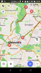
L'OsmAnd (pàgina web de l'OsmAnd) és una aplicació de navegació per Android completament oberta que es basa en els mapes d'OpenStreetMap.
Baixada i instal·lació
Existeixen tres versions de l'OsmAnd:
- OsmAnd+: 5.99€, sense limitacions;
- OsmAnd: Gratuïta, però amb limitacions;
- OsmAnd~: Gratuïta, sense limitacions (donate link), a F-Droid;
- I l'OsmAnd-default.apk el nightly build .apk (però és possible que sigui «inestable» o experimental, i no s'actualitzi automàticament)
Vegeu també la pàgina d'instal·lació oficial de l'OsmAnd.
Característiques de l'OsmAnd:
- Mostra mapes de vectors de l'OSM (*.osm.pbf, *.obf) i molts mapes de tessel·les (Mapnik, Google Maps/Satellite/Terrain, CloudMade, Cyclemap, OpenPisteMap, MapSurfer.Net, Microsoft Maps/Earth/Hybrid)
- Capes per PDIs (punts d'interès), parades de transport públic, errors d'OSM, preferits, traces de GPX i tràfic de Yandex
- Pot utilitzar mapes de vectors fora de línia i indexacions d'adreces creats amb OsmAndMapCreator
- Cerca d'adreça/PDI/localització utilitzant índex fora de línia, o bé en línia a través de Nominatim
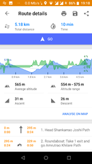
- turn-by-turn voice-guided navigation, with online routing from CloudMade, OpenRouteService, OSRM or YOURS
- La mateixa navegació fora de línia
- Zoom automàtic basat en la velocitat
- Rotació automàtica del mapa basada en la direcció del moviment o la brúixula
- Historial i preferits
- Modes preestablerts cotxe/bicicleta/vianant
- Afegeix PDIs a OpenStreetMap
Consells per utilitzar dades de mapes fora de línia:
- Els mapes fora de línia que poden utilitzar-se a OsmAnd tenen l'extensió de fitxer *.obf
- En les darreres versions d'aquests fitxers de mapa s'hi inclouen totes les dades dels mapes de vectors, així com els índex de PDIs i d'adreces per la cerca fora de línia.
- you can generate your own *.obf files by getting fresh raw OSM data for example via geofabrik.de or cloudmade.com, then process these osm files with OsmAndMapCreator (Java program for desktop PC) that is offered at Osmand's Google-website (try to get latest nightly build).
- when you have several *.obf files for single regions of a certain country, you can combine them with inspector.bat or inspector.sh that is delivered with OsmAndMapCreator. Start this script on a command line without any parameters to see all options and proceed.
- Maybe there is a named street in the OSM data, but OsmAnd cannot find it via its offline address search? Run the above mentioned inspector with parameter -v and [nameofyourmapfile].obf >list.txt ... this will give you a text file with all places that are within that obf file and all streets that are associated to that place. Thus you can find out whether OsmAnd's street list is incomplete (this can have several reasons like missing administrative borders etc.)
Les categories pels PDI (punts d'interès) inclouen:
- sustenance (bar, bbq, biergarten, cafe, drinking_water, fast_food, food_court, pub, restaurant)
- education (college, kindergarten, library, school, university)
- transportation (bicycle_parking, bicycle_rental, bus_station, car_rental, car_sharing, car_wash, ferry_terminal, fuel, grit_bin, parking, taxi)
- finance (atm, bank, bureau_de_change)
- healthcare (baby_batch, dentist, doctors, first_aid, hospital, pharmacy, veterinary)
- entertainment (architect_office, arts_centre, brothel, cinema, community_center, fountain, nightclub, sauna, stripclub, studio, theatre)
- tourism (alpine_hut, artwork, attraction, camp_site, caravan_site, chalet, guest_house, hostel, hotel, information, motel, museum, picnic_site, theme_park, viewpoint, zoo)
- historic (archaeological_site, battlefield, boundary_stone, castle, fort, memorial, monument, ruins, wayside_cross, wayside_shrine, wreck)
- natural (bay, beach, cave_entrance, cliff, coastline, fell, glacier, heath, land, marsh, mud, peak, sand, scree, scrub, spring, stone, tree, volcano, water, wetland)
- shop (alcohol, bakery, beauty, beverages, bicycle, books, boutique, butcher, car, car_repair, charity, chemist, clothes, computer, confectionery, department_store, doityourself, dry_cleaning, electronics, fabrics, farm, florist, funeral_directors, furniture, garden_centre, general, gift, glaziery, greengrocer, hairdresser, hardware, hearing_aids, hifi, ice_cream, jewelry, kiosk, laundry, mall, massage, money_lender, motorcycle, newsagent, optician, organic, outdoor, pawnbroker, second_hand, shoes, sports, stationary, supermarket, tattoo, toys, travel_agency, variety_store, video)
- leisure (common, dance, dog_park, fishing, garden, golf_course, ice_rink, nature_reserve, marina, miniature_golf, park, pitch, playground, sports_centre, slipway, stadium, track, water_park)
- sport (10pin, archery, athletics, australian_football, baseball, basketball, beachvolleyball, boules, bowls, canoe, chess, climbing, cricket, cricket_nets, croquet, cycling, diving, dog_racing, equestrian, football, golf, gymnastics, hockey, horse_racing, ice_stock, korfball, motor, multi, orienteering, paddle_tennis, paragliding, pelota, racquet, rowing, rugby, shooting, skateboard, skating, skiing, soccer, swimming, table_tennis, team_handball, tennis, toboggan, volleyball)
- other (bench, clock, courthouse, crematorium, embassy, emergency_phone, fire_hydrant, fire_station, grave_yard, hunting_stand, internet_access, marketplace, place_of_worship, police, post_box, post_office, prison, public_building, recycling, shelter, telephone, toilets, townhall, vending_machine, waste_basket, waste_disposal)
Addició de PDIs i adreces
OsmAnd can be set to upload points of interest offline or online. If it is set up for offline, the pois have to be manually uploaded. Otherwise they are uploaded instantly to the OSM database.
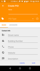
Afegiu un PDI (punt d'interès)
- Feu clic a la localització del mapa on voleu que aparegui el PDI
- Feu clic a la caixa de localització de color gris
- Seleccioneu «Crea un PDI»
- Escriviu la informació a cadascun dels camps. L'altre caixa automàticament afegeix la clau per cada valor seleccionat.
- El procediment per afegir una adreça és encara farragós però pot realitzar-se.
- Seleccioneu el «Mode avançat»
- Seleccioneu «Afegeix etiqueta»
- Escriviu «A» a la caixa de l'etiqueta. No podreu veure el camp complet, per tant haureu de recordar en quin lloc va cada valor.
- Escriviu-hi el valor dins
- Feu clic a envia
- OsmAnd
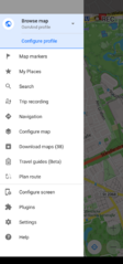
Menú principal
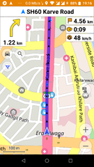
Navegació per cotxe
Direccions de navegació
Escull/crea un filtre PDI (fora de línia)
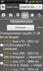
Cerca de transport
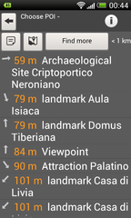
Cerca de PDIs més propers (fora de línia)

Realització d'una cerca per l'adreça (fora de línia)
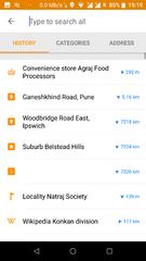
Cerca a l'historial
Mode vianant
Mostra/edita errors a OSM
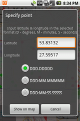
Mostra/vés a les coordenades
Mostra/edita PDIs/transports sobre el mapa
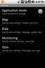
Configuració

Target menu


Personalització de l'OsmAnd
Creació dels teus propis mapes
Vegeu OsmAndMapCreator
Definició del teu propi estil de renderització
Comenceu amb el fitxer preestablert de renderitzat: https://github.com/osmandapp/Osmand/blob/master/DataExtractionOSM/src/net/osmand/render/default.render.xml
Editeu el fitxer com desitgeu i situeu-lo al vostre dispositiu a la carpeta osmand/rendering
Seleccioneu la personalització del renderitzat a l'OsmAnd
Traducció al català
Vegeu-ne als detalls a la pàgina corresponent a Softcatalà.