CanVec
See Import/Guidelines and Automated Edits code of conduct for more information. Imports/automated edits which do not follow these guidelines might be reverted!
Summary
CanVec is a digital cartographic reference product produced by Natural Resources Canada (NRCan). CanVec originates from the best available data sources covering Canadian territory and offers quality topographic information in vector format that complies with international geomatics standards.
CanVec is a multi-source product derived from the former National Topographic Data Base (NTDB) and GeoBase initiative datasets (www.geobase.ca). CanVec product contains more than 90 topographic entities organized into 11 themes.
Natural Resource Canada supports the work done by the Canadian OpenStreetMap Community by offering an .osm version of its CanVec product. This product can be uploaded in OpenStreetMap database using Potlatch, JOSM, Merkaator or other editing tools.
Import Warnings
Many experienced OSM users have inadvertently broken parts of the map while importing CanVec data. If you are going to import data from the NRCAN .OSM files, please try to keep the following in mind
- Do not try to import changes to the coastline or large lakes unless you have substantial experience both editing coastlines and importing CanVec data. You should have a good understanding of how coastlines are rendered and tagged.
- Avoid importing duplicate features. In the past many people have added features (roads, forests, lakes, etc.) on top of an existing data for the same physical object. Other people have imported CanVec files on top of an earlier less complete CanVec import resulting in duplicate features. Don't do this. Check every object you import to avoid duplicating an existing object
- Monitor keepright after your import so you can find, and fix errors introduced by your import.
- Monitor Osmose after your import so you can find, and fix errors introduced by your import.
See below the section § CanVec product - Datasets to find the files.
CanVec product - OSM format
- The geometric model is described in the page below
- The entities tagging is described in the corresponding pages below
- CanVec: Buildings and structures (BS)
- CanVec: Energy (EN)
- CanVec: Relief and landforms (FO)
- CanVec: Hydrography (HD)
- CanVec: Industrial and commercial areas (IC)
- CanVec: Administrative boundaries (LI)
- CanVec: Places of interest (LX)
- CanVec: Water saturated soils (SS)
- CanVec: Toponymy (TO)
- CanVec: Transportation (TR) - Roads and railways (airport, ferry)
- CanVec: Vegetation (VE)
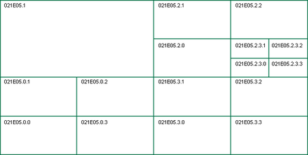
The product is tiled based on National Topographic System (NTS) map sheets—see Canada NTS Tile System. Each map sheet is sub tiled using a quadtree algorithm. Subtree naming convention is SW=0, NW=1, NE=2, SE=3. A tile is split when there are more than 25K nodes in it. Each tile is a separate .osm file. All files are zipped together.
- A Metadata file is provided with each map sheet and zipped with .osm files. It provides information on accuracy and correctness of included data. The content is described in the page below.
- A fixme file is provided, when available, with each map sheet and zipped with .osm files. It provides significant differences between OSM and the CanVec product. It is a helpful information that can help the community to keep OSM database up to date. The content of the fixme files is described in the page below.
CanVec product - Datasets
The CanVec.osm datasets are available from the NRCAN ftp http://ftp.maps.canada.ca/pub/nrcan_rncan/vector/osm/.
Available datasets are classified using their National Topographic System (NTS) number. To find the NTS number of an area of interest:
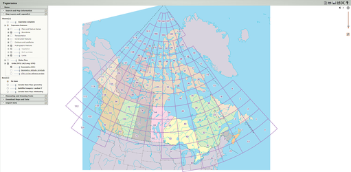
- Go to this NRCan website (Toporama).
- A map of Canada will be displayed. Toggle the NTS Grid icon from the menu to make the NTS grid visible (the grey icon next to the map scale).
- Zoom-in the area of interest and the NTS number will eventually appear. An area included in the NTS number 21e5 will be found in the file 021E05.zip.
These datasets are provided to the community under the standard CanVec Product Licence.
Import process
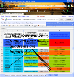
To keep track of what is going on with CanVec Import. Tiles that are being imported by an OSM contributor are identified in google docs chart, as 'Work in Progress' / planning / complete.
If you wish to import CanVec tiles to a "white space" in OSM, just look at the chart.
- If it is listed as "Work in progress", choose another one.
- If not, register the CanVec tile name in the list below and start to import.
- Add in more rows to the chart as needed.
- When finished all four quadrants of an area, remove the extra three rows so to just have one row indicating the larger tile name.
Please see the CanVec Import Status Google Doc's chart for details of the progress. The chart is open to Public Access, and it maintained by User:Acrosscanadatrails. It is requested to sign in with a username (so then others know who is working on the chart). If you would like editing access, please just ask the talk-ca list, or #osm-ca IRC chat.
- Of course, everyone is free to use it or not. :-)
- Use the various Canada WMS Layers (Toporama, GeoBaseNHN and NTS tile view and Mapnik slippy map to easily compare features to be able to trace when needed.
- Stay connected on the talk-ca discussion list, the community is happy to help.
- Stay connected on the #osm-ca IRC, the more people online, the easier it is to get your questions answered.
- This is the Google Docs chart showing all the features with its current status. (if approved by the community) (external to the above wiki charts) (The Wiki Chart is more current as of Acrosscanadatrails 01:53, 24 April 2010 (UTC)).
Data issues
- Overlapping ways of lakes over the hole of a forest multipolygon.
- Waterways like streams and rivers are disconnected at tile edges.
- Natural areas like glaciers, wetlands and lakes are disconnected at tile edges.
Screencasts of CanVec imports
In this series of videos, I go through the process of importing CanVec, from the simple situations up to the more complex. I assume that the user has basic working knowledge of JOSM (e.g., they have several hours of basic node/way/relation editing).
- Introduction to NTS tiling and how to download a tile.
- A simple CanVec import into an empty area of OSM. I forgot to mention in the video that when you are in the upload window, you should go to the "Advanced" tab, and make sure you are set to upload data in chunks of size 5000. If you get an upload timeout error don't panic - press the upload button again without changing anything, and JOSM will attempt to pick up where it left off. The next time you upload an import, try setting the chunk size even lower, like 500 objects.
- Importing the neighboring tile to the first. Since we are importing an area next to one, we've already imported, we need to join ways and areas.
Using Potlatch
Potlatch takes a different approach, encouraging you to bring objects in one-by-one so that you review them as you go, rather than simply uploading the imported file.
- Identify the tile and download the .zip as above.
- Open Potlatch 2 for the desired area and:
- Select Background > Vector file...
- Under 'Add new vector layer', select 'OSM', then click 'File: Open...'.
- Find your .zip file and open it (it may take a while).
- When it's loaded, change the new layer from Potlatch style to another one (e.g., GPS).
- Now simply "pull through" the items you want from the background layer to the map by Alt-clicking them (shift-control-click if you're using Linux and your window manager eats Alt).
- When you've done all you want, save as usual.
CanVec versions
These are the versions of CanVec product that were converted to OSM format by Natural Resources Canada
CanVec 10
Processing started on July 12, 2012 and finished on July 24, 2012
Changes from previous release:
- There is no more "Here be Dragons" areas in the CanVec product! NRCan has just completed Canada's mapping at 50K scale.
- Municipal Boundaries for SK, MB, NB, YT, NT, and NU - linear - are available.
- Water definition: natural=water now fits with coastline definition (height water level).
- Metadata text file included with each zip file. It describes content's validity dates and accuracy.
Upload=falsetag added in the file header to warn contributors if they really want to upload it.
Known issues (not necessarily errors, but things that importers should be aware of):
- Roads in QC that are newer then Release 6 are tagged with surface=unpaved and lanes=-1.
- Roads in BC with a direction in the name (e.g. name=Cedar East) have an extra space
- highway=service in parts of BC have surface=unpaved regardless of if they are paved
CanVec 8
Processing started on August 11, 2011 and finished on September 27, 2011
Changes from previous release:
- Swapped amenity=school/amenity=prison tag values corrected
- Misspelled tag value on highway=unclassified corrected.
- Duplicated railway=rail features removed.
- Single node natural=land within natural=water inner polygon created only if a name tag is attached to it.
- Multiple consecutive spaces in name tag are removed.
- name:fr=*/name:en=* applied on all features when available.
- Surfaces orientation respect right-hand rule.
- Missing large polygons should have been corrected (to confirm).
Known issues (not necessarily errors, but things that importers should be aware of):
- Water natural=water represents permanent water and doesn't fit with coastline definition (high water level). Permanent water must be merged with intermittent water natural=water + water=intermittent to create a high water level definition. High risk of errors if used to replace natural=coastline.
CanVec 7
Processing was started on November 30, 2010 and finished on January 25, 2011.
Changes from previous release:
- Contains Manitoba street names.
- Updated road network for Quebec, including addressing.
- Updated hydrography for BC coastal areas.
- natural=land area features are no longer a duplicate of natural=water inner polygon. These are now single node point features.
- natural=peak features are now present.
- updated vegetation for some areas in eastern Canada.
- landform=beach replaced by natural=beach for rendering reasons.
- Areas that were tagged aeroway=runway in previous release are now tagged aeroway=apron to match with OSM definition. aeroway=runway and aeroway=taxiway will have to be added manually.
- Some fixme tags are clarified.
Known issues (not necessarily errors, but things that importers should be aware of):
- Single node natural=land within natural=water inner polygon are created even if there is no name tag attached to it.
- Quebec contains some "planned" roads that have not actually been constructed in the real world yet.
- Nodes that should be tagged as amenity=school are incorrectly tagged as amenity=prison, while ways that should be tagged as amenity=prison are incorrectly tagged as amenity=school.
- In rare cases, wooded areas covering the majority of a sub tile may be missing. These can be identified if neighboring sub tiles are largely wooded areas.
- Duplication of ways tagged railway=rail
- Some roads are tagged as highway=unclasified (with one 's'). These are mostly linking roads, and usually have the name "Voie" (in Quebec)
- Most, if not all, road names (in highways and address nodes) have multiple consecutive spaces.
- highway=unclassified misspelled as highway=unclasified.
CanVec 6
Processing was started on July 5, 2010 and finished on September 4, 2010 (including addendum reprocessing).
Known issues (not necessarily errors, but things that importers should be aware of):
- In BC, cardinal direction prefixes are succeeded by three spaces (e.g., "West 8th Avenue"). This is not an issue with the CanVec conversion but is an error in the original BC data.
- Bridges are not given a "layer" tag since it is undetermined which layer each object goes in for multi-layer areas.
- Possible problem tagging natural=bay objects.
- Some street addresses will be -1. This means the name of the street (or lake) exists, but the address is not known in the original provincial agency data.
- Watersheds that touch the ocean in BC have erroneous position for hydrography (streams).
- Buildings are several years old and may be out of date.
- Some areas in northern Canada are missing, due to lack of survey (Ellesmere, Baffin).
- leisure=sports_centre was incorrectly tagged as leisure=sport_centre (missing second 's').
- Missing natural=peak nodes.
- Some ways and relations in Manitoba are missing certain natural=* tags. Apparently, this is related to the missing natural=peaks problem and will be fixed in the next release.
Issues found in OSM
Document any issues found with the CanVec imports. To help those participating in the imports to learn, fix and improve the quality of future imports.
- Roads which don't match aerial imagery and/or survey
- 76770307
 76770307, 76770314
 76770314
 - Duplicate land features
- Islands have two different but practically identical polygons. One as an inner relation for the body of water and the other defining an outer relation for woods. For example 617212467
 617212467 tagged as an island imported 2015 and 325549517
 325549517 tagged as woods imported 2018.
 - Improperly tagged islands
- Many islands in Ontario were imported as inner relations to bodies of water but improperly tagged as natural=water. Many have been corrected by various users. Discussed in comments of changeset 40216005 (achavi, OSMLab) and errors will be corrected.


