Canada NTS Tile System
NTS Tile System
Summary
At national level, Natural Resources Canada uses the NTS Tile system to define 50/250K map sheets tiling. This tiling system is also used to define corresponding digital products. It is a simple grid reference system as a way to identify your regional area.
from the website
The National Topographic System of Canada
The National Topographic System (NTS) provides general-purpose topographic map coverage of Canada. These maps depict in detail ground relief (landforms and terrain), drainage (lakes and rivers), forest cover, administrative areas, populated areas, transportation routes and facilities (including roads and railways), and other man-made features.
A 1/50 000 scale topographic map is ideal for recreational activities such as cycling, canoeing, snowmobiling, fishing, camping and hiking. Accurately shown are hills, valleys, lakes, rivers, streams, rapids, portages, trails and wooded areas; major, secondary and side roads, and all man-made features such as buildings, power lines, dams and cut lines. A 1/50 000 scale map covers an area approximately 1000 square kilometres.
Maps at this scale are used by all levels of government and industry for flood control, forest fire control, real estate planning, development of natural resources, environmental issues, right-of-way, highway planning, and depiction of crop
areas. In fact, maps at the 1/50 000 scale can be used for almost any conceivable requirement.
— Natural Resources Canada
Tile numbers
Tile numbers can be found via
- GeoBase website
- Index maps directory at GeoGratis (PDFs via FTP)
- NTS tile boundaries can be viewed on OSM as a bounding box rectangle over the main mapnik map with this tool
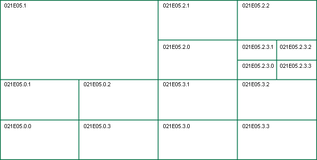
The CanVec product is tiled based on National Topographic System (NTS) map sheets - see Canada_NTS_Tile_System. Each map sheet is subtiled using a quadtree algorithm. Subtree naming convention is SW=0, NW=1, NE=2, SE=3. A tile is splited when there is more than 25K nodes in it. Each tile is a separate .osm file. All files are zipped together.

How To
You can create a background for JOSM showing the NTS tiles as GPX tracks
http://picasaweb.google.ca/samvekemans/OpenStreetMap#5477503772618622914
Step 1: goto the site http://www.geobase.ca/geobase/en/browse.do?produit=cded&decoupage=250k&map=canada to figure out what NTS tile your interested in.
Step 2: goto ftp://ftp2.cits.rncan.gc.ca/pub/index/kml_files/
download the larger area your working on
Set 3: use convert it to GPX
- Use http://www.gpsvisualizer.com/ and convert the .kmz file to GPX
Step 4: Save this converted file as a *.gpx file
Step 5: In JOSM open up this file.
Step 6: You can now work in this NTS tile area. JOSM might let you download it all in 1 go, it might be small enough
Sample
Here is an example of the NTS tile 011 area as GPX tracks.
You can download the GPX track file here http://www.mediafire.com/file/goywzdzy3my/NTS_011_Grid_POI.gpx
