DE:Featured images/Jan-Mar 2011
Jump to navigation
Jump to search


Hier sind die vorgestellten Bilder zu sehen. Die Bilder wurden als Vorzeigebeispiele des OpenStreetMap-Projektes auserwählt.
Wenn du ein Bild hast, welches als Bild der Woche sein könnte, dann kannst du es hier auf der (en) Vorschläge des ausgewählten Bildes-Seite vorschlagen.
| ← von Januar bis März 2010 | ← von Oktober bis Dezember 2010 | von April bis Juni 2011 → | von Januar bis März 2012 → |
Galerie der vorgestellten Bilder, von Januar bis März 2011

2011, Woche 1

2011, Woche 2

2011, Woche 3
2011, Woche 4
2011, Woche 5
2011, Woche 6

2011, Woche 7

2011, Woche 8
2011, Woche 9

2011, Woche 10
2011, Woche 11
2011, Woche 12
2011, Woche 13
Details und Beschriftungen
Woche 1 (von Montag, 3. Januar 2011 bis Sonntag, 9. Januar 2011) [Edit]

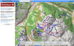
- English : Snowsports maps from openpistemap.org with contours and hillshading. Hitting the slopes this winter? Check out WikiProject Piste Maps.
- Deutsch : Wintersportkarten auf openpistemap.org mit Geländekonturen und Schatten. Auf Pisten oder Loipen unterwegs? Mehr zur Mithilfe auf WikiProject Piste Maps.
Woche 2 (von Montag, 10. Januar 2011 bis Sonntag, 16. Januar 2011) [Edit]

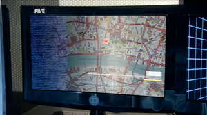
- English : OpenStreetMap on British TV (episode The Bounty Hunter in series K-9).
- Deutsch : OpenStreetMap im englischen Fernsehen in der Folge “The Bounty Hunter” der Serie “K-9”, ein “Doctor-Who”-Ableger.
Woche 3 (von Montag, 17. Januar 2011 bis Sonntag, 23. Januar 2011) [Edit]

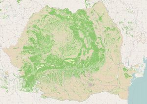
- English : Romanian landuse – data from EEA comprises 100K polygons, imported to OSM December 2010
- Deutsch : Rumänische Landschaftsnutzung – Daten der EEA bestehend aus 100 000 Polygonen wurden im Dezember 2010 in OSM importiert.
Woche 4 (von Montag, 24. Januar 2011 bis Sonntag, 30. Januar 2011) [Edit]

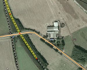
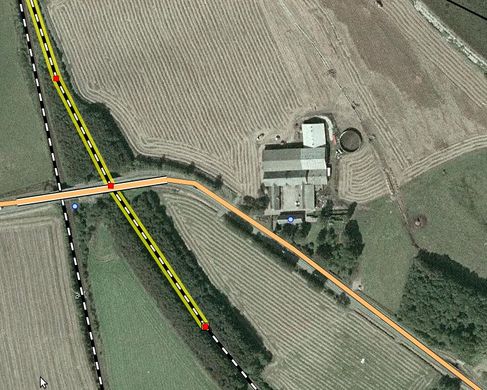
- English : Fugro has shared their 40 cm Danish photography with OpenStreetMap [Thanks to Peter Brodersen and Jonas Häggqvist for making this happen]. See the project page for instructions on tracing it with JOSM/Potlatch2.
- Deutsch : Fugro gibt seine dänischen 40-cm-Luftbilder für die Arbeit in OpenStreetMap frei (Danke an Peter Brodersen und Jonas Häggqvist für die Vermittlung). Auf den Projektseiten finden sich Hinweise zur Nutzung in JOSM/Potlatch2.
Woche 5 (von Montag, 31. Januar 2011 bis Sonntag, 6. Februar 2011) [Edit]

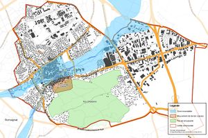
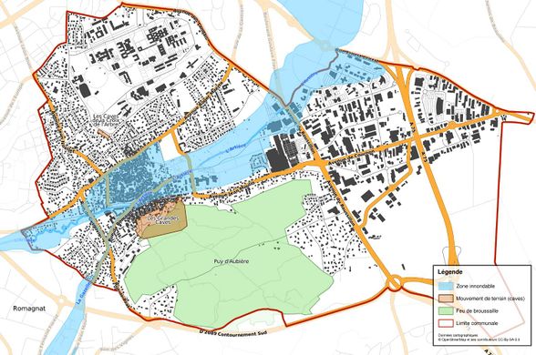
- English : Municipality council using Nicolas Dumoulin's map of potential flood, fire, cave-in hazards in a town.
- Deutsch : Die Risikoanalyse für Überflutungen, Feuer und mögliche Erdbewegungen in einem Ort in Frankreich wurde von Nicolas Dumoulin mit OpenStreetMap-Daten im Auftrag des Gemeinderats erstellt.
Woche 6 (von Montag, 7. Februar 2011 bis Sonntag, 13. Februar 2011) [Edit]

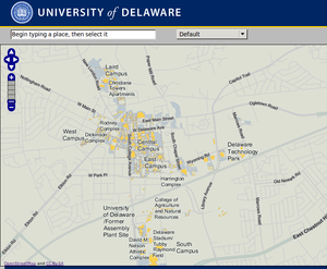
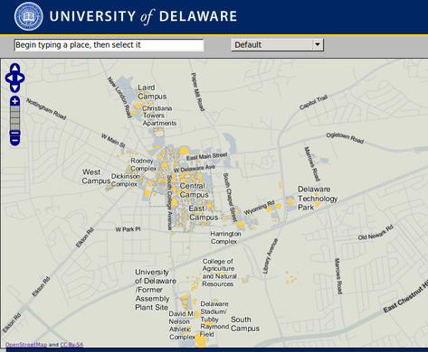
- English : Campus map uploaded to OSM by University of Delaware (and see the selectable vector buildings on their website!)
- Deutsch : Campusplan, Hochgeladen zu OSM durch die Universität von Delaware (siehe auch die auswählbaren Vektorgebäude auf deren Webseite!)
Woche 7 (von Montag, 14. Februar 2011 bis Sonntag, 20. Februar 2011) [Edit]

- English : glosm is a hardware-accelerated OpenGL-based OpenStreetMap renderer, producing 3D renderings like this one of an area of Moscow
- Deutsch : glosm ist ein Hardware-unterstützter OpenGL-basierter OpenStreetMap-Renderer, der 3D-Ansichten erzeugen kann, hier am Beispiel eines Gebiets in Moskau.
Woche 8 (von Montag, 21. Februar 2011 bis Sonntag, 27. Februar 2011) [Edit]

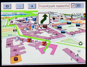
- English : Gosmore showing route in a 3D map of Freizeitpark Marienfelde, Berlin
- Deutsch : Die Software Gosmore mit einer 3D-Karte des Freizeitparks Marienfelde, Berlin
Woche 9 (von Montag, 28. Februar 2011 bis Sonntag, 6. März 2011) [Edit]

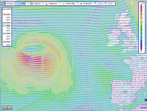
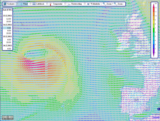
- English : OpenSeaMap showing a storm in the North Atlantic. Data provided by US and rendered by bluewater-info.net.
- Deutsch : Wettervorhersage in OpenSeaMap:
Sturm im Nordatlantik. Rendering von bluewater-info.net. Windrichtung und -Stärke, Luftdruck, Lufttemperatur, Niederschlag, Wellenhöhe
Woche 10 (von Montag, 7. März 2011 bis Sonntag, 13. März 2011) [Edit]

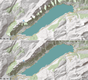
- English : Maperitive's custom DEM support showing detail of Viewfinder's Alps SRTM1 DEM compared to SRTM, for Lake Brienz area. (also visible on [1] [2] [3] topo maps)
- Deutsch : Vergleich der Ausgaben von Maperitive mit individuellem DEM "Alps SRTM1 DEM" von Viewfinder im Vergleich mit SRTM, für die Gegend um den Brienzersee. (auch zu sehen auf den Topo Karten von [4] [5] [6])
Woche 11 (von Montag, 14. März 2011 bis Sonntag, 20. März 2011) [Edit]

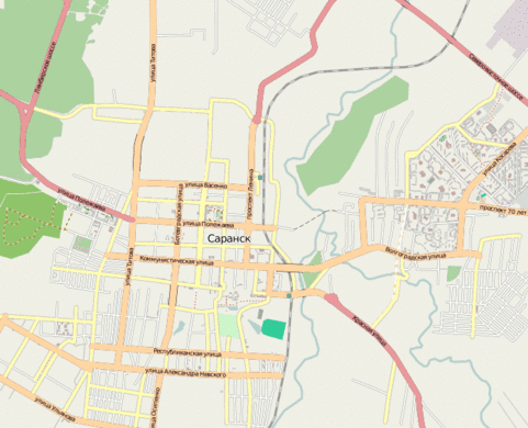
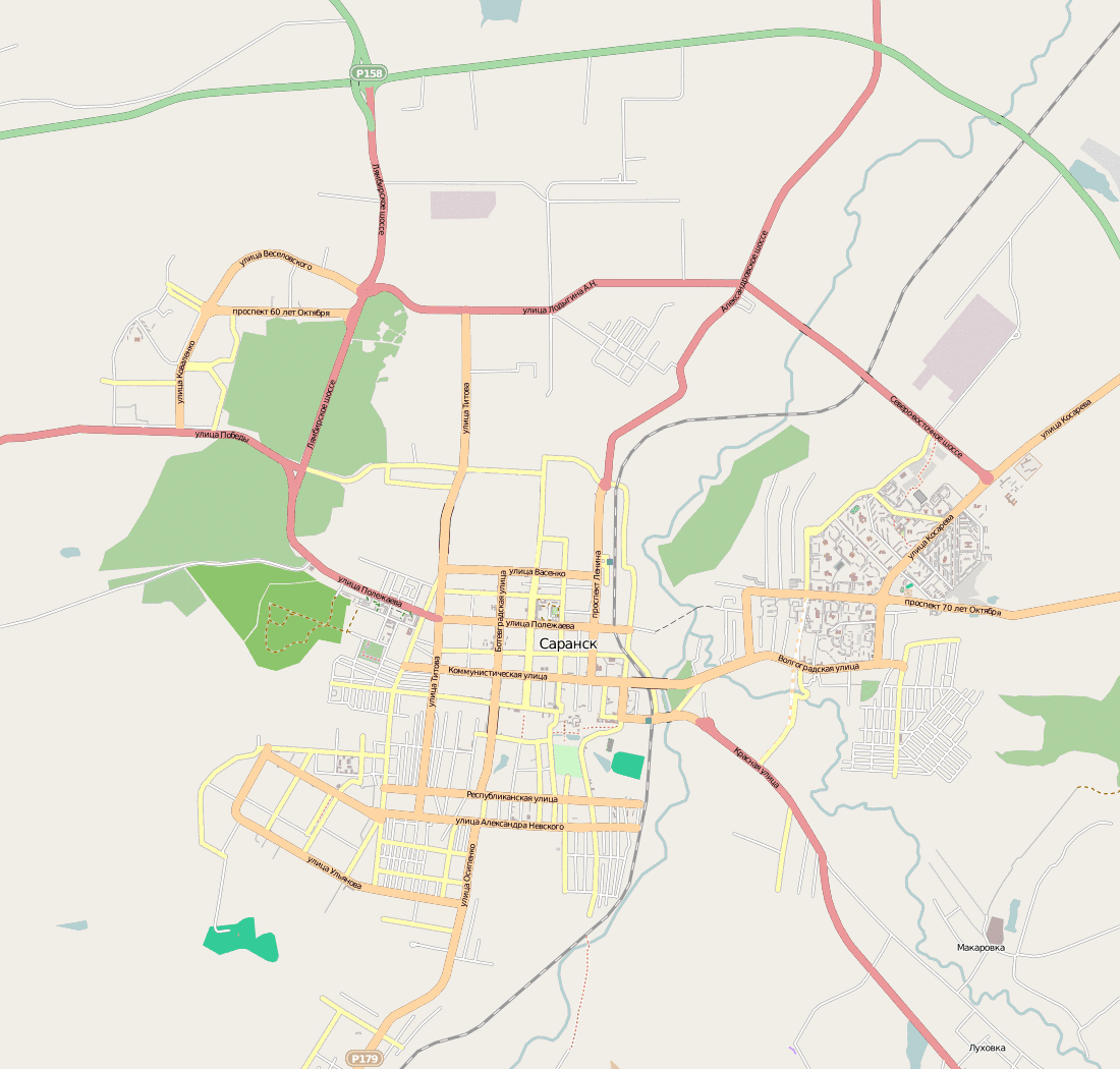
- English : City of Saransk was mapped in only 50 hours. User osmisto has organized the first Russian online mapping party: it's still cold outside, so almost everyone attended. The pie, animation (4 MB), forum.
Woche 12 (von Montag, 21. März 2011 bis Sonntag, 27. März 2011) [Edit]

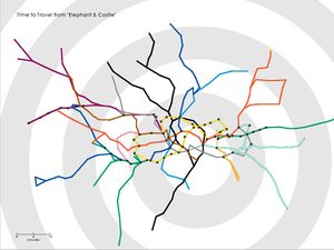
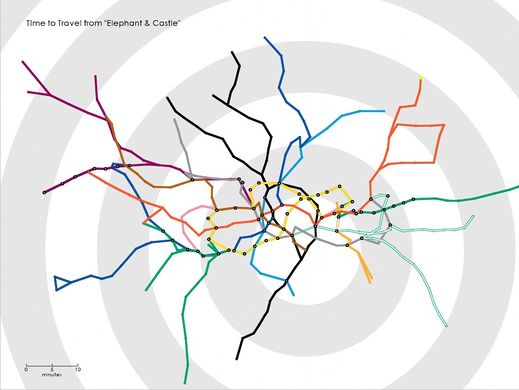
- English : Tom Carden's Travel Time Tube Map creates isochronic maps of the London Underground
Woche 13 (von Montag, 28. März 2011 bis Sonntag, 3. April 2011) [Edit]

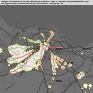
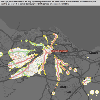
- English : Example of mySociety's travel maps, showing start-locations from which one type of transport beats another (in this case, public-transport vs car)
- Deutsch : Beispiel von mySociety's travel maps, das Startpunkte anzeigt wo ein Verkehrsmittel schneller ist als ein anderes. Hier ist der öffentliche Nahverkehr mit Autos verglichen.