ES:Openrouteservice
Si comprendes el artículo original en inglés, por favor, ayuda a completar esta traducción al español. Lee las instrucciones sobre cómo traducir este wiki.
Parece que nadie está trabajando en la traducción en este momento. Anímate y colabora en la tarea de traducción.
HeiGIT • ES:Openrouteservice • Ohsome
Ohsome API • OSHDB • Ohsome Dashboard • OhsomeHeX • Ohsome quality analyst
Openrouteservice (Website - short ORS) is much more than a website with a route service for cars, pedestrians and bicycles based on Open Standards and Open Geodata. Several Location Based Services (LBS) created from OSM data are available, developed by HeiGIT - Heidelberg Institute for Geoinformation Technology. For example :
- Directions Service
- Matrix Service
- Geocoding Service
- Locations Service
- Isochrones Service
| Open Route Service | |
|---|---|
| Autor: | GIScience |
| Licencia: | Creative Commons Attribution-ShareAlike 2.0 |
| Plataformas: | API y Web |
| Versión: | 24.1 |
| Lenguajes: | checo, alemán, inglés, español, francés, italiano, neerlandés, polaco, húngaro, ruso y ucraniano |
| Sitio web: | https://openrouteservice.org/ |
|
Easy to use, nice UI | |
Información General
| Online desde: | April 2008 |
|---|---|
| Desarrollado por: | Pascal Neis, further developed by Maxim Rylov, Enrico Steiger and others |
| Idea: | Pascal Neis & Alexander Zipf University of Heidelberg GIScience (Geoinformatics) Research Group ([1]) |
| Soporte actual para los paises: | Complete Europe, Asia, Africa, Australia, Oceania (routing and geocoder)
Worldwide: Directory Service (POI-search)] |
| Lenguajes soportados para RouteInstructions (Route Service): | see Openrouteservice/Instructions |
| Algoritmos de ruteo OLS Route Service: | Combination of Contraction Hierarchies and A* (A-Star) |
| GitHub | [2] developed by: Timothy <ellersiek, Carina Lannig, Oliver Roick and others |
| Fecha de actualización: (NUEVO mecanismo de actualizacón desarrollado e implementado (06/2014) | Enrico Steiger, Maxim Rylov, Lukas Loos, https://www.geog.uni-heidelberg.de/gis/mitarbeitende_en.html |
Requisitos de reporte, Feedback general, comentaris, sugerencias, bugs, preguntas vía email a openrouteserviceATgeog.uni-heidelberg.de
Que puede hacer con ORS?
Openrouteservice.org es más que solo un servicio de ruteo: utiliza una amplia gama de servicios basados en datos de OSM que también podrían utilizarse en otras aplicaciones y escenarios. Actualmente los siguientes servicios se han implementado en el marco de Openrouteservice.org basado en los datos de OSM son:
- El Directorio de Servicios es un servicio que proporciona acceso a un directorio en línea para encontrar la ubicación de un lugar, producto o servicio específico o más cercano.
- El Servicio de localización útil provee Geocode inversa/Geocoder; la Geocoder transforma una descripción de un lugar, como un nombre de lugar, dirección o código postal, en una descripción normalizada de la ubicación con una geometría Point.
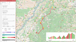
- El Servicio de Rutas determina las rutas de viaje e información de navegación de acuerdo a diversos criterios. Esto se ha realizado para:
- coches: más rápido, más corto, recomendados.
- several options to avoid tools, tunnels, etc.
- same for heavy vehicles with many options
- wheelchair routing (beta)
- cars: use of realtime traffic (TMC), for GERMANY
- bicycles (MTB, race bike, safest route...)
- pedestrian
- further extensions (particular options for different types of bicycles etc.) are planned or in work
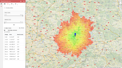
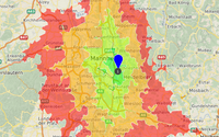
- The Accessibility Analysis Service (AAS) calculates a polygon representing the area that is reachable within a certain time distance based on a street network around a given location.
- In the Emergency Route Service you can specify areas that will be avoided by your route.
- ...
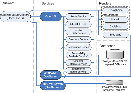
Components of ORS
Components of ORS from Neis (2008)
Used OSM Tags for Routing
| Car Routing | Pedestrian Routing | Bicycle Routing | |||
|---|---|---|---|---|---|
| Key | Value (km/h -> speed used in ORS) | Key | Value (km/h -> speed used in ORS) | Key | Value (km/h -> speed used in ORS) |
| highway | motorway (110 km/h) & motorway_link (90 km/h), trunk (90 km/h) & trunk_link (70 km/h), primary (70 km/h) & primary_link (60 km/h), secondary (60 km/h) & secondary_link (50 km/h), tertiary (55 km/h) & tertiary_link (45 km /h), unclassified (50 km/h), residential (40km/h), living_street (10 km/h), service (30 km/h)* | highway | (trunk & trunk_link till october) primary & primary_link, secondary & secondary_link, tertiary & tertiary_link, unclassified, residential, living_street, service, track, pedestrian, cycleway*, footway, bridleway*, steps, path (on all ways 6 km/h) | highway | (trunk & trunk_link till october) primary & primary_link, secondary & secondary_link, tertiary & tertiary_link, unclassified, residential, living_street, service, track, cycleway, footway*, bridleway*, pedestrian*, path (on all ways 16 km/h) |
| access | yes, no | ||||
| motorcar | yes, no | foot | yes, no | bicycle | yes, no |
| oneway | yes, true, 1, no, false, -1 | oneway | yes, true, 1, no, false, -1 | ||
| junction | roundabout | cycleway | opposite, opposite_lane, opposite_track, track | ||
| route | ferry | route | ferry | route | ferry |
| maxspeed (in work) | only if the value is a number, e.g. '30'. '30 km/h' or similar are not supported! Further, only speeds between 5 and 130 km/h are used. mph will be transformed. | ||||
| * if allowed | |||||
additional project on adding wheelchair routing: http://wiki.openstreetmap.org/wiki/DE:Rollstuhlfahrer-Routing
it is also used for haiti emergency routing: http://openls.geog.uni-heidelberg.de/osm-haiti/
RouteInstructions
Please help to improve the Instructions and the many translations! (ca. 40 languages and dialects supported so far!)
Route Service Comparison Matrix
A comparison matrix is available at Routing/OnlineRouters#Route service comparison matrix
Evaluation of data fitness for routing
ORS hits, route requests and failures due to errors in street network over the course of time (Schmitz, Zipf & Neis (2008))
Openrouteservice API
Direct Routing Request (via GET)
Parameters
additional Parameter only for HeavyVehicle route profile
|
References
Papers related to Openrouteservice, OpenLS+OSM in some of our applications and projects: cmp.: https://www.geog.uni-heidelberg.de/gis/publikationen_journals.html https://www.geog.uni-heidelberg.de/gis/publikationen_conference.html
- Steiger, E. and Zipf, A.(2015): Enriching OSM road networks with TMC LCL information. RICH-VGI: enRICHment of volunteered geographic information (VGI): Techniques, practices and current state of knowledge. 18th AGILE Conference on Geographic Information Science. Lisbon, Portugal.
- Barron, C., Neis, P. & Zipf, A. (2013): A Comprehensive Framework for Intrinsic OpenStreetMap Quality Analysis. , Transactions in GIS, DOI: 10.1111/tgis.12073.
- Ballatore, A. and Zipf, A. (2015): A Conceptual Quality Framework for Volunteered Geographic Information. COSIT - CONFERENCE ON SPATIAL INFORMATION THEORY XII. October 12-16, 2015. Santa Fe, New Mexico, USA. Lecture Notes in Computer Science, pp. 1-20.
- Neis, A. & Zielstra, D. (2014): Generation of a tailored routing network for disabled people based on collaboratively collected geodata. Applied Geography. Vol. 47, pp. 70–77.
- Neis, P. (2014): Measuring the Reliability of Wheelchair User Route Planning based on Volunteered Geographic Information. Transactions in GIS.
- Goetz, M. & Zipf, A. (2012): Using Crowdsourced Indoor Geodata for Agent-Based Indoor Evacuation Simulations. ISPRS International Journal of Geo-Information. Vol.1(2), pp.186-208. MDPI. DOI:10.3390/ijgi1020186.
- Neis, P. & Zipf, A. (2012): Analyzing the Contributor Activity of a Volunteered Geographic Information Project – The Case of OpenStreetMap. ISPRS International Journal of Geo-Information. Vol.1(2), pp.146-165. MDPI. DOI:10.3390/ijgi1020146 .
- Steiger, E. Zipf, A.(2015): Erstellungs eines OSM Graphen mit TMC LCL Informationen In: Strobl, J., Blaschke, T., Griesebner, G. (Hrsg.): Angewandte Geoinformatik 2015. Berlin
- Neis, P., Zielstra, D. & Zipf, A. (2012): The Street Network Evolution of Crowdsourced Maps - OpenStreetMap in Germany 2007-2011. Future Internet. Special Issue "NeoGeography and WikiPlanning" (Eds: B. Murgante, G. Borruso, M. Gibin), Vol.4, pp.1-21 (DOI 10.3390/fi4010001). ISSN 1999-5903.
- Sun, Y., Fan, H., Bakillah, M. & Zipf, A. (2013): Road-based Travel Recommendation Using Geo-tagged Images. Computers, Environment and Urban Systems (CEUS). Elsevier.
- Neis, P., Zielstra, D. & Zipf, A. (2013): Comparison of Volunteered Geographic Information Data Contributions and Community Development for Selected World Regions. Future Internet. Vol. 5, pp. 282-300.
- Goetz, M. & Zipf, A. (2011): Formal Definition of an User-adaptive and Length-optimal Routing Graph for Complex Indoor Environments. Geo-spatial Information Science (GSIS). Vol.14(2). Springer.
- John, S., Hahmann, S., Zipf, A. (2015): Automatisierte Ableitung des Gefälles von Straßen und Wegen aus OpenStreetMap GPS-Tracks. 59. Deutscher Kongress für Geographie (DKG 2015). Berlin, Germany. (accepted as presentation).
- Neis, P. and Zipf, A. (2008): Generating 3D Focus Maps for the (mobile) Web - an interoperable approach. In: International Journal of Location Based Services (JLBS). Vol. 2, Issue 2.
- Neis, P. and Zipf, A. (2007): Realizing Focus Maps with Landmarks using OpenLS Services. 4th International Symposium on LBS and Telecartography 2007. Hongkong.
- Neis, P., A. Zipf, R. Helsper, Kehl, A. (2007): Webbasierte Erreichbarkeitsanalyse - Vorschläge zur Definition eines Accessibility Analsysis Service (AAS) auf Basis des OpenLS Route Service. REAL CORP 2007. Wien, Austria.
- Schmitz S., Zipf A. and Neis P. (2008): New Applications based on Collaborative Geodata - the Case of Routing. XXVIII INCA International Congress on Collaborative Mapping and SpaceTechnology, Gandhinagar, Gujarat, India
- Zipf, A., Neis, P. und Fellner M. (2008): Wirbelstürmer - Freie Mapping- und Routing-Services mit von Usern erzeugten Karten. In: LINUX Magazin (Professoren-.Ausgabe). 01/09 (erschienen 12/2008). S 34-39. https://www.linux-magazin.de/ausgaben/2009/01/wirbelstuermer/
- Neis P. and A. Zipf (2008): LBS_2.0 - Realisierung von Location Based Services mit user-generated, collaborative erhobenen freien Geodata. In: J. Roth (Hrsg.): 5. GI/ITG KuVS Fachgespräch Ortsbezogene Anwendungen und Dienste, 4.-5. September 2008, Nürnberg. Sonderdruck Schriftenreihe der Georg-Simon-Ohm-Hochschule Nürnberg Nr. 42, ISSN 1867-5433
- Schmitz, S., Zipf, A. and Pascal Neis (2008): Proposal to define common resources for OpenGIS Location Services. 5th International Symposium on LBS & TeleCartography. Salzburg. Austria.
- Haase M., A. Zipf , P. Neis , V. de Camargo (2008): Interoperable Routing Services in the Context of Evacuation Schemes due to Urban Flooding. EnviroInfo 2008 Conference. Environmental Informatics and Industrial Ecology. Lueneburg, Germany.
- Neis, P., Zipf, A (2008): OpenRouteService.org is three times “Open”: Combining OpenSource, OpenLS and OpenStreetMaps. Accepted for: GIS Research UK (GISRUK 08). Manchester.
- Brinkhoff,T., M. BERTLING, J. BIERMANN, T. GERVENS, R. KÖNIG, D. KÜMPER, P. NEIS, B. STOLLBERG, C. ROLFS, A. WEISER, J. WEITKÄMPER, A. ZIPF (2008): Offenes Katastrophenmanagement mit freiem GIS Zur interoperablen Kopplung von Leitstellensystem, mobilen Clienten und GDI mit Prozessierungsdiensten. AGIT 2008. Symposium für angewandte Geoinformatik. Salzburg. Austria.
- Weiser, A., P. Neis, A. Zipf (2006): Orchestrierung von OGC Web Diensten im Katastrophenmanagement - am Beispiel eines Emergency Route Service auf Basis der OpenLS Spezifikation. In: GIS - Zeitschrift für Geoinformatik. 09/2006. pp. 35-41.
- Neis, P. und Zipf, A. (2008): OpenStreetMap – Grundlagen und Potentiale der freien Wiki-Weltkarte. GIS Report 2008/2009. Harzer Verlag. Karlsruhe.
- Neis, P. und Zipf, A. (2008): LBS 2.0 mit OpenRouteService.org - die OpenGIS-konforme Routing-Plattform auf Basis der freien Geodaten von OpenStreetMap. GIS Report 2008/2009. Harzer Verlag. Karlsruhe.
- Neis, P., A. Schilling, A. Zipf (2007): 3D Emergency Route Service (3D-ERS) based on OpenLS Specifications. GI4DM 2007. 3rd International Symposium on Geoinformation for Disaster Management. Toronto, Canada.
- Neis, P., A. Zipf (2007): A Web Accessibility Analysis Service based on the OpenLS Route Service. AGILE 2007. International Conference on Geographic Information Science of the Association of Geograpic Information Laboratories for Europe (AGILE). Aalborg, Denmark.
- Bauer, M., P. Neis, C. Weber, A. Zipf (2007): Kontextabhängige Landmarken für mobile 3D Navigationsanwendungen. In: 4. Fachgespräch: Ortsbezogene Anwendungen und Dienste. LMU München.

