FR:Mapping milestones
| Une grande partie de cette page n'a plus qu'une valeur historique (depuis mai 2016). |
- Trouvez ici des étapes importantes de cartographie dans le développement d'OpenStreetMap. Pour plus d'informations sur la façon de cartographier des établissements et lieux inoccupés, voir FR:Places.
La meilleure façon de découvrir des endroits que nous avons cartographiés est de regarder la carte, notre interface de navigation permettant de faire un panoramique et de zoomer sur des détails intéressants.
La carte n'est pas terminée. Ce sont encore les débuts du projet, alors ne soyez pas déçu si votre commune n'est pas encore entièrement cartographiée. Nous créons des cartes qui peuvent être produites avec notre open license, ce qui signifie que nous ne pouvons pas copier facilement d'autres sources, et dans de nombreux endroits, nous sommes obligés de sortir et arpenter les rues à partir de zéro. C'est pourquoi notre couverture est limitée pour le moment. Il s'agit d'un processus graduel, mais que nous espérons accélérer avec l'implication de plus en plus de personnes dans notre processus de création de carte.

Sur cette page, nous allons attirer l'attention sur quelques exemples intéressants de lieux que nous avons cartographiés, et les étapes de cartographie que nous avons atteint, mais ce ne sont certainement pas les seuls endroits où la cartographie est en cours. Pour découvrir ce qui se passe près de chez vous, jetez un œil à la carte et aussi les pages sous Mapping projects où nous décrivons et coordonnons nos activités de cartographie basées pays par pays.
Royaume-Uni
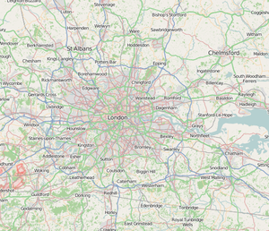
Londres est la ville natale du projet OpenStreetMap. Les premiers éléments ont été fixés dans Regents Park durant l'été 2004 (voir History of OpenStreetMap). Merci à toutes les participations à la London mapping party Jan 2007 et à l'effort continu de cartographie d'une grande communauté basée dans et autour de Londres pour les excellents progrès qui ont été réalisés. Londres est probablement notre meilleur exemple d'un effort de collaboration, rassemblant les contributions de beaucoup de personnes. Tout n'y est pas encore totalement cartographié mais Londres est l'une des plus grandes villes du monde, aussi nous faisons de notre mieux et il y a toujours plus de détails.

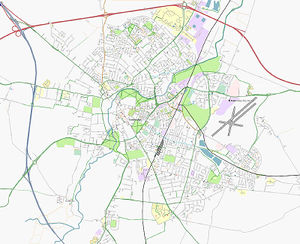
Ailleurs dans le Royaume-Uni, d'autres villes ont fait encore plus de progrès. Cambridge a été la première ville à être décrit comme «complète», mais dans le vrai style wiki, une carte n'est jamais vraiment terminée. Nous pouvons toujours continuer à apporter des améliorations et ajouter des fonctionnalités de cartographie toujours plus détaillées. Mais bien sûr, ce n'est pas seulement les villes qui nous intéressent, nous cherchons à tracer les interconnexions routes/rails, et finalement chaque petite route de campagne. Un bon exemple de cela, c'est l'île de Wight. Ce fut l'emplacement d'un effort concerté de cartographie durant un long week-end, puis de suivi des travaux par un contributeur qui vit là-bas. Il pense que toutes les routes sur cette île de 380 km² ont été cartographiées.
Pays-Bas
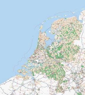
You will also notice a remarkably finished off map of roads covering the entire Netherlands. A mapping agency called AND decided to donate their data to the project, allowing us to import it and release it with our open license. Their data, and the script development effort by our dutch community, has yielded a fantastic map of the whole country.
Allemagne
Elsewhere in Europe new sprouts of mapping effort are taking off all the time. Germany deserves special mention, with a very active community of mappers, and lots of OSM developers coming from this country. Likewise Sweden, Norway and Denmark were in on the action early on, but we're seeing a lot of mapping activity in all of the European countries these days (Find your country linked off Mapping Projects)
Etats-Unis d'Amérique
You might expect an Internet collaboration like this to take off in the United States. Well, the situation around free mapping data is rather different in the USA, and rather better, in that all government data are released into the public domain. This includes TIGER data, a vector representation of every street in the USA. We found that these data were rather crude and required a lot of clean-up before we were able to import them into our database. These technical challenges, as well as problems around scaling the database to hold these data, have meant that we only recently made progress with importing TIGER data.

The cleansed data that OpenStreetMap now offers do have advantages over the raw TIGER data. Now that these data are largely in place, and the project is able to render maps in the States, it is hoped that OpenStreetMap will attract more American contributors. There is a lot of manual TIGER fixup work to be done, plus gathering of data related to other detailed Map Features, which OpenStreetMap is capable of supporting through wiki-style community contribution.
In July 2013 an important milestone was declared in the USA: OpenStreetMap's Cycle Map layer is asserted to display a "substantially accurate representation" of the numbered United States Bicycle Route (USBR) system, including both actual and truly proposed routes. (This rendering displays only actual, not proposed routes). While statewide (regional) and local bicycle routing networks continue to emerge and are improved in OSM, the nascent USBR national numbering is now up-to-date. OSM will continue to track proposed and new numbered national bicycle routes across the USA as they develop and are approved by the People for acceptance by AASHTO, the US highway numbering standards association.
Canada
In Canada there is also data available from the government. There are several Canadian government datasets that OpenStreetMap has been granted permission to convert and import as of November 2008. The conversion and import process has commenced in 2009.
Baghdad
In February 2007 we made a concerted effort to map out the streets of Baghdad. This was an experiment in mapping by remote, making use of Yahoo! Aerial Imagery. As explained in this blog post, OpenStreetMap now has the most comprehensive map of Baghdad among any of the web mapping services, but we are calling out for more contributions from people in these locations to help refine the rough road-layout information we have started with.
Haïti
In January 2010, an earthquake struck the Island of Haiti, leading to a very efficient mapping effort by mappers all around the world to quickly convert satellite images into maps that could be used in the field by rescue teams. See WikiProject_Haiti
Equally in other developing world locations, there is great potential for our maps to make a difference. In some regions the availability of a good map could help massively with management of supplying basic food/water/health supplies, or development of infrastructure. We need to work to make use of Yahoo! Aerial Imagery and other data-sources in whatever way we can, but contributions from local people on the ground will be very welcome.
Find out more about mapping the place where you live, under Mapping Projects.

