Fa:Android
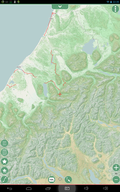
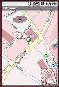
اندروید سیستمعاملی مبتنی بر لینوکس برای گوشیهای تلفن همراه و سایر دستگاههای همراه است. با استفاده از دستگاههای اندروید میتوانیم نقشههای مبتنی بر OpenStreetMap را مشاهده و ویرایش کنیم و همچنین مسیرهای GPS ضبط کنیم که بعداً میتوان در OSM بارگذاری کرد تا به ویرایش نقشه کمک کنیم.
جهت اطلاعات بیشتر در مورد اندروید و OpenStreetMap، ردهٔ اندروید را ببینید.
OpenStreetMap.org
ابتداییترین روش استفاده از اوپناستریتمپ در دستگاه اندروید، باز کردن http://www.openstreetmap.org/ در مرورگر وب (مانند کروم) است. این وبسایت برای صفحههای کوچک نیز بهینه شده است و از ژستهای حرکتی مانند کشیدن برای جابهجایی و زوم دوانگشتی پشتیبانی میکند. برای تجربهٔ مشاهدهٔ نقشه مشابه گوگلمپس بخش برنامهها را ببینید. بهطور مشابه، برای مشارکت در اوپناستریتمپ ویرایشگر iD که در وبسایت تعبیه شده، در حد ابتداییتری در تبلتها قابلاستفاده است. اما احتمالاً با یک برنامهٔ ویرایشگر اندروید راحتتر خواهید بود.
برنامههای OpenStreetMap
- مقالهٔ اصلی: Comparison of Android applications
The following applications rely on OpenStreetMap for core functionality, so they’re good ways to use OpenStreetMap on your Android device. Each of these applications is actively maintained, with a new release within the last 18 months, as of 11:02, 26 June 2016 (UTC). For a comprehensive comparison of all available Android applications, see Comparison of Android applications.
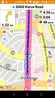
ناوبری
این برنامهها ناوبری لحظهای و در بسیاری موارد همراه با راهنمای صوتی ارائه میدهند:
منبعباز
انحصاری
- Galileo Offline Maps main.png
Guru Maps
(Galileo Offline Maps) - Locus with recorded track.png


Nearby Explorer و Nearby Explorer Online
همچنین امکان بارگزاری نقشههای مبتنی بر OpenStreetMap در برنامههای ذیل وجود دارد:
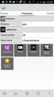
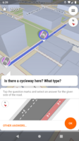
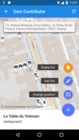
ویرایش نقشه
این ویرایشگرهای پیشرفته از طریق ویرایش مستقیم نقشه، اجازه مشارکت کردن در OpenStreetMap را میدهند:
ویرایش غیرمستقیم داده:
ویرایش محدود:
- Locus Map Pro screenshot with geocaches.png


این برنامهها اجازه استفاده از تصاویر خیابانی برای کسانی که از راه دور نقشهکشی میکنند را میدهند:
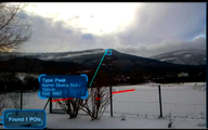
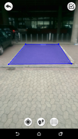
واقعیت افزوده
این برنامهها دادههای OpenStreetMap را روی نمای واقعی که توسط دوربین پشتی دستگاه گرفته میشوند قرار میدهند:

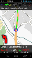
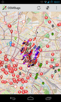
ضبط مسیر
این برنامهها به شما اجازه میدهند که مسیر حرکت خود را ضبط کنید. میتوانید مسیر GPS خود را به OpenStreetMap آپلود کنید تا به دیگران کمک کنید که عوارضی به نقشه اضافه کنند. بسیاری از این برنامهها نیز قابلیتهای ناوبری دارند که در بخش برنامههای ناوبری آمدهاند.
- Galileo Offline Maps main.png
- Locus with recorded track.png


Maps.me - Record GPS track in DAT format. The track will be removed automatically from the map after the time interval will expire (1 hour by default).
GPS accuracy
If you are recording GPS tracks with an Android phone, it can be useful to have an application to help you troubleshoot your GPS data. A GPS testing application can help you determine which GNSS satellite networks your phone supports (Beidou, Galileo, GLONASS, GPS, QZSS, etc.). It can also help you determine the satellites it can see and is using at any given time, which frequencies your device listens on (whether it supports dual band signals, for example), and the accuracy of the data your phone reports.
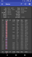
GPSTest (Google Play) (Project page)

برنامهریزی سفر
این برنامهها به شما اجازه جستجو و یادگیری مکانهای روی نقشه را میدهند. اغلب آنها از نقشه آفلاین هم پشتیبانی میکنند.
- Locus with recorded track.png


.png)


بازی
- مقالهٔ اصلی: Games#In the game itselfThese games rely on OpenStreetMap data to power gameplay:
- Pokémon Go App.jpg
متفرقه


Applications using OpenStreetMap
این برنامهها هم به نحوی از OpenStreetMap استفاده میکنند:
کتابخانهها برای توسعهدهندگان
- مقالهٔ اصلی: Frameworks
Several libraries make it easy for Android developers to incorporate OpenStreetMap in their own applications, whether as a static map image, a fully interactive map, or more sophisticated uses like geocoding and routing. Another benefit of using these libraries is that they respect OpenStreetMap’s tile usage policy by fetching tiles and other resources from dedicated servers instead of OpenStreetMap’s donated servers.
There are also a number of projects on GitHub and Google Code with both 'android' and 'openstreetmap' tags.
نقشه
| Library | Minimum API level | License | Notes | ||||||||||||||||||||||||||||||||||||||||||||||
|---|---|---|---|---|---|---|---|---|---|---|---|---|---|---|---|---|---|---|---|---|---|---|---|---|---|---|---|---|---|---|---|---|---|---|---|---|---|---|---|---|---|---|---|---|---|---|---|---|---|
| Carto Mobile SDK | 11 | BSD | Supports 3D city overlays, editable vector overlays and is highly customizable. | ||||||||||||||||||||||||||||||||||||||||||||||
| CartoType | 14 | Proprietary | Offline rendering and routing library using OpenGL ES; customisable style sheets; 2.5D perspective view with 3D buildings | ||||||||||||||||||||||||||||||||||||||||||||||
| GLMap | 14 | Proprietary | Offline or online vector map rendered on device using OpenGL ES | ||||||||||||||||||||||||||||||||||||||||||||||
| LocationMapViewer | 10 | GPLv3+ | Android-Intent; "geo:"-Uri; gpx and kml file/url | ||||||||||||||||||||||||||||||||||||||||||||||
| Mapbox Android SDK | 15 | BSD | Customizable, interactive vector maps styled in Mapbox Studio and rendered using OpenGL ES. Hybrid components available for Cordova, NativeScript, React Native, and Xamarin. | ||||||||||||||||||||||||||||||||||||||||||||||
| Mapbox Android Services | 15 | MIT | Connects to Mapbox’s Static API | ||||||||||||||||||||||||||||||||||||||||||||||
| mapsforge | 9 | LGPLv3 | Map rendering, map overlays, and more | ||||||||||||||||||||||||||||||||||||||||||||||
| Navmii Mobile SDK | Unknown |
Proprietary | |||||||||||||||||||||||||||||||||||||||||||||||
| OSMBonusPack | 10 | LGPL with exceptions | Addon for osmdroid: Markers, Bubbles, Routes, Directions, KML and more... | ||||||||||||||||||||||||||||||||||||||||||||||
| osmdroid | 7 | Apache 2 | OSM based replacement for Android's MapView (v1 API) class. Supports online and offline tile sources and overlays for plotting icons, tracking location, drawing shapes. | ||||||||||||||||||||||||||||||||||||||||||||||
| OsmSharp | Unknown |
GPLv2 or commercial | Offline vector map rendering in C# using Xamarin | ||||||||||||||||||||||||||||||||||||||||||||||
| Skobbler Android SDK | 14 | Proprietary | |||||||||||||||||||||||||||||||||||||||||||||||
| Tangram ES | 15 | MIT | 2D and 3D map renderer using OpenGL ES, used to have its own vector tile service but as Mapzen went bankrupt it no longer exists. | ||||||||||||||||||||||||||||||||||||||||||||||
| VTM | 10 | GPLv3+ | 2D and 3D map renderer with own vector tile service; compatible with Mapsforge. | ||||||||||||||||||||||||||||||||||||||||||||||
| WhirlyGlobe-Maply | Unknown |
Apache 2 | }
Geocoding
|