Fa:OsmAnd
| OsmAnd | |
|---|---|
 | |
| سازنده: | Victor Shcherb and contributors |
| مجوز: | GPL v3 و artwork and design elements CC-BY-ND-NC (free or 6.99€) |
| سکوها: | Android، iOS، و BlackBerry OS |
| نسخه: | 4.7.1 (۲۰۲۴-۰۲-۰۶) |
| زبان ها: | انگلیسی، روسی، آلمانی، فرانسوی، عربی، بلغاری، بوسنیایی، چکی، دانمارکی، اسپانیایی، باسکی، فنلاندی، عبری، هندی، مجاری، ارمنی، اندونزیایی، ایتالیایی، jp، گرجی، کرهای، ایتالیایی، لتونیایی، مراتی، هلندی، نروژی، لهستانی، پرتغالی، رومانیایی، اسلواکی، صربی، سوئدی، اوکراینی، ویتنامی، چینی، و فارسی |
| سایت اینترنتی: | https://osmand.net |
| نصب: | |
| کد منبع: | https://github.com/osmandapp |
| زبانهای برنامه نویسی: | Java و C++ |
|
Navigation (routing) offline and online, OSM and custom map display (vector data or tiles, offline, cached or online), POI and address search (offline or online Nominatim), submit OSM bugs and POI, mark favorites, public transport info. Actively being developed. Keywords: GPS navigator, GPS navigation, navigation system, satellite navigation, sat nav, satnav, GPS tracker, GPS tracking, GPS map, OpenStreetMap, OSM viewer, map viewer, OSM mapping, offline routing, offline world map, global offline country maps, outdoor. | |
'OsmAnd' نرم افزار ناوبری Gps و برنامه نقشه است که در بسیاری از گوشی های آندروید و iOS و تبلت اجرا میشود و شامل نقشه های آفلاین اختیاری و چرخش نشانگر به هنگام چرخش است. OsmAnd، یک پروژه نرم افزاری مشترک و منبع باز (GPL) است که داده های openstreetmap را بصورت 100٪ رایگان با هدف ارائه یک راه حل کامل و کاربر پسند GPS برای تلفن همراه در اختیار قرار میدهد. نقشه برداری غنی، ناوبری، مسیریابی، نقاط مورد علاقه (POI)، و توابع ردیابی تاریخی همه به خوبی پشتیبانی می کند. این نرم افزار به خوبی بررسی شده، قابل اعتماد است در سطح جهانی توسعه یافته است و قابل اجرا بر روی بسیاری از گوشی های آندروید و iOS و تبلت و طیف وسیعی از سیستم های مبتنی بر لینوکس است.
نقشه های به روز و poi ها معمولا از قبل بارگذاری و روی دستگاه ذخیره میشود.در استفاده های بعدی نیازی به اتصال به اینترنت نیست،استفاده نامحدود بدون تحمیل هزینه های اینترنت و انتقال داده از مزایای این نرم افزار است. همچنین قابلیت اتصال GPS بدون وقفه و بدون محدودیت حتی در نبود پوشش سیگنال شبکه تلفن همراه را داراست.
داده OsmAnd و OSM کاملا فراتر قابلیت GPS معمولی است. اطلاعات Geodemographic از ویکیپدیا و دیگر منابع به عنوان POI نشان داده شده در نقشه های تلفن همراه گنجانده شده است. جزئیات نقشه (ذخیره شده به عنوان بردارهای و چند ضلعی) و داده POI اغلب بسیار غنی تر از دیگر نقشه های خارج از قفسه، معمولا بسته و سیستم های GPS استاتیک می باشد. مهمتر از همه، کل سیستم، داده های نقشه و نرم افزار مورد استفاده برای دستکاری و نمایش آن، جمع سپاری هستند. هر کاربر، به راحتی در دو دقیقه یا کمتر، بصورت رایگان ثبت نام کرده، و می تواند خطاهای openstreetmap را اصلاح، داده POI اضافه کند ،و یا یک اشکال نرم افزار OsmAnd را گزارش کند، و یا نشان می دهد و یا پیشنهاد برای بهتر شدن برنامه بدهد. به عنوان برنامه GPS تلفن همراه،نیاز به تکامل OsmAnd / openstreetmap را به سرعت پاسخ می دهد و در حال حاضر کامل باقی مانده است.
دانلود و نصب
Most users should use their preferred software supplier (e.g. App Store or Market) for convenience and automatic updates.
| Region | Service | Price |
|---|---|---|
| EU | Amazon (various) | € 3.99 |
| EU | Android Pit | € 5.99 |
| JP | Amazon | ¥ 399 |
| UK | Amazon | £ 2.99 |
| USA | Google Play | $5.99 |
| USA | Amazon Digital Services | $3.99 |
| Worldwide | iTunes App Store | Free |
Language support includes: Arabic, Chinese, Czech, Dutch, English, French, German, Greek, Hebrew, Hindi, Italian, Japanese, Korean, Polish, Portuguese, Russian, Spanish, Tagalog, Vietnamese (There may be more, this list expands rapidly.)
OsmAnd has limited availability, free of charge. If you opt for a free version please directly donate to support the project;
- OsmAnd: Latest market release, with two limitations: only 10 local downloads of maps, and no Wikipedia place data as POI;
- OsmAnd~: No limitations, maintained by F-Droid.
- Night Build: Latest development build for manual installation Select the OsmAnd-nightly.apk package, but be aware that it can be unstable or experimental, and manual installations are not auto-updated
For more OsmAnd versions and other projects, see OsmAnd's official downloads page.
OpenStreetMap map data and the OsmAnd application
OpenStreetMap (map data and server side components) and OsmAnd (Android / Java software for mobile use and navigation) are two large, open projects, therefore support concerns need to be initially divided between map "data" issues, and "software" issues. For instance, problems with the underlying map data (omissions, errors, inconsistencies, etc.) can cause OsmAnd to navigate inefficiently and miss the very best routes. Once the underlying data is completely cleansed or fully complete OsmAnd software will perform perfectly without modification.
The map data files are frequently updated and each update typically has hundreds if not thousands of corrections and additions. Likewise, Points of Interest (POI) data in particular requires constant vigilance to remain relevant and accurate with numerous organizations moving, or going in or out of business each month.
Supplying correcting map information to the OpenStreetMap organization is very easy. You can simply just report problems, and that by itself is very helpful. Or you can actually roll up your sleeves and edit the map data directly. After registering (a simple, two-minute process) you can use the free, very simple to use programs to edit the underlying data directly.
Please do your share of the hard work it is to keep the underlying OpenStreetMap data in pristine condition.
OpenStreetMap support and help (data and server)
- FAQ Frequently Asked Questions.
- Wiki for more comprehensive documentation.
- Forum great for discussion and peer support. see also Help Desk.
- Help Desk great for brief, pointed Q&A not covered elsewhere.
- Mailing Lists extensive ongoing discussions. Broken down by country and topical area.
پشتیبانی OsmAnd
OsmAnd is a large software project with millions of users worldwide. Relatively few people actually do the work to provide virtually everyone with a great application, built upon great data. If you have a support issue and resolve it through a convoluted, time consuming process, please go back and help update the FAQ, the Wiki, the Forum pages, etc. and make the path from support question to satisfactory answer as straight as possible. Make it much easier for the next person with the same issue to get to the solution. Help the coders document and best express the program's features, and explain all the typical use-cases. If you have Java programming experience by all means refactor, streamline and better document the running code, add well tested new features, and take it upon yourself to tackle any open item on the Issue List.
High quality, timely support requires many hands to make light the lifting. Please pitch in and contribute to OSMand's on-going support needs in any way you can.
Help for OsmAnd users
- The OsmAnd Home Page OsmAnd's official website. Information includes a feature overview, news blog and extensive, maintained help pages.
- The official OsmAnd wiki You will notice that this link redirects to the page you are reading. Years ago, other sites (such as Google Code) hosted wiki information, but as of 2015, all old wiki resources (Google Code, Github, etc.) point to this location.
- Google Groups Forum (Osmand) Great for peer support. This is also a great place to discuss bugs and feature requests.
Help for OsmAnd coders and programmers
- There are two, equally important OSMand code bases:
- Osmand-java A pure Java, maximum cross-platform library, which is not Android specific. No Android libraries are used here.
- Osmand The Android specific version. Use of various Android libraries, and the measured integration of constantly evolving Android GUI features are very much encouraged.
- Help and Technical Articles, whose source code is version controlled at GitHub.
- Application GitHub Issue Tracker admitted bugs & feature request tracker
امکانات
OsmAnd is a map and navigation application with access to the free, worldwide, and high-quality OpenStreetMap data. All map data can be stored on your device's memory card for offline use. Via your device's GPS, OsmAnd offers routing, with visual and voice guidance, for car, bike, and pedestrian. All the main functionalities work both online and offline (no internet needed when navigatiOg).
OsmAnd+ is the pay-version of the app. By buying OsmAnd+ you support the project and development of new features.
Some of the main features:
- Works online (fast) or offline (no roaming charges when you are abroad)
- Turn-by-turn voice guidance (recorded and synthesized voices using TalkBack)
- Optional lane and turn lane guidance, street name display, and estimated time of arrival
- Supports intermediate points on your itinerary
- Automatic re-routing whenever you deviate from the route
- Search for places by address, by type (e.g.: restaurant, hotel, gas station, museum), by geographical coordinates, or along the route
- Mark road as impassable per session
Map viewing
- Display your position and orientation on the map
- Optionally align the map according to compass or your direction of motion
- Save your most important places as Favorites
- Display POIs (point of interests) around you
- Can display online tile maps
- Can display satellite view (from Bing)
- Can display different overlays like touring/navigation GPX tracks and additional maps with customizable transparency
- Optionally display place names in English, local, or phonetic spelling
- Different mappaint styles
Strong Wikipedia Integration
- High quality information from the two best collaborative projects of the world: OpenStreetMap and WikiPedia.
- Great for touring, sightseeing, and historical backgrounding. Discover new information about the places right around you, or around your family, relatives, associates, etc., even abroad.
- Rapidly become locally acclimated.
- Great way to liven up long trips, learning about the numerous interesting places right along your route.
- WikiPedia server sites tag millions of places around the world with geo tags (latitude/longitude coordinates), these often include cities, towns, villages, historic places, museums, civic centers, etc.
- OsmAnd Plus (the low cost paid version) includes unlimited map downloads and unlimited downloads of condensed WikiPedia place data files, formatted for immediate use in OsmAnd plus map files as Points of Interest (POI)
- WikiPedia places (when downloaded and enabled in OsmAnd plus under Configure Map, POI, WikiPedia (offline)) show up on maps as unobtrusive circles with W inside.
- Briefly touch a W and get a one-line description of that WikiPedia place
- Touch a W a bit longer the name pops up inside a small gray box. Then, just:
- tap the red X to remove that pop up, or
- tap anywhere inside that gray box to bring up a new comprehensive menu. Select either:
- Show POI description This brings up several sentences, sourced from WikiPedia, describing the place. An Internet connection is NOT required, and no data charges will ever accrue.
- Show POI Website this option will take you (via the browser of your choice) directly to the relevant WikiPedia article page. (An Internet connection is required, and your provider may charge you their data transport fees.)
- It's very easy to set the selected POI location as a destination, get directions, save to a favorite for use later, etc.
- WikiPedia places are constantly being updated. Coverage in many areas is outstanding.
- WikiPedia POI files (places) are currently available by WikiPedia site language and not limited by geographic region.
- For example the English WikiPedia file includes places found in the English language WikiPedia servers, including USA, UK, Canada, much of English speaking EU, etc. It also includes coverage of non-English speaking places to the extent they are included in the English language WikiPedia site. (For example the English language WikiPedia covers Paris, Hong Kong, Berlin and many other places throughout the world, discussing those places in English.)
- WikiPedia files can be quite large. The English WikiPedia file is about 300 MB to download and expands to about 1 GB when decompressed.
- These files (and all the OsmAnd map files) may typically be run from your main, or SD memory storage, or from an auxiliary (add-on) memory card (provided your device has a slot for one and most do), even if you do not have root access to your Android operating system. Where the files are stored is easily configured via a menu option, and the software will effortlessly move any existing downloaded files to a new location you choose.
Safety features
- Optional automated day/night view switching
- Optional speed limit display, with reminder if you exceed it
- Optional speed-dependent map zooming
- Share your location so that your friends can find you
Bicycle and pedestrian features
- The maps include foot, hiking, and bike paths, great for outdoor activities
- Special routing and display modes for bike and pedestrian
- Optional public transport stops (bus, tram, train) including line names
- Optional trip recording to local GPX file or online service
- Optional speed and altitude display
- Display of contour lines and hill-shading (via additional plugin)
Elevation data is not (yet) used for routing but may be considered when using an external routing engine such as BRouter
Directly contribute to OpenStreetMap
- Report map bugs
- Upload GPX tracks to OSM directly from the app
- Add POIs and directly upload them to OSM (or later if offline)
- Optional trip recording also in background mode (while device is in sleep mode)
OsmAnd is open source and actively being developed. Everyone can contribute to the application by reporting bugs, improving translations, or coding new features. The project is in a lively state of continuous improvement by all these forms of developer and user interaction. The project progress also relies on financial contributions to fund the development, coding, and testing of new functionalities. By buying OsmAnd+ you help the application to be even more awesome! It is also possible to fund specific new features, or to make a general donation on osmand.net.
Some advanced fragments of information about OsmAnd offline vector map data
- offline map data files that can be used with OsmAnd have *.obf as file extension.
- in latest versions of these map files all vector map data, POIs and address indexes for offline search are included.
- you can generate your own *.obf files by getting fresh raw OSM data for example via geofabrik.de or cloudmade.com, then process these osm files with OsmAndMapCreator (Java program for desktop PC) that is offered at Osmand's Google-website (try to get latest nightly build).
- when you have several *.obf files for single regions of a certain country, you can combine them with inspector.bat or inspector.sh that is delivered with OsmAndMapCreator. Start this script on a command line without any parameters to see all options and proceed.
- Maybe there is a named street in the OSM data, but OsmAnd cannot find it via its offline address search? Run the above mentioned inspector with parameter -v and [nameofyourmapfile].obf >list.txt ... this will give you a text file with all places that are within that obf file and all streets that are associated to that place. Thus you can find out whether OsmAnd's street list is incomplete (this can have several reasons like missing administrative borders etc.)
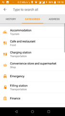
Examples of OSM POI categories supported in OsmAnd
Wherever OpenStreetMap POI categories are known to be rendered and/or searchable in OsmAnd, its corresponding key or tag page should indicate that OsmAnd supports it.
- food (bar, bbq, biergarten, cafe, drinking_water, fast_food, food_court, pub, restaurant)
- education (college, kindergarten, library, school, university)
- emergency (acces_point, ambulance_station, fire_extinguisher, fire_flapper, fire_hose, fire_hydrant, fire_station, phone, police, ses_station, siren)
- transportation (bicycle_parking, bicycle_rental, bus_station, car_rental, car_sharing, car_wash, ferry_terminal, fuel, grit_bin, parking, taxi)
- finance (atm, bank, bureau_de_change)
- healthcare (baby_batch, dentist, doctors, first_aid, hospital, pharmacy, veterinary)
- entertainment (architect_office, arts_centre, brothel, cinema, community_center, fountain, nightclub, sauna, stripclub, studio, theatre)
- tourism (alpine_hut, artwork, attraction, camp_site, caravan_site, chalet, guest_house, hostel, hotel, information, motel, museum, picnic_site, theme_park, viewpoint, zoo)
- historic (archaeological_site, battlefield, boundary_stone, castle, fort, memorial, monument, ruins, wayside_cross, wayside_shrine, wreck)
- natural (bay, beach, cave_entrance, cliff, coastline, fell, glacier, heath, land, marsh, mud, peak, sand, scree, scrub, spring, stone, tree, volcano, water, wetland)
- shop (alcohol, bakery, beauty, beverages, bicycle, books, boutique, butcher, car, car_repair, charity, chemist, clothes, computer, confectionery, department_store, doityourself, dry_cleaning, electronics, fabrics, farm, florist, funeral_directors, furniture, garden_centre, general, gift, glaziery, greengrocer, hairdresser, hardware, hearing_aids, hifi, ice_cream, jewelry, kiosk, laundry, mall, massage, money_lender, motorcycle, newsagent, optician, organic, outdoor, pawnbroker, second_hand, shoes, sports, stationary, supermarket, tattoo, toys, travel_agency, variety_store, video)
- leisure (common, dance, dog_park, fishing, garden, golf_course, ice_rink, nature_reserve, marina, miniature_golf, park, pitch, playground, sports_centre, slipway, stadium, track, water_park)
- sport (10pin, archery, athletics, australian_football, baseball, basketball, beachvolleyball, boules, bowls, canoe, chess, climbing, cricket, cricket_nets, croquet, cycling, diving, dog_racing, equestrian, football, golf, gymnastics, hockey, horse_racing, ice_stock, korfball, motor, multi, orienteering, paddle_tennis, paragliding, pelota, racquet, rowing, rugby, shooting, skateboard, skating, skiing, soccer, swimming, table_tennis, team_handball, tennis, toboggan, volleyball)
- other (bench, clock, courthouse, crematorium, embassy, emergency_phone, fire_hydrant, fire_station, grave_yard, hunting_stand, internet_access, marketplace, place_of_worship, police, post_box, post_office, prison, public_building, recycling, shelter, telephone, toilets, townhall, vending_machine, waste_basket, waste_disposal)
مشارکت در OSM با OsmAnd
OsmAnd از مشارکت مستقیم در پایگاه داده osm پشتیبانی میکند, هم بصورت آنلاین و هم بصورت آفلاین. اصلاحات یا فورا به سرور osm آپلود میشوند, یا در حالت آفلاین, باید بعدا بصورت دستی آپلود شوند.
اول, باید در سایت osm ثبت نام کنید.
بعد, در OsmAnd به قسمت Settings > Plugins رفته و پلاگین OSM Editing plugin را فعال کنید.
در آخر, به بخش Settings > OSM editing رفته و نام کاربری و کلمه عبور خود را وارد کنید.
برای اضافه کردن POI
- انگشت خود را روی بخشی که میخواهید نقطه مورد نظر را اضافه کنید بفشارید(hold ).
- پنجره خاکستری اطلاعات مکان ظاهر میشود و از سمت راست روی سه نقطه کلیک کنید تا منوی اضافی ظاهر شود.
- را انتخاب کنید "Create POI".
- اطلاعات مربوط به هر قسمت را وارد کنید. سایر بخش ها بصورت خودکار برای هر مقدار کلیدی در نظر گرفته میشود.
- اضافه کردن آدرس هنوز کمی سخت است ولی میتواند انجام شود.
- "Advanced Mode" را انتخاب کنید.
- "Add Tag را بفشارید".
- "A" را در قسمت tag تایپ کنید. شما نمی توانید تمام این تگ ها رو ببینید بنابراین لازم است که برای هر نقطه ای مقدار آن را به یاد داشته باشید.
- مقدار را وارد کنید.
- روی Commit کلیک کنید.
To record and submit GPX tracks
- Go to Settings > Plugins and activate the Record your trips plugin.
- Go to the map and press the button labeled GPX in the top-right corner of the screen, below the button with the satellite dish. This will start recording your trip.
- When you have finished your trip, press the button again to stop recording.
- Go to My Places > All Tracks.
- Find the recorded track, and click with a long press on it.
- Click Send to OSM.
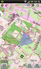
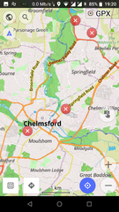
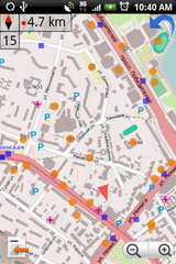
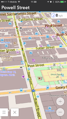
Screenshots
- OsmAnd for Android
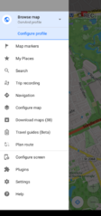
Main menu (Outdated)
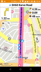
Car navigation
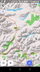
Touring view with Hillshades (Outdated)
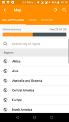
Download offline maps
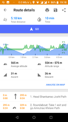
Route details
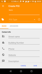
Choose/create POIs (offline)
Address search (offline)
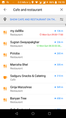
Nearby POI with opening hours
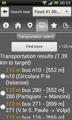
Public transport search
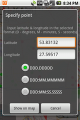
Show/go coordinates
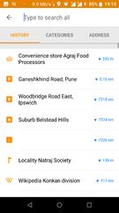
Search history
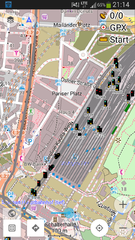
Railway signals from OpenRailwayMap as an overlay
Pedestrian mode with viewing-direction
See/edit OSM bugs
See/edit OSM POIs/transport over map


- OsmAnd for iOS
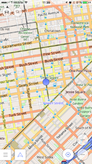
2D overview map
3D overview map

Search results


Customizing OsmAnd
Create your own maps
See the help topic How to prepare your own data to use offline and OsmAndMapCreator
Custom rendering style
OsmAnd already contains a number of specialized Map styles, from the map screen check them out by tapping the devices menu button, select "Define View", then "Configure screen", examples are the "Touring view" map style allowing some advanced options for options for hiking and bike tours, or the "Winter+ski" map style for skiing trips.
You may also define your own map style. This is a bit involved, please check out our forum, our HowTo pages, and start from the depends rendering template. Edit the file as you wish, rename it XXX.render.xml and place it on your device under /sdcard/osmand/rendering. Then in Osmand select XXX under "Map style".
Desktop Viewer for OsmAnd maps
An early version of a Desktop viewer for OsmAnd maps can be downloaded from Sourceforge: https://sourceforge.net/p/offroadosm/wiki/Home/
Resources and external links
- OsmAnd Home Page
- OsmAnd Google Groups Forum
- Issue Tracker
- Source code
- OsmAnd Local Indexes List: Links to .obf maps for download
- Using Osmand on the road: blog post about setting up Osmand on your smartphone
- Bicycle GPS project
- BBBike.org extract service offers OsmAnd maps for an area of your choosing, weekly updates