Featured images/Jul-Sep 2015
< Featured images(Redirected from Featured Images/Jul-Sep 2015)
Jump to navigation
Jump to search

These are featured images, which have been identified as the best examples of OpenStreetMap mapping, or as useful illustrations of the OpenStreetMap project.
If you know another image of similar quality, you can nominate it on Featured image proposals.
| ← from July to September 2014 | ← from April to June 2015 | from October to December 2015 → | from July to September 2016 → |
Gallery of featured images, from July to September 2015
2015, week 27
2015, week 28
2015, week 29
2015, week 30
2015, week 31
2015, week 32

2015, week 33

2015, week 34
2015, week 35
2015, week 36
2015, week 37
2015, week 38
2015, week 39
Details and captions
Week 27 (from Monday 29 June 2015 to Sunday 5 July 2015) [Edit]

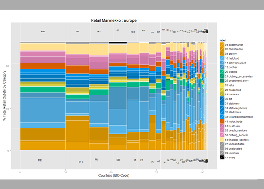
- English : User:SK53 has been investigating retail POI data, looking at the stats by country, and plotting this in a variety of ways. Read more on his blog post. This "Marimekko" diagram shows different retail types (shop tags) in different European countries.
Week 28 (from Monday 6 July 2015 to Sunday 12 July 2015) [Edit]

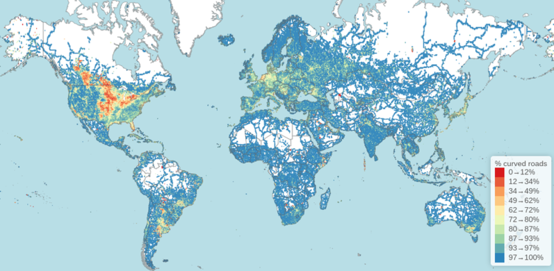
- English : Rory McCann analysed OpenStreetMap data to create this visualisation which answers the question "Where in the world has the straightest roads?
Week 29 (from Monday 13 July 2015 to Sunday 19 July 2015) [Edit]

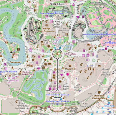
- English : Disneyland in California is celebrating its 60th anniversary this week. Kiosks, gardens and the routes of the roller-coasters, have all been mapped in glorious detail here on OpenStreetMap
Week 30 (from Monday 20 July 2015 to Sunday 26 July 2015) [Edit]

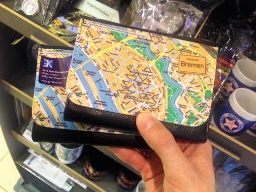
- English : This OpenStreetMap decorated wallet, manufactured by gerdkoch.de, was spotted on sale at the airport souvenirs shop in Bremen
Week 31 (from Monday 27 July 2015 to Sunday 2 August 2015) [Edit]

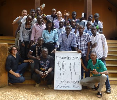
- English : Participants of the first West African State Of The Map (SOTM)! Organized at the Campus Numérique Francophone (CNF) in Ouagadougou, Burkina Faso last week. 20 mappers from 7 sub-region countries joined (Bénin, Burkina Faso, Côte d'Ivoire, Mali, Niger, Sénégal, Togo), within the context of a capacity-building mission from the Projet Espace OpenStreetMap Francophone (Projet EOF). See the SOTMBF conference program
Week 32 (from Monday 3 August 2015 to Sunday 9 August 2015) [Edit]

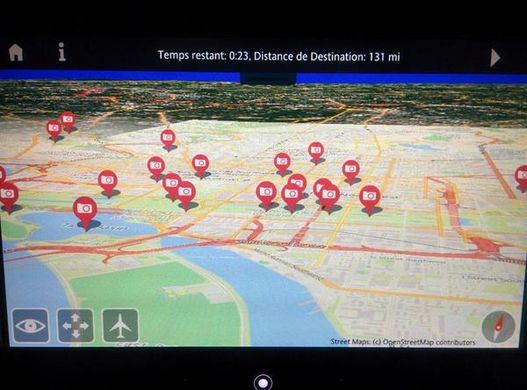
- English : Air France have an interactive 3D globe map view on their seatback displays, with maps from OpenStreetMap!
Week 33 (from Monday 10 August 2015 to Sunday 16 August 2015) [Edit]

- English : The London Hack Weekend took place last weekend, with developers coming together to work on a wide variety of technical projects, as well as celebrating the OpenStreetMap birthday!
Week 34 (from Monday 17 August 2015 to Sunday 23 August 2015) [Edit]

- English : Danny Goodayle experimented with OpenStreetMap data fed into the unity engine to create these and many more interesting city images
Week 35 (from Monday 24 August 2015 to Sunday 30 August 2015) [Edit]

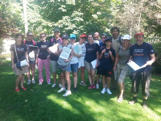
- English : A mapping party in Parque del Retiro in Madrid, adding details of historical monuments and botanical targets to the map
Week 36 (from Monday 31 August 2015 to Sunday 6 September 2015) [Edit]

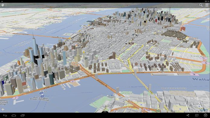
- English : OpenStreetMap building data in New York, New York. This was initially imported from NYC government datasets and has since been refined manually, to give more detailed shapes to many skyscrapers (ongoing). Viewed here with OSG-Maps the 3D data also looks great on osmbuildings.org, on F4 Map, and other 3D#Viewing software
Week 37 (from Monday 7 September 2015 to Sunday 13 September 2015) [Edit]

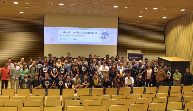
- English : State of the Map Latin America took place this weekend in Santiago, Chile
Week 38 (from Monday 14 September 2015 to Sunday 20 September 2015) [Edit]

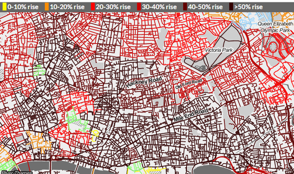
- English : Transport campaigning website howcongestedismyroad.org.uk shows traffic modelling data from Transport For London, snapped onto OpenStreetMap road network data and overlaid over Stamen's black & white toner style base-map
Week 39 (from Monday 21 September 2015 to Sunday 27 September 2015) [Edit]

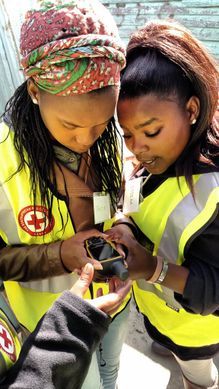
- English : Volunteers verifying their position. The American Red Cross recently ran a community mapping exercise in Khayelitsha, a large township in Cape Town, South Africa. Read more on this diary entry including ways you can help with the ongoing mapping work