Featured images/Jan-Mar 2014
Jump to navigation
Jump to search


These are featured images, which have been identified as the best examples of OpenStreetMap mapping, or as useful illustrations of the OpenStreetMap project.
If you know another image of similar quality, you can nominate it on Featured image proposals.
| ← from January to March 2013 | ← from October to December 2013 | from April to June 2014 → | from January to March 2015 → |
Gallery of featured images, from January to March 2014

2014, week 1
2014, week 2
2014, week 3
2014, week 4
2014, week 5

2014, week 6

2014, week 7
2014, week 8

2014, week 9

2014, week 10
2014, week 11

2014, week 12
2014, week 13
Details and captions
Week 1 (from Monday 30 December 2013 to Sunday 5 January 2014) [Edit]

- English : At CrisisCamp DC last month lots of people got involved in editing OpenStreetMap for Typhoon Haiyan crisis response.
Week 2 (from Monday 6 January 2014 to Sunday 12 January 2014) [Edit]

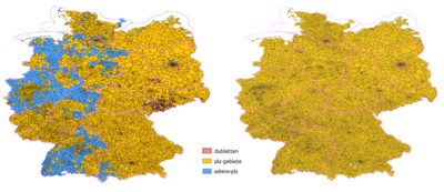
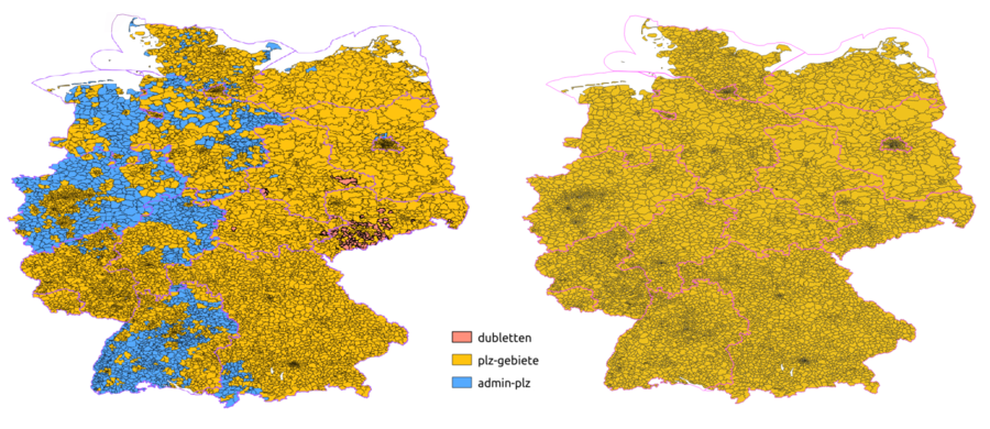
- English : In the last few weeks the German postal code areas were consolidated and checked: Before (left map) some postalcodes were tagged on admin boundary relations and duplicates existed. After (right map) all 8201 postalcode areas in Germany have their own postal_code relation. See the project page (in German).
Week 3 (from Monday 13 January 2014 to Sunday 19 January 2014) [Edit]

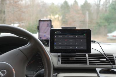
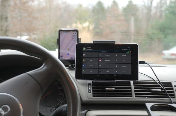
- English : A car dashboard kitted out with gadgets. This is just one of a wide variety of mapping techniques. Visible here (left to right): A smartphone running OsmAnd (information and map display) and a tablet computer set up with OSMtracker (POI recording).
Week 4 (from Monday 20 January 2014 to Sunday 26 January 2014) [Edit]

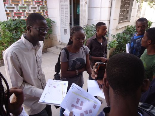
- English : The OpenSteetMap community in Senegal is growingǃ A lot of activities, training and presentations are happening these days. This photo shows architecture students during a surveying training session with Walking Papers printouts and GPS devices in Dakar.
Week 5 (from Monday 27 January 2014 to Sunday 2 February 2014) [Edit]

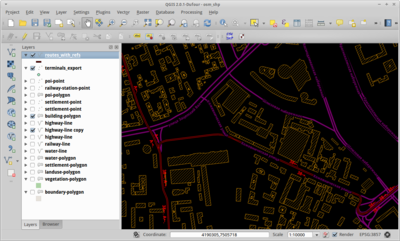
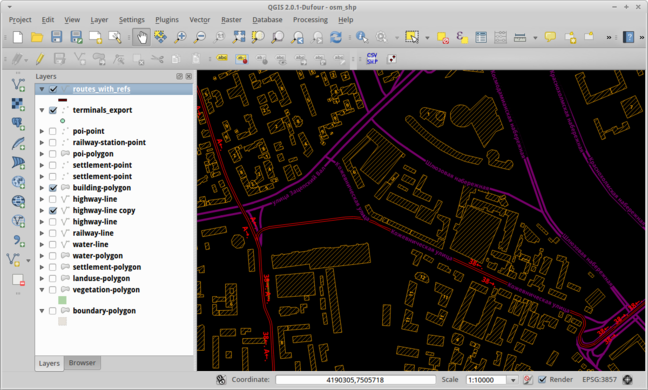
- English : Viewing OpenStreetMap buildings and tram data within the open source QGIS software.
Week 6 (from Monday 3 February 2014 to Sunday 9 February 2014) [Edit]

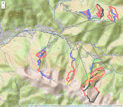
- English : The 2014 Olympics ski venues in the Krasnaya Polyana (Sochi) mountain cluster. This spontaneous mashup using Leaflet shows OpenSnowMap's ski pistes and lifts on OpenTopoMap as baselayer on a slippy map.
Week 7 (from Monday 10 February 2014 to Sunday 16 February 2014) [Edit]

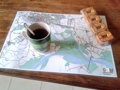
- English : A map of Pavia in Italy, rendered in high resolution using Maperitive, printed, laminated and used as a personal breakfast mat
Week 8 (from Monday 17 February 2014 to Sunday 23 February 2014) [Edit]

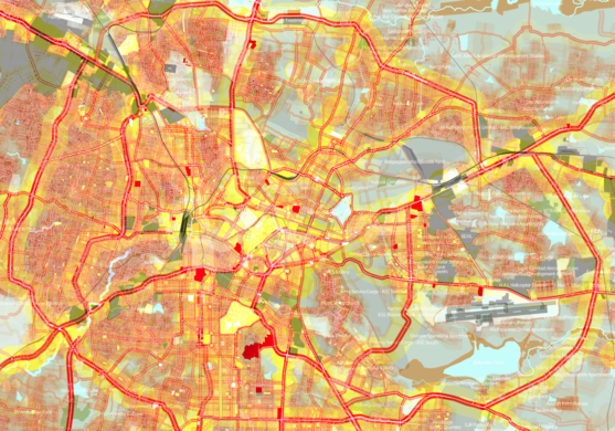
- English : Street network and built-up area of Bangalore (India). This colourful map was made based on OSM data using TileMill.
Week 9 (from Monday 24 February 2014 to Sunday 2 March 2014) [Edit]

- English : Forty people gathered for an event in Managua, Nicaragua, working on improving the OSM data including public transportation, neighbourhoods and important POIs
Week 10 (from Monday 3 March 2014 to Sunday 9 March 2014) [Edit]

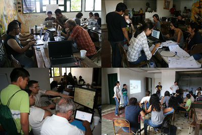
- English : 1st “OpenStreetMap Workshop from scratch” – a free and open event that brought together artists, cartographers, marketing companies and territorial planning/computer science students as part of the activities of the HackLabCocha in Cochabamba, Bolivia. View the full set of photos.
Week 11 (from Monday 10 March 2014 to Sunday 16 March 2014) [Edit]

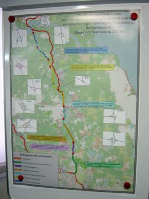
- English : A map of the “Sortavala” highway in Russia, on display at the road construction company offices. This poster has an OSM base map, and also inset details of road junctions based on the OpenStreetMap contributors data.
Week 12 (from Monday 17 March 2014 to Sunday 23 March 2014) [Edit]

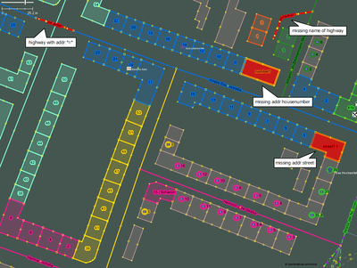
- English : This new "Coloured Streets" mappaint style makes working with addresses easier within JOSM. Addresses are given the same colour as the streets they are assigned to.
Week 13 (from Monday 24 March 2014 to Sunday 30 March 2014) [Edit]

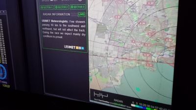
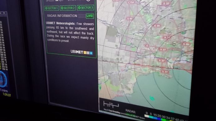
- English : OSM used as a backdrop on the weather radar for the Formula One Grand Prix at Melbourne. (TV photo)