Featured images/Oct-Dec 2012
Jump to navigation
Jump to search


These are featured images, which have been identified as the best examples of OpenStreetMap mapping, or as useful illustrations of the OpenStreetMap project.
If you know another image of similar quality, you can nominate it on Featured image proposals.
| ← from October to December 2011 | ← from July to September 2012 | from January to March 2013 → | from October to December 2013 → |
Gallery of featured images, from October to December 2012

2012, week 40

2012, week 41
2012, week 42

2012, week 43
2012, week 44
2012, week 45
2012, week 46
2012, week 47

2012, week 48

2012, week 49

2012, week 50
2012, week 51
2012, week 52
Details and captions
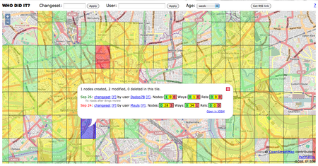
Week 40 (from Monday 1 October 2012 to Sunday 7 October 2012) [Edit]

- English : A screenshot of the WhoDidIt tool over London.
Week 41 (from Monday 8 October 2012 to Sunday 14 October 2012) [Edit]

- English : Karlsruhe Hack Weekend October 2012
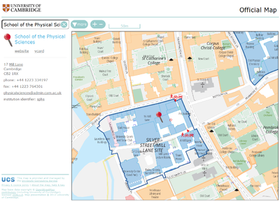
Week 42 (from Monday 15 October 2012 to Sunday 21 October 2012) [Edit]

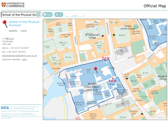
- English : The University of Cambridge's new online map was made live at http://map.cam.ac.uk in late September 2012 (and also linked from the University's home page). This prestigious, year-long project has contributed lots of data to OSM and uses OSM data for its street index and custom renderings. More...
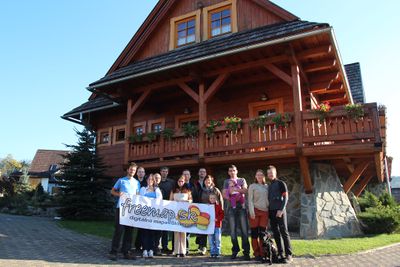
Week 43 (from Monday 22 October 2012 to Sunday 28 October 2012) [Edit]

- English : Slovak OpenStreetMap community having mapping party in Braväcovo. freemap.sk is an OpenStreetMap community site for Slovakia
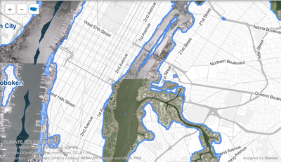
Week 44 (from Monday 29 October 2012 to Sunday 4 November 2012) [Edit]

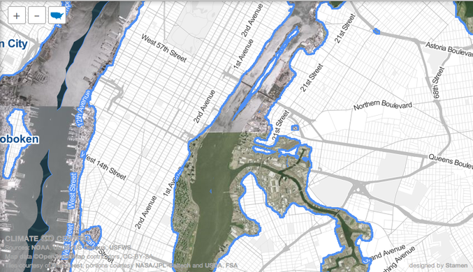
- English : The "Surging Seas" map blends OpenStreetMap and aerial imagery to interactively simulate sea level rise due to climate change. Here we see New York after a 10ft rise, the maximum setting. The storm surge of Hurricane Sandy brought a rise of up to 13ft.
Week 45 (from Monday 5 November 2012 to Sunday 11 November 2012) [Edit]

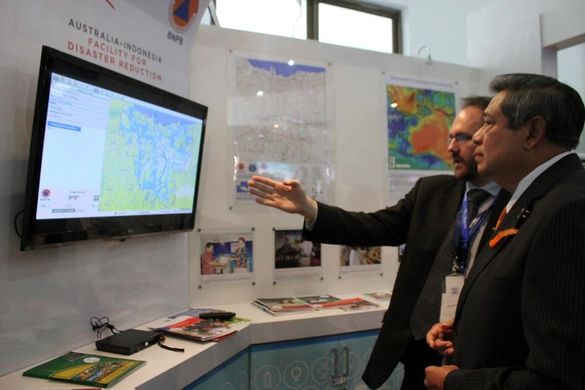
- English : Trevor Dhu from AusAID demonstrates flood impact in Jakarta with InaSAFE to President Susilo Bambang Yudhoyono at the 5th Asian Ministerial Conference on Disaster Risk Reduction . One of the key sets of information used in the analysis is OpenStreetMap data
Week 46 (from Monday 12 November 2012 to Sunday 18 November 2012) [Edit]

- English : The NoName map has been re-launched, showing an up-to-date view of where OpenStreetMap roads have no name
Week 47 (from Monday 19 November 2012 to Sunday 25 November 2012) [Edit]

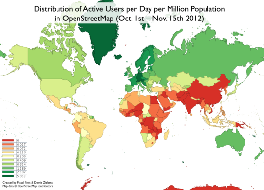
- English : Pascal Neis and Dennis Zielstra have come up with some wonderful statistics showing the distribution of the OSM contributors relative to population.
Week 48 (from Monday 26 November 2012 to Sunday 2 December 2012) [Edit]

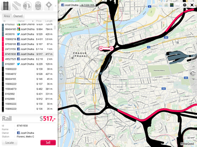
- English : A new game called Train Lord is using OSM for worldwide rail network coverage.
Week 49 (from Monday 3 December 2012 to Sunday 9 December 2012) [Edit]

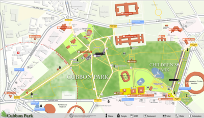
- English : Pedestrian Map for Cubbon park, Bangalore, created as part of a class project at NID. Students developed a system of navigation and wayfinding for visitors to the park. Data was collected using Walking Papers, added to OpenStreetMap, and then exported and processed in Adobe Illustrator for the final output.
Week 50 (from Monday 10 December 2012 to Sunday 16 December 2012) [Edit]

- English : London Hack Weekend the first weekend in December 2012. Writeup by Harry Wood.
Week 51 (from Monday 17 December 2012 to Sunday 23 December 2012) [Edit]

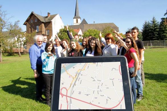
- English : Students and teachers from five countries meet in Saarburg, Germany to learn how to gather data, use mapping devices, feed in and maintain the OSM data. Meetings in Portugal, Slovenia, Romania and Turkey will follow as part of this two year EU funded Comenius project
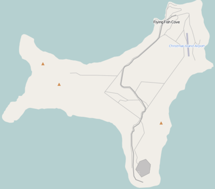
Week 52 (from Monday 24 December 2012 to Sunday 30 December 2012) [Edit]

- English : OSM map of Christmas Island.