Ferrara, Italy/Numeri civici
About
This page talks about importing addresses using the data provided by the Municipality of Ferrara (Italy).
The import has been discussed on the Italian OSM mailing list. This wiki page is the result of consensus there.
Goals
This import goal is to use the dataset provided by the Municipality of Ferrara in order to steadily improve the addresses available in OSM. It will not be a blind import, all data will be edited by a local mapper.
Address format in Ferrara
House numbering in Ferrara follows the European scheme.
An address in Ferrara is determined by its streetname and housenumber.
A housenumber is also unique per street.
Housenumbers can include a subordinate. These are noted with suffix letters (e.g. in "7a", "a" is the subordinate). Subordinates usually arise when a new house is build between existing houses with subsequent housenumbers. E.g. when a house is build between numbers 7 and 9, the new house will most likely get number 7a (since even numbers are reserved for the other side).
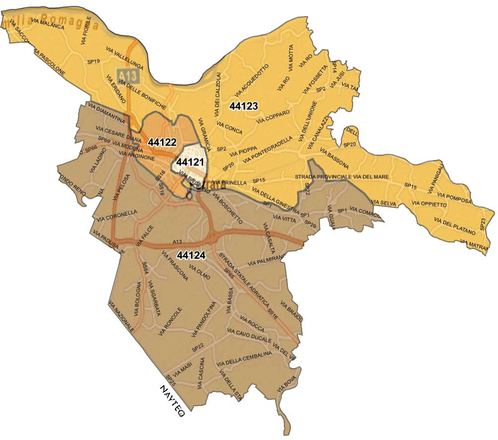
The postal codes boundary is not the same as the municipal boundary and therefore it has to be manually added: "44121" for the inner centre, "44122", "44123" and "44124" for the out-of-the-walls city, according to the Ferrara C.A.P. map.
Legal
Data source site: http://www.comune.fe.it/index.phtml?id=3513#nulla
Data license: http://www.comune.fe.it/index.phtml?id=3507
Type of license: IODL v2.0
OSM attribution: http://wiki.openstreetmap.org/wiki/Contributors#Ferrara
ODbL Compliance verified: not yet
From the IODL 2.0 license (in Italian): "indicare la fonte delle Informazioni e il nome del Licenziante, includendo, se possibile, una copia di questa licenza o un collegamento (link) ad essa."
Translation: "state the data source and the licensor name, including, if possible, a copy of this License or a connection (link) to it."
It should be enough to add the attribution in the Contributors page, like already done for Venice but, since this is an early version of this wiki page, it's ok to wait for other contributors to ask for their point of view.
Import Type
The original dataset is not very good in quality, so it will be used just as a layer to look at, in a process of manually creating the address points. If anyone is able to create a script to rectify everything, that would be the best, but it's probably impossible.
Mappers are invited to use the shapefile just as a layer, in order to compare data coming from personal experience to the actual layer.
Data Preparation
Tagging Plans
The data is presented as a shapefile. This shapefile consists in a collection of punctual elements, one for each housenumber.
Each node has the keys:
- ID_VIA: a unique numeric identifier for street
- ID_CIV: a unique numeric identifier for housenumber
- NUMERO: housenumber without subordinate
- ESPONENTE: the subordinate
- VIA_NOME_U: street name
The tags that will be used are addr:housenumber, addr:street, addr:postcode and addr:city.
The tags will be as follows:
- addr:housenumber will contain NUMERO followed by ESPONENTE converted to lowercase (for subordinates).
- addr:street will contain the street name in VIA_NOME_U but normalized to follow Italian conventions.
- addr:postcode will not be present because it is missing the original data source. These data will be later added manually.
- addr:city will contain "Ferrara".
Changeset Tags
Changeset will be tagged with source=Comune di Ferrara.
Data Transformation
Andrea Musuruane's script converts the dataset in a .osm file.
Workflow
There can be two options: 1) .osm file can be divided in many subsets, to be checked and aligned before import 2) import all the .osm file with a "fixme" tag for each node. So the community can correct, add postcode and so on, till no node will have the fixme tag.