Fi:Key:mtb:scale
| Kuvaus |
|---|
| Polkujen luokittelu maastopyöräilyn vaativuustasojen mukaan |
| Ryhmä: Ominaisuudet |
| Käytetään karttakohteille |
| Hyödyllisiä tagiyhdistelmiä |
| Tila: hyväksytty |
| Työkalut tälle tagille |
Perustelu
Erilaiset maastopyöräilyyn soveltuvat polut ja tiet voidaan asettaa vaativuustasoltaan keskenään järjestykseen, ja tämä vaativuusluokitus halutaan tallentaa globaalisti yhdenmukaisella tavalla karttatietoihin. Kuitenkin, koska vaativuustaso ylämäkeen polkijalle on eri kuin alamäen suuntaan, vaativuustaso ylämäen suuntaan täytyy merkitä erikseen - ellei polku ole lähes tasaisessa maastossa.
Lisää maastopyöräilijöitä mahdollisesti kiinnostavia ominaisuuksia on ehdotettu (englanniksi) sivulla Mountainbike.
Soveltuvat polut
Kartoitus
Ensisijainen tagi on mtb:scale arvoilla 0 .. 6. Tällä tagilla merkataan tasaisen maaston polun vaativuustaso, tai rinteessä olevalle polulle polun vaativuustaso alamäen suuntaan ajettaessa.
Jos vaativuustaso ylämäkeen polkevalle pyöräilijälle poikkeaa tästä arvosta, käytetään tagia mtb:scale:uphill=* arvoilla 0 .. 5. Jos vaativuustaso ylämäen suuntaan on merkitty erikseen, on toivottavaa merkata myös incline=* tagilla rinteen jyrkkyys ja ylä-/alamäen suunta kartalla.
Jos on riittävät tiedot polkujen luokitteluun tässä määriteltyjä luokkia tarkemmin, voidaan arvon perään lisätä "+" tai "-" merkkaamaan vaativuustason vaativamman pään polkuja. Esimerkiksi mtb:scale=1+ polulle, joka on muita arvon "1" polkuja vaativampi, mutta ei aivan täytä mitään vaativuustason "2" kriteeriä.
Tagia mtb:scale käytetään pääsääntöisesti vain poluille. Arvon tulisi määräytyä pidemmän pätkän yleisen vaativuuden perusteella, eli polulla voi olla muutamia kohtia joissa vaativuustaso on korkeampi. Tällaiset tulisi toistaiseksi merkata tällä samalla tagilla polun pisteelle vaativamman kohdan sijainnissa, ellei polkua ole muusta syystä katkottu omaksi polukseen lyhyellä vaativammalla osuudella.
Vaativammat yksittäiset kohdat
In order to highlight spots on a way, that feature a difficulty that is clearly more difficult than the way in general (e.g. one full grade more difficulty), on can highlight them by placing a node on the way with the difficulty to clear that node (do not highlight every switchback of a way however). If you put a point with mtb:scale=1-6 (0 makes no sense) outside of the way, then this shows a place that is more difficult, but can be circumvented.
mtb:scale=0-6
Ensisijainen luokitusasteikko
| Tagi | Kuvaus | Suurin sallittu jyrkkyys | STS vastaavuus | Esimerkkikuva |
|---|---|---|---|---|
| mtb:scale=0 | Gravel or packed earth. No particular difficulties. Mostly forest and meadow paths (highway=path). Sections with steps, rocks, or roots are not expected. Wide curves, easy to moderate slope. No special skills are needed to ride this. Easy to ride uphill.
For very easy ways you can use mtb:scale=0- for harder ones (but not yet mtb:scale=1) mtb:scale=0+ |
- | S0 | 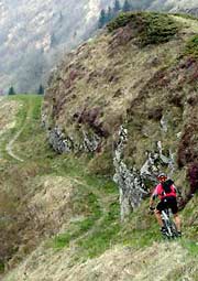
|
| mtb:scale=1 | Smaller obstacles like roots and small stones. Erosion damage may increase difficulty. Soil may be loose in places. Tight turns, but no hairpin turns. Riding requires care and attention, but no special skill. Obstacles can be ridden over. Difficult to ride uphill.
|
<40% | S1 | 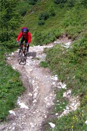
|
| mtb:scale=2 | Obstacles such as large rocks and stones. Soil is often loose. Steps are expected. Wider hairpin turns, steepness of up to 70%. Requires some advanced riding skills. Only very skilled riders can go uphill on this.
|
<70% | S2 | 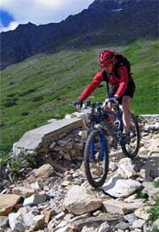
|
| mtb:scale=3 | Many sections with large obstacles such as boulders and large roots. Many hairpin and off-balance turns. Slippery surface and talus sections may be found. The surface may be very slippery. Constant concentration and very good skills needed. Nearly impossible to ride uphill.
|
>70% | S3 | 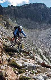
|
| mtb:scale=4 | Very steep and difficult, with sections having large boulders and roots. Frequent loose debris. Very steep sections with very tight hairpin turns and high steps that will cause the chainring to hit the ground. Some trials techniques will be necessary. Nearly impossible to ride uphill.
|
- | S4 | 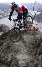
|
| mtb:scale=5 | Very steep and difficult with big boulder fields and debris, and landslides. Speed must be carried for counter-ascents. If at all only short passages are available for accelerating and braking. Fallen trees may make very steep passages even more difficult. Very few Mountainbikers can actually ride at this level. Most will have to push.
|
- | S5 | 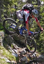
|
| mtb:scale=6 | Classify ways with 6 that are not rideable at all for a mtbiker. E.g. Chains or stemples (metal rungs) on a via ferrata or simply unsecured alpine pathes that are not even partly rideable for the very best mtbikers (using trial techniques). Steepness is often >45°.
If used for single points, then this highlights exceptionally difficult spots. Often spotting is impossible and falling may be lethal.
|
- |
mtb:scale:uphill=0-5
In the case you want to be more specific about the difficulty for going uphill. Please don't forget to also use the Key:incline on such ways so that routing software can make the way oneway. Especially for mtb:scale:uphill=4 and mtb:scale:uphill=5.
| Tag | Description | Average incline | Maximum incline | Obstacles |
|---|---|---|---|---|
| mtb:scale:uphill=0 | Graveled or hardened earth. Good Grip. Usually a highway=track. Even unskilled mountainbikers can ride up here easily. Cars with good tire clearance can go down or up without problems. | <10% | <15% | None |
| mtb:scale:uphill=1 | Graveled or hardened earth. Good Grip so wheelspin (also when standing) does not happen when taking care. Steep forest track or easy to ride footpath. | <15% | <20% | Some loose objects may lay on the trail but are avoidable |
| mtb:scale:uphill=2 | Mostly stable, unsurfaced, partly washed out, steady pedalling and ballance needed. With good technique and reasonable fitness this should be still doable however. | <20% | <25% | Fistsize loose rocks, roots or rocky underground |
| mtb:scale:uphill=3 | Variable Surface, tight corners, small steps, surface is rocks, earth or gras. Very good ballance and steady, round pedalling needed. Without very good skills mtbikers have to push their bike uphill | <25% | <30% | Fistsize loose rocks, roots and branches or rocky surface |
| mtb:scale:uphill=4 | Way is very steep, or in bad condition for pedalling uphill. Steps, trees, roots and tight corners are present and even good and strong mountainbikers will have to push or carry their bike for parts of the way | <30% | <40% | Big loose rocks, big branches across the trail, rocky or loose surface |
| mtb:scale:uphill=5 | Way is too steep and/or difficult to ride uphill. We need this level for signalling to other mtbikers that on this part they have to push and carry the bike. | - | - | - |
Notes to Usage of the scales
Huomioita
- Taulukoissa yllä sarake "STS vastaavuus" viittaa saksalaiseen "Singletrail-Skala v1.4" -asteikkoon, luettavissa ulkopuolisella sivulla [1]; tämä luokittelu pohjautuu STS-asteikon kuvauksiin. Sivuilta löytyy enemmän esimerkkikuvia ja kuvausta eri vaativuustasoista.
- The example photos of the STS scales are from http://www.singletrail-skala.de/ and may be reused under cc-by-sa-2 or cc-by-sa-3.
- If you click on the STS Equivalency links, you are linked to the respective difficulty grades on www.singletrail-skala.de. There are more pictures for each scale to give a better visual impression about each grade.
- Huomioi, että mtb:scale=* kertoo vain polulla ajamisen vaativuudesta, ei pyöräilyn laillisuudesta kyseisellä polulla. Jos pyöräily on erityisesti kielletty, merkkaa myös bicycle=no.
Esimerkkejä
If only one condition is met, the respecting scale should be used. E.g.
- a way with gradient 50% has to be tagged mtb:scale=2 or higher. Additional to signal to everyone that this way is steep mtb:scale:uphill=5 is needed.
- a way with loose surface possible, small roots and stones that goes flat is still mtb:scale=1 and not lower mtb:scale=0. mtb:scale:uphill is not needed.
- a way with loose surface possible, small roots and stones that goes at an average incline of 25% is mtb:scale=1 and mtb:scale:uphill=3. This is a good example for a way that is quite easy to go down, but very difficult to go up.
mtb:scale:imba=0-4
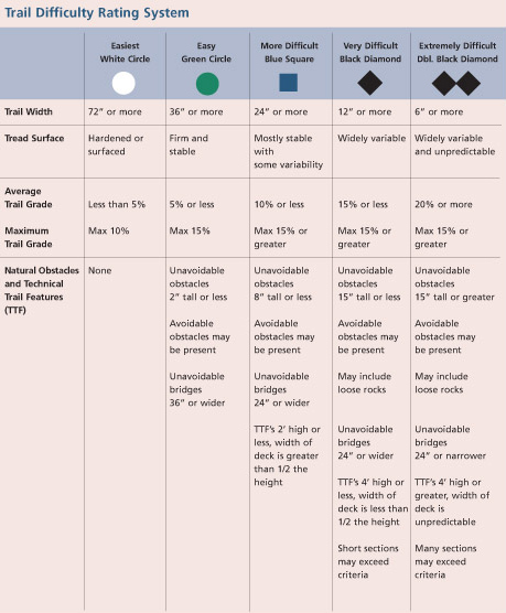
The IMBA Trail Difficulty Rating System shall be used for bikeparks. Especially for North Shore. It is adapted to mtb trails with artificial obstacles. For "natural" trails it is advised to use the mtb:scale/mtb:uphill:scale.
mtb:scale:imba= ... 0 .................... 1 ..................... 2 ..................... 3 ..................... 4 ....
Graphics reused with permission from IMBA.
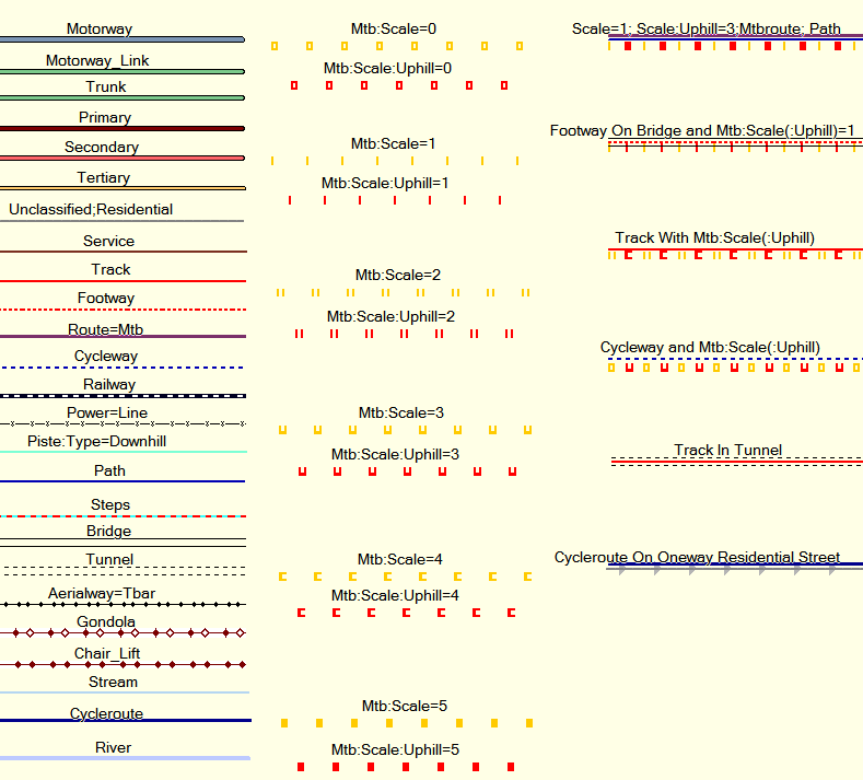
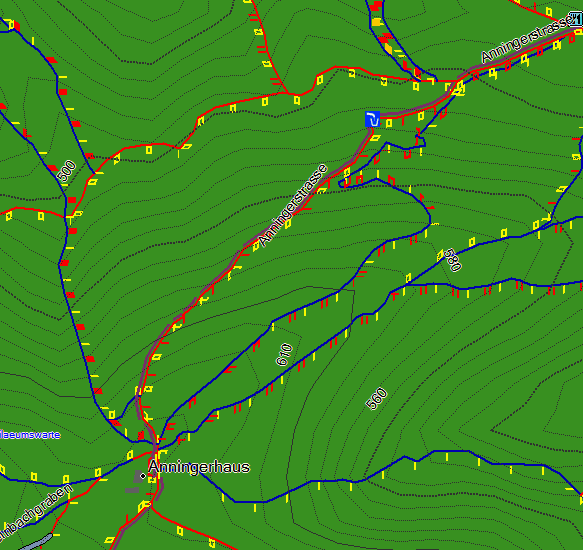
Example Rendering of the mtb:scale using Garmin Mapsource
See Also
- Approved_features/mtb:scale
- Mountain biking - General page on how to tag ways appropriate for mountain biking.
- sac_scale=* - a classification scheme for hiking trails
