File:Bajrabarahi Nepal mapping training.jpg
(Redirected from File:15876910152 c51d14acb9 z.jpg)
Jump to navigation
Jump to search

No higher resolution available.
Bajrabarahi_Nepal_mapping_training.jpg (400 × 300 pixels, file size: 40 KB, MIME type: image/jpeg)

This is a Featured image, which means that it has been identified as one of the best examples of OpenStreetMap mapping, or that it provides a useful illustration of the OpenStreetMap project. If you know another image of similar quality, you can nominate it on Featured image proposals.
Front-page image for week 7 of 2015 (9–15 Feb.).
- Image descriptions
- English : Local citizens from Bajrabarahi, Makwanpur, Nepal mapping their towns and villages. Kathmandu Living Labs, pioneer of OpenStreetMap in Nepal, was involved in training them. The training mostly focused on mapping agriculture and food security data
- français : Des cotoyens locaux de Bajrabarahi, Makwanpur, Nepal, carographiant leurs propres hameaux et villages. Kathmandu Living Labs, pionnier d'OpenStreetMap au Népal, a été impliqué dans leur entrainement. L'entrainement s'est principalement focalisé sur la cartographie de l'agriculture et des données de sécurité alimentaire.
- italiano : Residenti di Bajrabarahi, Makwanpur, Nepal che mappano le loro città e villaggi. Kathmandu Living Labs, pioniere di OpenStreetMap in Nepal, è stato incaricato di insegnargli, concentrandosi principalmente su dati riguardanti l'agricoltura e la sicurezza del cibo.
- русский : Жители непальского района Макванпур заняты улучшением облика своих городов и деревень в ОпенСтритМапе. Фотография сделана на тренинге, который организовали ребята из компании «Катманду-ливинг-мапс» — пионера ОСМ в Непале. В основном участники встречи занимались добавлением на карту сельскохозяйственных и продовольственных объектов.
- 中文(繁體) : 尼伯爾Makwanpur Bajrabarahi的公民畫他們生活的城鎮和村莊。尼伯爾在開放街圖的先驅-加德滿都Living Labs,參與其中訓練參與者。這次訓練主要著重在畫農業和糧食安全資料。
Licensing
![]()
![]()
![]()
This work is licensed under the Creative Commons Attribution-ShareAlike 2.0 License.
Attribution not specified as a parameter! THIS LICENSE ALWAYS REQUIRES ATTRIBUTION! Use {{CC-BY-SA-2.0|Attribution, typically name of author}} See Template:CC-BY-SA-2.0 for full description how this template should be used.
Note, there is
There is also
Attribution not specified as a parameter! THIS LICENSE ALWAYS REQUIRES ATTRIBUTION! Use {{CC-BY-SA-2.0|Attribution, typically name of author}} See Template:CC-BY-SA-2.0 for full description how this template should be used.
Note, there is
{{CC-BY-SA-2.0 OpenStreetMap}} for files based on old OSM map data, before the license change made on 2012-09-12.There is also
{{OSM Carto screenshot||old_license}} for files based on old OSM map data, before the license change made on 2012-09-12, created using OSM Carto map style.
File history
Click on a date/time to view the file as it appeared at that time.
| Date/Time | Thumbnail | Dimensions | User | Comment | |
|---|---|---|---|---|---|
| current | 08:55, 23 January 2015 | | 400 × 300 (40 KB) | Megha (talk | contribs) | |
| 08:33, 23 January 2015 | 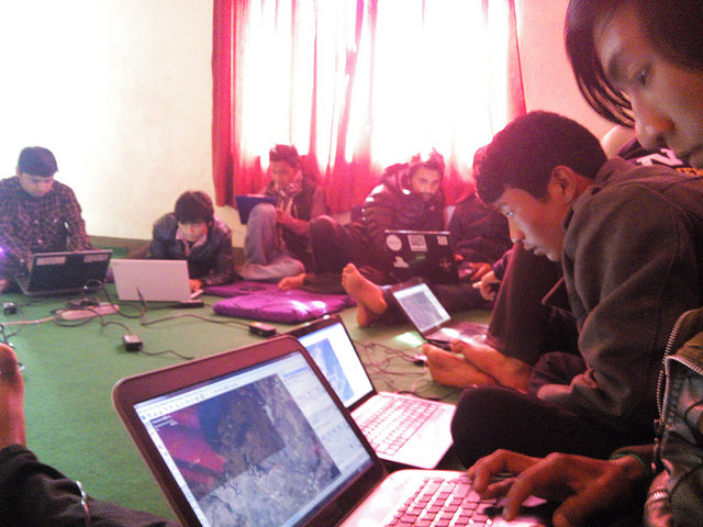 | 640 × 480 (105 KB) | Megha (talk | contribs) |
You cannot overwrite this file.
File usage
The following 9 pages use this file: