File:2013 GutauWandertafel.jpg
Jump to navigation
Jump to search


Size of this preview: 450 × 600 pixels. Other resolutions: 180 × 240 pixels | 360 × 480 pixels | 576 × 768 pixels | 768 × 1,024 pixels | 2,448 × 3,264 pixels.
Original file (2,448 × 3,264 pixels, file size: 3.08 MB, MIME type: image/jpeg)

Summary
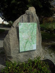
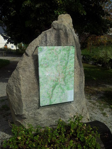
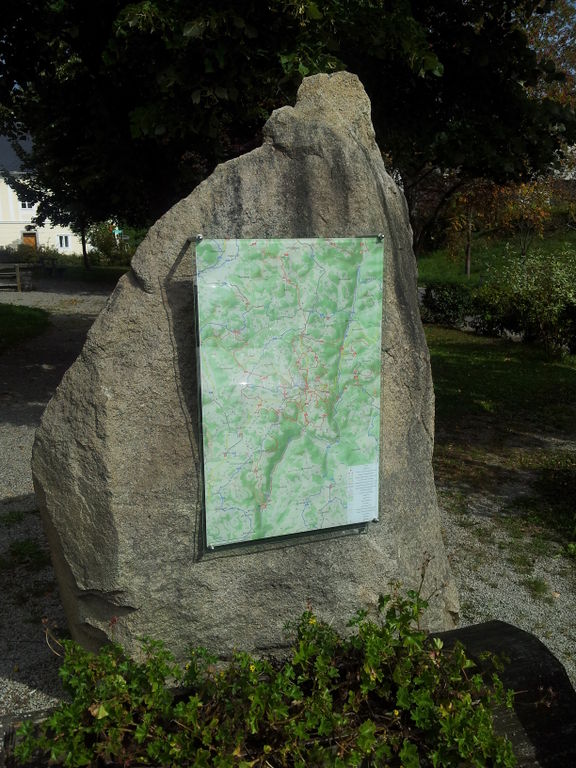
[English] Display board "hiking and bikeing" in Gutau, Austria, published 2013, made by User:Numenor
[Deutsch] Rad- und Wandertafel Gutau, Österreich, 2013, von User:Numenor
→ https://lorien.ancalime.de/gutau.html
This is a Featured image, which means that it has been identified as one of the best examples of OpenStreetMap mapping, or that it provides a useful illustration of the OpenStreetMap project. If you know another image of similar quality, you can nominate it on Featured image proposals.
Front-page image for week 42 of 2014 (13–19 Oct.).
- Image descriptions
- Deutsch : Auf einem Stein montierte Wanderkarte. Holger Schöner hat im Umkreis von Gutau (ein kleines Dorf in Oberösterreich) bereits einige Wander- und Radkarten in verschiedenen Formen erstellt. (mehr dazu (in seinem Blog))
- English : A walking map display board mounted on a rock. Holger Schöner has produced hiking and cycling maps in various forms around the area of Gutau (a small village in Upper Austria) Read more (in German)
- français : Une panneau de carte piétonne fixé à un rocher. Holger Schöner a produit des cartes de hiking et cyclisme de différents types dans les environs de Gutau (un petit village de Haute-[Autriche]]) en connaître d'avantage (en allemand)
- italiano : Un pannello con una mappa escursionistica montato su una roccia. Holger Schöner ha prodotto mappe escursionistiche e ciclistiche in varie forme nell'area di Gutau (un piccolo villaggio in Alta Austria). Ulteriori informazioni (in tedesco).
- русский : Эта карта неподалёку от австрийской деревни Гутау сделана Холгером Шонером. Размещённые на нескольких похожих стендах в округе, данные ОСМ помогают велосипедистам и пешеходам ориентироваться на местности.
- 中文(繁體) : 嵌在石頭上的行走指南地圖。Holger Schöner繪製不少古陶地區(奧地利上奧地利州的小鎮)不同型式的健行、單車地圖。詳情閱讀更多 (德文)
Licensing
![]()
![]()
![]()
This work is licensed under the Creative Commons Attribution-ShareAlike 2.0 License.
Attribution not specified as a parameter! THIS LICENSE ALWAYS REQUIRES ATTRIBUTION! Use {{CC-BY-SA-2.0|Attribution, typically name of author}} See Template:CC-BY-SA-2.0 for full description how this template should be used.
Note, there is
There is also
Attribution not specified as a parameter! THIS LICENSE ALWAYS REQUIRES ATTRIBUTION! Use {{CC-BY-SA-2.0|Attribution, typically name of author}} See Template:CC-BY-SA-2.0 for full description how this template should be used.
Note, there is
{{CC-BY-SA-2.0 OpenStreetMap}} for files based on old OSM map data, before the license change made on 2012-09-12.There is also
{{OSM Carto screenshot||old_license}} for files based on old OSM map data, before the license change made on 2012-09-12, created using OSM Carto map style.
File history
Click on a date/time to view the file as it appeared at that time.
| Date/Time | Thumbnail | Dimensions | User | Comment | |
|---|---|---|---|---|---|
| current | 04:03, 3 October 2014 | | 2,448 × 3,264 (3.08 MB) | Al. (talk | contribs) | [English] Display board "hiking and bikeing" in Gutau, Austria, published 2013, made by User:Numenor [Deutsch] Rad- und Wandertafel Gutau, Österreich, 2013, von User:Numenor → https://lorien.ancalime.de/gutau.html |
You cannot overwrite this file.
File usage
The following 7 pages use this file: