File:2014 Bolivian Floods Chapare Cochabamba 20140207 022405.png
Jump to navigation
Jump to search

No higher resolution available.
2014_Bolivian_Floods_Chapare_Cochabamba_20140207_022405.png (479 × 441 pixels, file size: 56 KB, MIME type: image/png)
Information
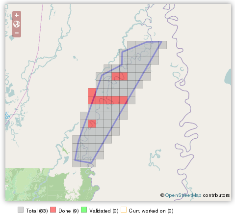
| Description | Tarea HOT Task 417 was created to map Chapare Zone in Cochabamba and the surrounding areas in response to Bolivian Floods. |
|---|---|
| Author | Screenshot by 51114u9 |
| Source | http://tasks.hotosm.org/job/417 |
| Date | 2014-02-07 |
| Permission | CC BY-SA 2.0 |
![]()
This media file does not have sufficient information on its copyright status. If you have created this file yourself, or the file is available under some open licence allowing its use on OSM Wiki or the file is in the public domain, you can edit the file description page to license it under one of the allowed licences. If you did not create it and it is not in the public domain, you must ask the copyright holder for permission to release it under one of the allowed licenses. Wiki:Media file license chart may be helpful to find a suitable licence.
Files without licences marked with this template are listed in Category:Media without a license or one of its subcategories. If the file is without a known open licence: ask its uploader to clarify situation or find a replacement and mark this file with {{Superseded by Commons}} and replace its uses.
Files without licences marked with this template are listed in Category:Media without a license or one of its subcategories. If the file is without a known open licence: ask its uploader to clarify situation or find a replacement and mark this file with {{Superseded by Commons}} and replace its uses.
If uploader was notified this month: use {{No licence|subcategory=uploader notified 2024, April}} - to put media into Category:Media without a license - uploader notified 2024, April and mark image as one where uploader was notified.
File history
Click on a date/time to view the file as it appeared at that time.
| Date/Time | Thumbnail | Dimensions | User | Comment | |
|---|---|---|---|---|---|
| current | 06:29, 7 February 2014 | | 479 × 441 (56 KB) | Smaug (talk | contribs) |
You cannot overwrite this file.
File usage
The following page uses this file: