File:Railway-station-tagging.svg
(Redirected from File:A-simple-station.svg)
Jump to navigation
Jump to search

Size of this PNG preview of this SVG file: 512 × 268 pixels. Other resolutions: 320 × 168 pixels | 640 × 335 pixels | 1,024 × 536 pixels | 1,280 × 670 pixels.
Original file (SVG file, nominally 512 × 268 pixels, file size: 391 KB)
Summary
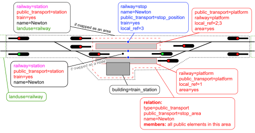
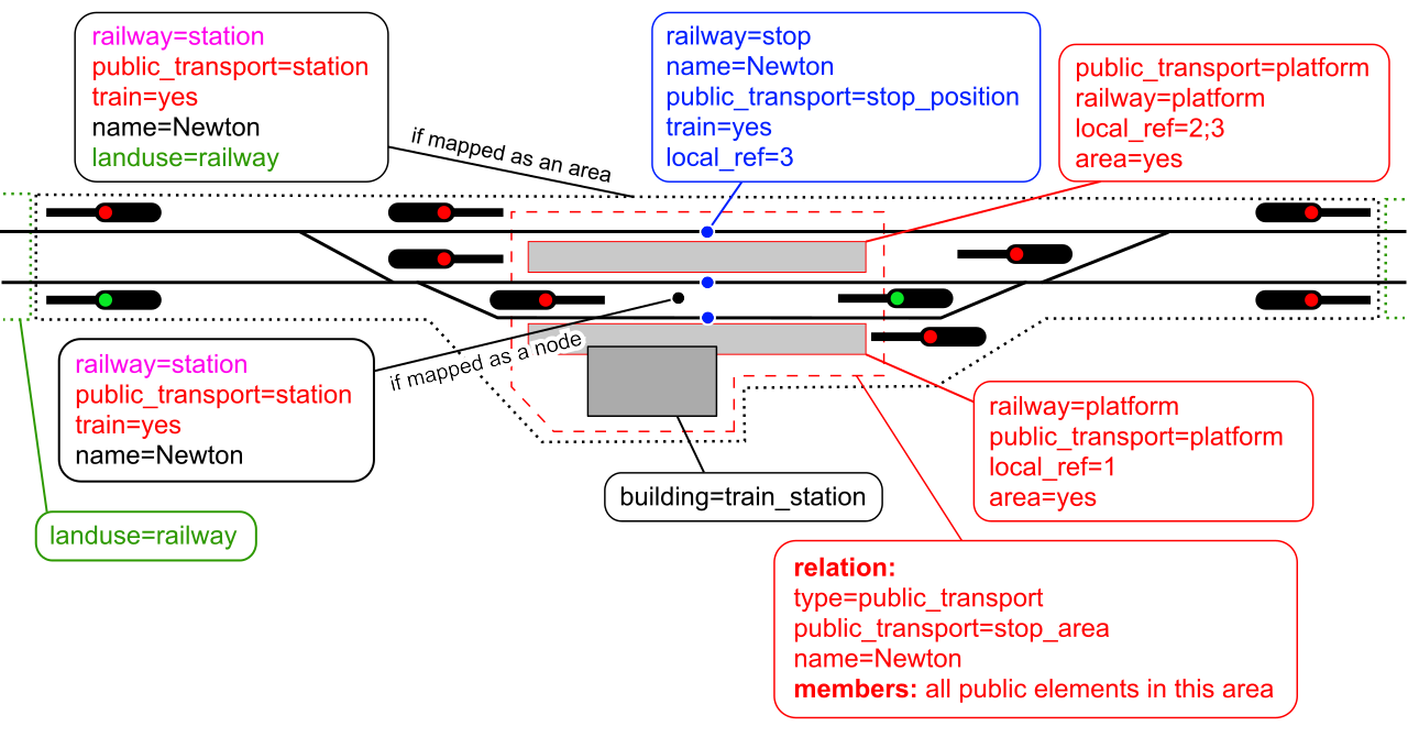
| Description | Tagging of a railway station. Red: public_transport=*; pink: railway=*; blue: route=train; green: landuse=* scheme. |
|---|---|
| Author | Nakaner, Dieterdreist, Gymate |
| Source | own work; community forum discussion: [1] |
| Date | 2015-01-24 |
| Other versions | Railway-station-tagging_simple.svg |
Licensing
![]()
![]()
![]()
This work is licensed under the Creative Commons Attribution-ShareAlike 4.0 License.
Attribution: Nakaner, Dieterdreist, Gymate
Attribution: Nakaner, Dieterdreist, Gymate
See also
- Russian version (discontinued): File:A-simple-station-ru.svg
- Alternative (unused) version
File history
Click on a date/time to view the file as it appeared at that time.
| Date/Time | Thumbnail | Dimensions | User | Comment | |
|---|---|---|---|---|---|
| current | 13:16, 26 March 2024 | | 512 × 268 (391 KB) | Gymate (talk | contribs) | Converted texts to outlines due to librsvg rendering them incorrectly (?) – use the previous version if you want to make edits |
| 13:15, 26 March 2024 |  | 512 × 268 (27 KB) | Gymate (talk | contribs) | Removed railway=facility relation; added missing train=yes tags | |
| 20:54, 15 January 2024 |  | 512 × 281 (459 KB) | Gymate (talk | contribs) | Converted texts to outlines due to librsvg rendering them incorrectly (?) – use the previous version if you want to make edits {{CC-BY-SA-4.0-self}} | |
| 20:54, 15 January 2024 |  | 512 × 281 (30 KB) | Gymate (talk | contribs) | Corrected 'objects' to 'elements' {{CC-BY-SA-4.0-self}} | |
| 10:55, 15 January 2024 |  | 512 × 281 (458 KB) | Gymate (talk | contribs) | Converted texts to outlines due to librsvg rendering them incorrectly (?) – use the previous version if you want to make edits {{CC-BY-SA-4.0-self}} | |
| 10:51, 15 January 2024 |  | 512 × 281 (30 KB) | Gymate (talk | contribs) | Put public_transport=station tag and node vs. area mapping back; modified tagging of relations; removed railway=halt tag {{CC-BY-SA-4.0-self}} | |
| 00:18, 23 November 2023 |  | 512 × 273 (344 KB) | Gymate (talk | contribs) | Converted text back to outlines due to librsvg rendering them incorrectly (?) – use previous version if you want to edit the file {{CC-BY-SA-4.0-self}} | |
| 21:50, 22 November 2023 |  | 512 × 273 (25 KB) | Gymate (talk | contribs) | Converted outlines to text (Arial), removed spaces in tags, modified as discussed here: [https://community.openstreetmap.org/t/railway-station-as-an-area/104839/24] {{CC-BY-SA-4.0-self}} | |
| 08:42, 15 May 2017 | 1,296 × 502 (203 KB) | Dieterdreist (talk | contribs) | add the area variant and convert remaining text to path (for consistency when missing the font) | ||
| 14:58, 4 October 2016 | 1,296 × 502 (70 KB) | Nakaner (talk | contribs) | add polygons with {{Tag|landuse|railway}} beyond the entry signals |
You cannot overwrite this file.
File usage
The following 44 pages use this file:
- Cs:Tag:railway=station
- GeOps/Trafimage Station Names
- Pl:Stacje kolejowe
- Pl:Tag:railway=station
- Railway stations
- Slovakia railways
- Tag:railway=station
- Uk:Tag:railway=station
- Uk:Залізничні станції
- Zh-hans:铁路车站
- User:Kubahaha/Pl:Tag:railway=station
- User:Nakaner/Tag:railway=station
- File:A-simple-station.svg (file redirect)
- ES:Directrices de etiquetado españolas
- DE:Tag:railway=station
- Railway stations
- JA:Tag:railway=station
- Uk:Залізничні станції
- Uk:Tag:railway=station
- FR:Gares ferroviaires
- RU:Железнодорожная станция
- RU:Tag:railway=station
- Pl:Stacje kolejowe
- User:Nakaner/Tag:railway=station
- Cs:Tag:railway=station
- IT:Stazioni ferroviarie
- DE:GeOps/Trafimage Station Names
- GeOps/Trafimage Station Names
- Pl:Tag:railway=station
- ES:Tag:railway=station
- ES:Estaciones de ferrocarril
- Zh-hans:铁路车站
- User:Kubahaha/Pl:Tag:railway=station
- Slovakia railways
- DE:GeOps/Trafimage Station Names
- DE:Tag:railway=station
- FR:Gares ferroviaires
- ES:Directrices de etiquetado españolas
- ES:Estaciones de ferrocarril
- ES:Tag:railway=station
- IT:Stazioni ferroviarie
- RU:Tag:railway=station
- RU:Железнодорожная станция
- JA:Tag:railway=station