File:Austrian Buildings Completeness Map.png
Jump to navigation
Jump to search


Size of this preview: 795 × 599 pixels. Other resolutions: 318 × 240 pixels | 637 × 480 pixels | 801 × 604 pixels.
Original file (801 × 604 pixels, file size: 825 KB, MIME type: image/png)
Summary
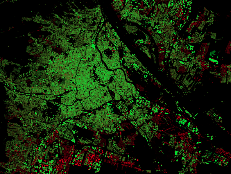
How complete are buildings in Austria?
Thomas Konrad compares buildings in OSM with basemap.at.
This image is a screenshot of the area around Wien (Vienna)
This is a Featured image, which means that it has been identified as one of the best examples of OpenStreetMap mapping, or that it provides a useful illustration of the OpenStreetMap project. If you know another image of similar quality, you can nominate it on Featured image proposals.
Front-page image for week 38 of 2014 (15–21 Sep.).
- Image descriptions
- Deutsch : Analyse der OSM-Gebäudeabdeckung in Österreich, verglichen mit der amtlichen basemap.at (grün ... vorhandene, rot ... fehlende Gebäude). Blog und Karte
- English : A striking dark-background rendering of OpenStreetMap building coverage (green) and those which are missing (red) as compared to basemap.at data in Austria. Blog post and slippy map
- italiano : Un suggestivo rendering su fondo nero della copertura degli edifici di OpenStreetMap (in verde) e di quelli che mancano (in rosso) in confronto ai dati di basemap.at in Austria. Blog e mappa interattiva.
- русский : Эта изящная визуализация показывает здания на карте Австрии. Зелёным отмечены дома, которые есть в ОСМ, а красным — места, где их пока не хватает. Данные сравниваются с государственным источником basemap.at. Подробности — в блоге.
- 中文(繁體) : 一張黑色背景,對比相當強烈的開放街圖建築物覆蓋情形 (綠色),而其他還未畫上去的建築 (紅色),用的是奧地利 basemap.at 的資料比對。 部落格文章和互動地圖
License
File history
Click on a date/time to view the file as it appeared at that time.
| Date/Time | Thumbnail | Dimensions | User | Comment | |
|---|---|---|---|---|---|
| current | 02:25, 8 September 2014 | | 801 × 604 (825 KB) | Harry Wood (talk | contribs) | How complete are buildings in Austria? Thomas Konrad compares buildings in OSM with basemap.at. [http://thomaskonrad.at/2014/08/analyse-der-openstreetmap-gebaudeabdeckung-in-osterreich/ blog post] This image is a screenshot of the area around Wein |
You cannot overwrite this file.
File usage
The following 8 pages use this file: