File:Battlegrid screenshot.png
Jump to navigation
Jump to search


No higher resolution available.
Battlegrid_screenshot.png (753 × 511 pixels, file size: 604 KB, MIME type: image/png)
Description
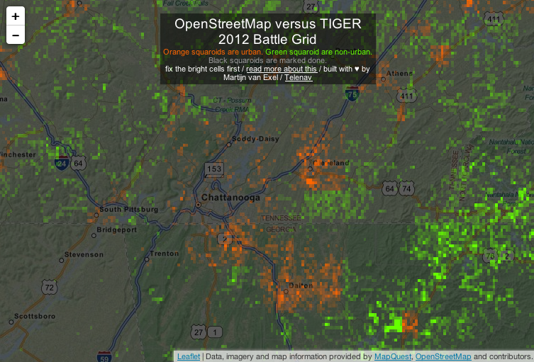
Screenshot of TIGER Battlegrid centered on Chattanooga http://maproulette.org/battlegrid/#9/35.1222/-85.0397
This is a Featured image, which means that it has been identified as one of the best examples of OpenStreetMap mapping, or that it provides a useful illustration of the OpenStreetMap project. If you know another image of similar quality, you can nominate it on Featured image proposals.
Front-page image for week 39 of 2013 (23–29 Sep.).
- Image descriptions
- Deutsch : Die TIGER-Battlegrid-Karte zeigt (mittels Vergleich mit den neueren TIGER-2012-Daten) ein farbiges Indikatorraster (orange für städtischen und grün für ländlichen Raum) für jene Teile der USA, wo mehr TIGER-Reparaturarbeit nötig ist. Mehr dazu ist in diesem Blogeintrag beschrieben.
- English : The TIGER Battlegrid map shows colourful grid squares (orange for urban, green for countryside) for parts of the U.S. where more TIGER fixup work is needed by comparing with the newer TIGER 2012 data. Read more on this blog post
- español : El TIGER Battlegrid muestra un mapa colorido mediante una cuadricula (naranja para la zona urbana, verde para zonas rurales) para partes de los EUA. Donde se necesita trabajo de reparación TIGER, comparándolo con los datos más recientes de TIGER 2012. Lea más sobre esta entrada en el blog.
- italiano : La mappa TIGER Battlegrid mostra una griglia di quadrati colorati (arancione per la città, verde per la campagna) per le parti degli Stati Uniti dove serve più lavoro di correzione dei dati TIGER confrontando i nuovi dati TIGER 2012. Maggiori informazioni in questo blog (in inglese).
- Nederlands : De TIGER Battlegrid-kaart laat met gekleurde vakjes zien in welke delen van de VS nog TIGER-opruimwerk nodig is, door te vergelijken met de nieuwere TIGER-2012-gegevens (oranje voor steden, groen voor het platteland) Lees meer op deze blogpost.
- русский : Карта TIGER Battlegrid показывает места в США, где следует исправить или перепроверить ОСМ в соответствии с новыми данными от государства (TIGER 2012 года). Оранжевые территории — города, зелёные — сельская местность. Подробности — в заметке от автора.
- 中文(简体) : TIGER Battlegrid地图以色彩滨纷的方格子(橘色代表都会区,而绿色代表乡间) 显示部分的美国,其中TIGER 图资与TIGER 2012 年资料比较,需要修正人力。 详情请阅读这篇部落格文章
- 中文(繁體) : TIGER Battlegrid地圖以色彩濱紛的方格子 (橘色代表都會區,而綠色代表鄉間) 顯示部分的美國,其中 TIGER 圖資與 TIGER 2012 年資料比較,需要修正人力。詳情請閱讀這篇部落格文章
License
see File talk:Battlegrid screenshot.png (at least regarding the background map)
File history
Click on a date/time to view the file as it appeared at that time.
| Date/Time | Thumbnail | Dimensions | User | Comment | |
|---|---|---|---|---|---|
| current | 08:58, 23 September 2013 | | 753 × 511 (604 KB) | Harry Wood (talk | contribs) | Screenshot of TIGER Battlegrid centered on Chattanooga http://maproulette.org/battlegrid/#9/35.1222/-85.0397 |
You cannot overwrite this file.