File:Br-classificacao-bento-goncalves-rs-plano-diretor.jpg
Jump to navigation
Jump to search


Size of this preview: 365 × 599 pixels. Other resolutions: 146 × 240 pixels | 292 × 480 pixels | 1,023 × 1,678 pixels.
Original file (1,023 × 1,678 pixels, file size: 378 KB, MIME type: image/jpeg)
Summary
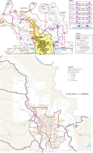
Classificação oficial segundo o plano diretor, publicada em 29 de outubro de 2015.
Disponível oficialmente no site da Prefeitura em:
- Planos Municipais > Plano de Mobilidade Urbana 2015 > Anexos da Lei 5996, em:
- Anexo 2.5 Vias Coletoras de Tráfego - VCT
- Anexo 9 - Mapa de vias para circulação do transporte coletivo urbano
- Neste link direto, em:
- Neste link direto ou neste link direto, em Anexo 4 - Sistema Viário
- Neste link direto, em Proposta Anexo 4.0 ME - Sistema Viário Rural
Licensing
![]()
This file has been released into the public domain by the copyright holder, its copyright has expired, or it is ineligible for copyright. This applies worldwide.
Please, please use more specific template such as {{PD-self}} / {{PD-creator}} / {{PD-shape}} / {{PD-USGov}} / {{PD-old}} / {{PD-RU-exempt}} ... This template is not making clear why this work is in the public domain.
Please, please use more specific template such as {{PD-self}} / {{PD-creator}} / {{PD-shape}} / {{PD-USGov}} / {{PD-old}} / {{PD-RU-exempt}} ... This template is not making clear why this work is in the public domain.
File history
Click on a date/time to view the file as it appeared at that time.
| Date/Time | Thumbnail | Dimensions | User | Comment | |
|---|---|---|---|---|---|
| current | 21:45, 2 October 2015 | | 1,023 × 1,678 (378 KB) | Ftrebien (talk | contribs) | Atualizado sistema viário urbano, disponível temporariamente no site da [http://www.bentogoncalves.rs.gov.br/ Prefeitura] em [http://www.bentogoncalves.rs.gov.br/pagina/revisao-do-plano-diretor Revisão do Plano Diretor] > [http://www.bentogoncalves.... |
| 21:40, 2 October 2015 |  | 1,023 × 2,223 (514 KB) | Ftrebien (talk | contribs) | Classificação oficial segundo o plano diretor, publicada em 6 de fevereiro de 2012. Disponível oficialmente no site da [http://www.bentogoncalves.rs.gov.br/ Prefeitura] em [http://www.bentogoncalves.rs.gov.br/pagina/plano-diretor Plano Diretor] > [... |
You cannot overwrite this file.
File usage
The following page uses this file: