File:Br-classificacao-brazlandia-df-plano-diretor.jpg
Jump to navigation
Jump to search

Size of this preview: 634 × 599 pixels. Other resolutions: 254 × 240 pixels | 508 × 480 pixels | 963 × 910 pixels.
Original file (963 × 910 pixels, file size: 141 KB, MIME type: image/jpeg)
Summary
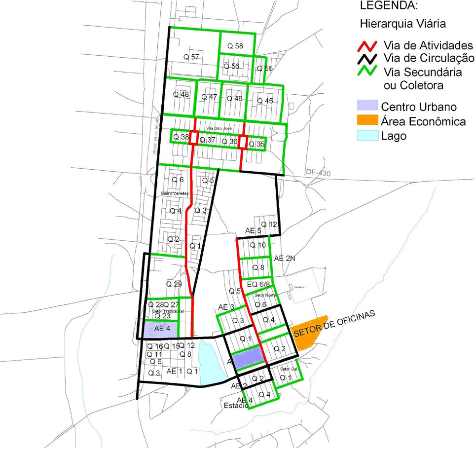
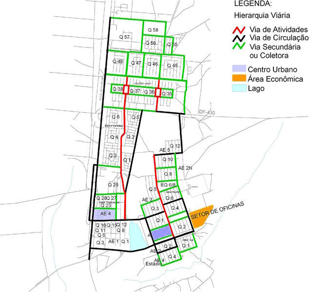
Classificação oficial segundo o plano diretor, publicada em 17 de outubro de 2012.
Disponível oficialmente no site do Governo > Secretarias > Gestão do Território e Habitação > Portal da Secretaria do Estado de Gestão do Território e Habitação > Planejamento Urbano > Plano Diretor de Ordenamento Territorial > Processo de Atualização - PDOT 2009 > Lei Complementar nº 854 de 15 de outubro de 2012 > Lei Complementar 854 > Anexo V - Hierarquia Viária e Setorização - Brazlândia - RA IV (página 24).
Licensing
![]()
This file has been released into the public domain by the copyright holder, its copyright has expired, or it is ineligible for copyright. This applies worldwide.
Please, please use more specific template such as {{PD-self}} / {{PD-creator}} / {{PD-shape}} / {{PD-USGov}} / {{PD-old}} / {{PD-RU-exempt}} ... This template is not making clear why this work is in the public domain.
Please, please use more specific template such as {{PD-self}} / {{PD-creator}} / {{PD-shape}} / {{PD-USGov}} / {{PD-old}} / {{PD-RU-exempt}} ... This template is not making clear why this work is in the public domain.
File history
Click on a date/time to view the file as it appeared at that time.
| Date/Time | Thumbnail | Dimensions | User | Comment | |
|---|---|---|---|---|---|
| current | 06:30, 7 October 2015 | | 963 × 910 (141 KB) | Ftrebien (talk | contribs) | Classificação oficial segundo o plano diretor, publicada em 17 de outubro de 2012. Disponível oficialmente no site do [http://www.df.gov.br/ Governo] > [http://www.df.gov.br/sobre-o-governo/estrutura/secretarias.html Secretarias] > [http://www.sege... |
You cannot overwrite this file.
File usage
The following page uses this file: