File:Br-classificacao-porto-alegre-rs-plano-diretor.jpg
Jump to navigation
Jump to search
Size of this preview: 408 × 599 pixels. Other resolutions: 163 × 240 pixels | 327 × 480 pixels | 1,022 × 1,500 pixels.
Original file (1,022 × 1,500 pixels, file size: 338 KB, MIME type: image/jpeg)
Summary
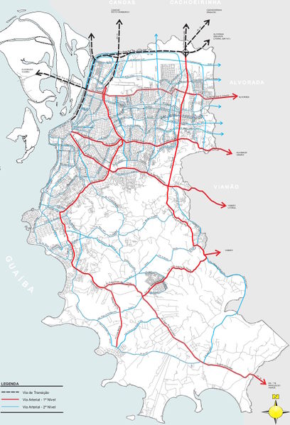
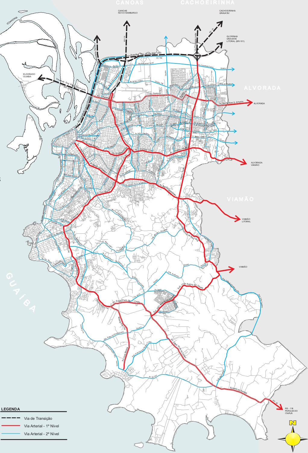
Classificação oficial segundo o plano diretor (PDDUA), publicada em 6 de março de 2012.
Disponível oficialmente no site da Prefeitura em Urbanismo > Plano Diretor > Anexos > 9 - Classificação das Vias e Perfis Viários > Anexo 9 > Anexo 9.3: malha viária básica, classificação e hierarquização (página 437). Para ter mais qualidade, a imagem (com informação idêntica à original) foi obtida desta fonte em Anexo 9.3: malha viária básica, classificação e hierarquização (página 10).
Licensing
![]()
This file has been released into the public domain by the copyright holder, its copyright has expired, or it is ineligible for copyright. This applies worldwide.
Please, please use more specific template such as {{PD-self}} / {{PD-creator}} / {{PD-shape}} / {{PD-USGov}} / {{PD-old}} / {{PD-RU-exempt}} ... This template is not making clear why this work is in the public domain.
Please, please use more specific template such as {{PD-self}} / {{PD-creator}} / {{PD-shape}} / {{PD-USGov}} / {{PD-old}} / {{PD-RU-exempt}} ... This template is not making clear why this work is in the public domain.
File history
Click on a date/time to view the file as it appeared at that time.
| Date/Time | Thumbnail | Dimensions | User | Comment | |
|---|---|---|---|---|---|
| current | 20:28, 30 September 2015 | | 1,022 × 1,500 (338 KB) | Ftrebien (talk | contribs) | Classificação oficial segundo o plano diretor (PDDUA). Disponível oficialmente no site da [Prefeitura http://www2.portoalegre.rs.gov.br/] em Plano Diretor > [http://www2.portoalegre.rs.gov.br/spm/default.php?reg=24&p_secao=218 Anexos] > [http://lpr... |
You cannot overwrite this file.
File usage
The following page uses this file: