File:Canoe Mapping - La Boquilla Project.jpg
Jump to navigation
Jump to search


Size of this preview: 800 × 600 pixels. Other resolutions: 320 × 240 pixels | 640 × 480 pixels | 1,024 × 768 pixels | 1,200 × 900 pixels.
Original file (1,200 × 900 pixels, file size: 246 KB, MIME type: image/jpeg)
Summary
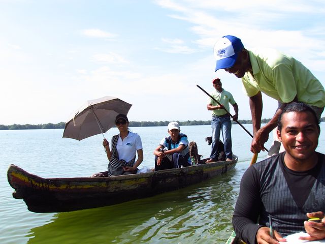
Canoe Mapping in the mangroves. La Boquilla, Cartagena, Colombia. In a diary entry by Humberto Yances he describes his participatory mapping project involving the local community, fishermen and ecotourism associations. Follow-up workshops resulted in a map, and ongoing work on "Social Innovation for Mangrove Conservation".
Image released to the public domain by permission from Humberto Yances
Licensing
![]()
This file has been released into the public domain by the copyright holder, its copyright has expired, or it is ineligible for copyright. This applies worldwide.
Please, please use more specific template such as {{PD-self}} / {{PD-creator}} / {{PD-shape}} / {{PD-USGov}} / {{PD-old}} / {{PD-RU-exempt}} ... This template is not making clear why this work is in the public domain.
Please, please use more specific template such as {{PD-self}} / {{PD-creator}} / {{PD-shape}} / {{PD-USGov}} / {{PD-old}} / {{PD-RU-exempt}} ... This template is not making clear why this work is in the public domain.
This is a Featured image, which means that it has been identified as one of the best examples of OpenStreetMap mapping, or that it provides a useful illustration of the OpenStreetMap project. If you know another image of similar quality, you can nominate it on Featured image proposals.
Front-page image for week 21 of 2013 (20–26 May).
- Image descriptions
- Deutsch : Kanu-Mapping in den Mangroven. La Boquilla, Cartagena, Kolumbien. In einem Tagebucheintrag von Humberto Yances beschreibt er seine partizipativen Mapping-Projekt unter Einbeziehung der örtlichen Gemeinschaft, Fischer und Ökotourismus Verbände. Workshops führte zu einer Karte und zu laufenden Arbeiten zum Thema "Soziale Innovation für Mangrove Conservation".
- English : Canoe Mapping in the mangroves. La Boquilla, Cartagena, Colombia. In a diary entry by Humberto Yances he describes his participatory mapping project involving the local community, fishermen and ecotourism associations. Follow-up workshops resulted in a map, and ongoing work on "Social Innovation for Mangrove Conservation"
- français : Cartographie en canoë dans les mangroves à La Boquilla, Carthagène des Indes, Colombie.. dans une entrée du journal par Humberto Yances, il décrit un projet de cartographie participative impliquant la communauté locale, des pêcheurs et des associations d'écotourisme. Les ateliers qui suivirent aboutirent en une carte et un travail à venir à propos de l'« Innovation sociale pour la conservation de la mangrove ».
- italiano : Mappatura in canoa tra le mangrovie. La Boquilla, Cartagena, Colombia. Nel suo diario, Humberto Yances, descrive il suo progetto di mappatura partecipativa che coinvolge la comunità locale, pescatori e associazioni di ecoturismo. Dei workshop successivi hanno prodotto una mappa e ulteriore lavoro sul tema "Social Innovation for Mangrove Conservation"
- Nederlands : "Kano-mappen" in een mangrovebos, in La Boquilla, Cartagena, Colombia. In een dagboek-verhaal beschrijft Humberto Yances zijn project met de lokale gemeenschap, vissers en ecotoeristen. De volgende workshops leverden een kaart op, en werk aan "sociale innovatie voor het behoud van mangroves"
- 中文(简体) : 哥伦比亚卡塔赫纳La Boquilla 红树林的小舟探察绘图。 Humberto Yances 撰写的日记,详细介绍他与在地社区、渔夫和生态旅游协会一同参与的绘图专案。后续的工作坊成果有地图,以及接续的行动"为红树林保育而社会革新(Social Innovation for Mangrove Conservation)"
- 中文(繁體) : 哥倫比亞卡塔赫納 La Boquilla 紅樹林的小舟探察繪圖。Humberto Yances 撰寫的日記,詳細介紹他與在地社區、漁夫和生態旅遊協會一同參與的繪圖專案。後續的工作坊成果有地圖,以及接續的行動"為紅樹林保育而社會革新 (Social Innovation for Mangrove Conservation)"
File history
Click on a date/time to view the file as it appeared at that time.
| Date/Time | Thumbnail | Dimensions | User | Comment | |
|---|---|---|---|---|---|
| current | 10:40, 17 May 2013 | | 1,200 × 900 (246 KB) | Harry Wood (talk | contribs) | == Summary == Canoe Mapping in the mangroves. La Boquilla, Categena, Colombia. In a [http://www.openstreetmap.org/user/Humberto_Yances/diary diary entry by Humberto Yances] he describes his participatory mapping project involving the local community, f... |
You cannot overwrite this file.
File usage
The following 6 pages use this file: