File:Br-classificacao-pelotas-rs-plano-diretor.png
(Redirected from File:Classificacao-pelotas-rs-plano-diretor-2009-06-05.png)
Jump to navigation
Jump to search
Size of this preview: 318 × 598 pixels. Other resolutions: 127 × 240 pixels | 255 × 480 pixels | 408 × 768 pixels | 1,024 × 1,927 pixels.
Original file (1,024 × 1,927 pixels, file size: 1.65 MB, MIME type: image/png)
Summary
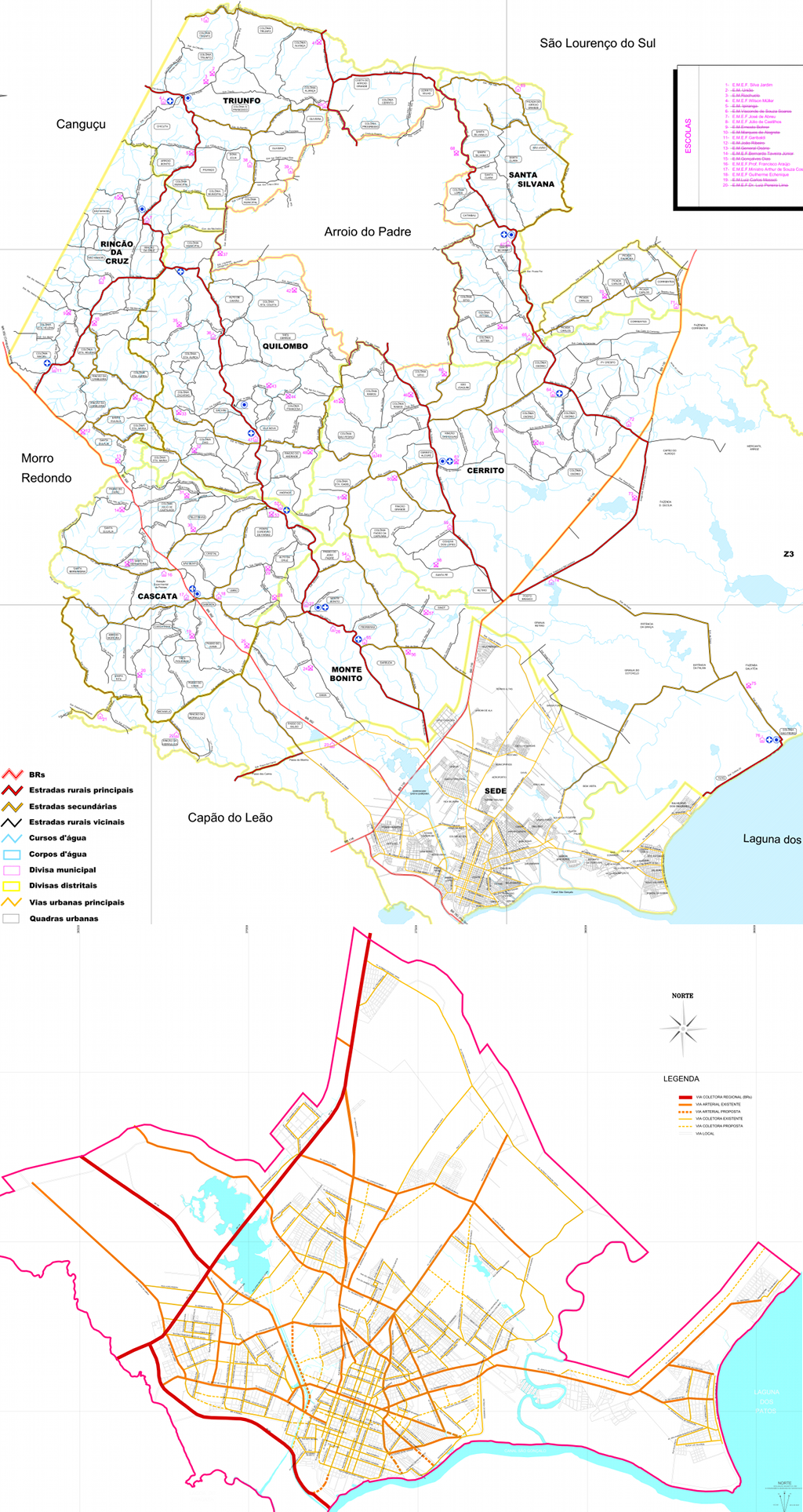
Classificação oficial segundo o plano diretor, publicada em 22 de dezembro de 2008 (escala urbana) e 5 de junho de 2009 (escala municipal).
Disponível oficialmente no site da Prefeitura em Planejamento > Gestão Urbana > III Plano Diretor > Lei do III Plano Diretor > Mapas +, em:
- Escala Municipal > Sistema Viário e Equipamentos Públicos
- Escala Urbana > Sistema Viário - Hierarquia
Licensing
![]()
This file has been released into the public domain by the copyright holder, its copyright has expired, or it is ineligible for copyright. This applies worldwide.
Please, please use more specific template such as {{PD-self}} / {{PD-creator}} / {{PD-shape}} / {{PD-USGov}} / {{PD-old}} / {{PD-RU-exempt}} ... This template is not making clear why this work is in the public domain.
Please, please use more specific template such as {{PD-self}} / {{PD-creator}} / {{PD-shape}} / {{PD-USGov}} / {{PD-old}} / {{PD-RU-exempt}} ... This template is not making clear why this work is in the public domain.
File history
Click on a date/time to view the file as it appeared at that time.
| Date/Time | Thumbnail | Dimensions | User | Comment | |
|---|---|---|---|---|---|
| current | 04:51, 2 October 2015 | | 1,024 × 1,927 (1.65 MB) | Ftrebien (talk | contribs) | Classificação oficial segundo o plano diretor, publicada em 22 de dezembro de 2008 (escala urbana) e 5 de junho de 2009 (escala municipal). Disponível oficialmente no site da [http://www.pelotas.rs.gov.br/ Prefeitura] em [http://www.guaiba.rs.gov.b... |
You cannot overwrite this file.
File usage
The following 2 pages use this file: