File:Dachformen.pdf
Jump to navigation
Jump to search
Size of this JPG preview of this PDF file: 424 × 599 pixels. Other resolutions: 170 × 240 pixels | 339 × 480 pixels | 543 × 768 pixels | 724 × 1,024 pixels | 1,550 × 2,191 pixels.
Original file (1,550 × 2,191 pixels, file size: 925 KB, MIME type: application/pdf)
![]()
The 3D Development team are currently working on unifying 3D related tags.
For first results see Simple 3D Buildings.
For first results see Simple 3D Buildings.
Summary
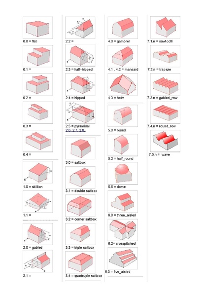
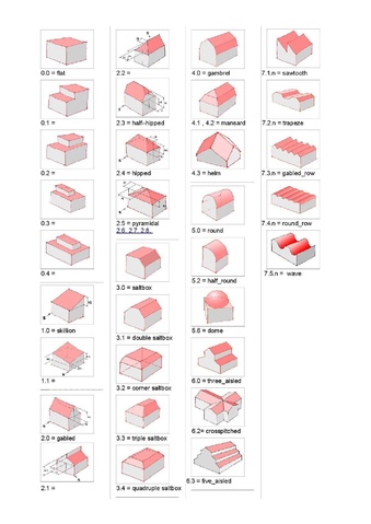
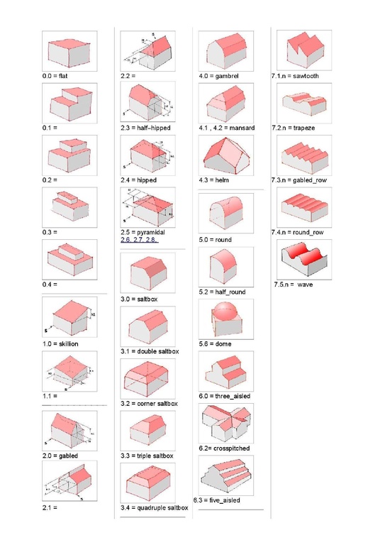
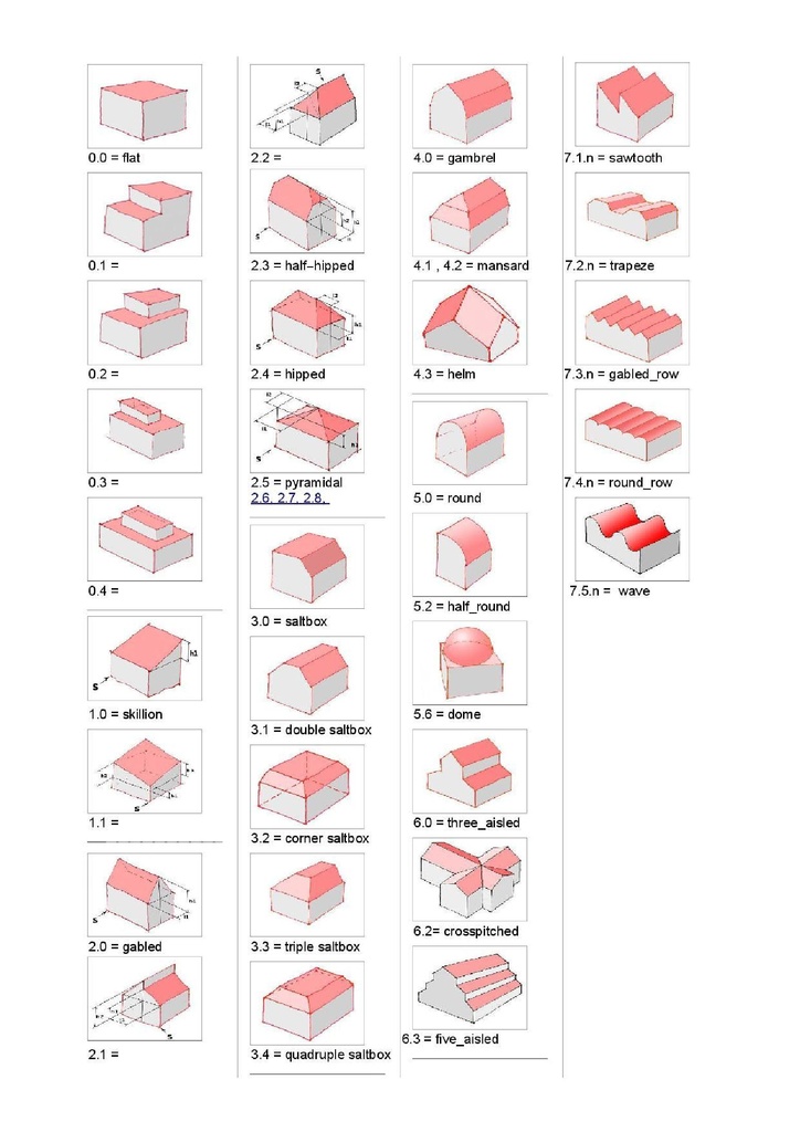
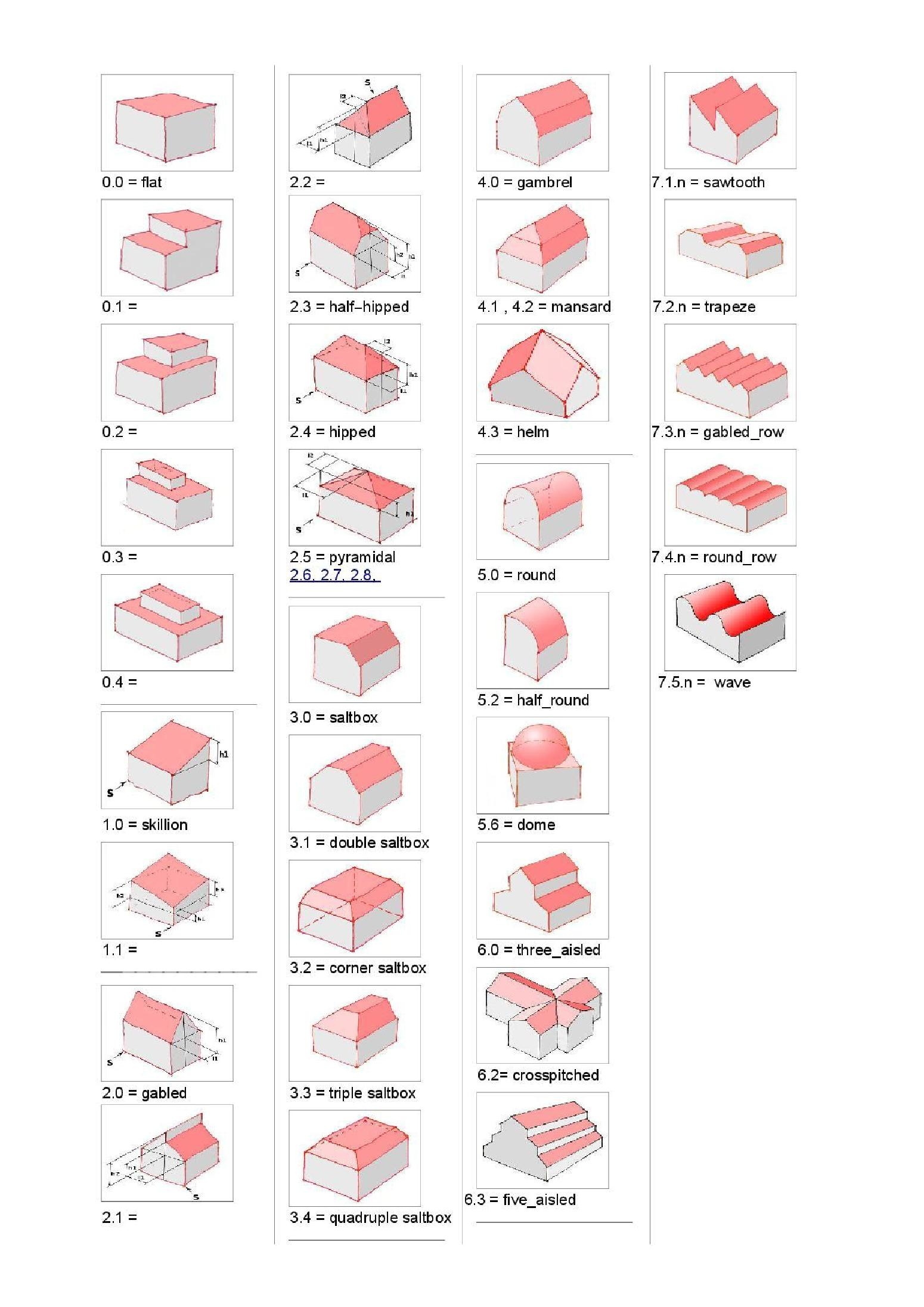
Bezogen wird sich auf die Seite http://wiki.openstreetmap.org/wiki/DE:Roof_table .
Zur Datenerfassung für Gebäude in 3D existieren Zahlen- und Wortwerte. Diese werden mit dieser Tabelle veranschaulicht und können als Tagginggrundlage genutzt werden.
Licensing
![]()
This file has been released into the public domain by the copyright holder, its copyright has expired, or it is ineligible for copyright. This applies worldwide.
Please, please use more specific template such as {{PD-self}} / {{PD-creator}} / {{PD-shape}} / {{PD-USGov}} / {{PD-old}} / {{PD-RU-exempt}} ... This template is not making clear why this work is in the public domain.
Please, please use more specific template such as {{PD-self}} / {{PD-creator}} / {{PD-shape}} / {{PD-USGov}} / {{PD-old}} / {{PD-RU-exempt}} ... This template is not making clear why this work is in the public domain.
File history
Click on a date/time to view the file as it appeared at that time.
| Date/Time | Thumbnail | Dimensions | User | Comment | |
|---|---|---|---|---|---|
| current | 13:39, 29 July 2019 |  | 1,550 × 2,191 (925 KB) | Geri-oc (talk | contribs) | Reverted to version as of 13:25, 29 July 2019 (UTC) |
| 13:28, 29 July 2019 |  | 1,550 × 2,191 (951 KB) | Geri-oc (talk | contribs) | https://forum.openstreetmap.org/viewtopic.php?id=66907 | |
| 13:25, 29 July 2019 |  | 1,550 × 2,191 (925 KB) | Geri-oc (talk | contribs) | half_hipped -> half-hipped -> https://forum.openstreetmap.org/viewtopic.php?id=66907 | |
| 18:37, 7 December 2011 | 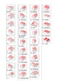 | 1,239 × 1,754 (518 KB) | Geri-oc (talk | contribs) | Schreibfehler korr. | |
| 15:27, 7 December 2011 | 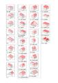 | 1,239 × 1,754 (518 KB) | Geri-oc (talk | contribs) | - Dachformen mit Stand vom 07.12.2011 - Verlinkung geändert: Bilder zum Thema - Spezielle, abweichende Dachformen sind eventuell im Thema vorhanden - Soweit building_attributes gesetzt - siehe Vergleichstabelle - übernommen. | |
| 18:16, 5 December 2011 | 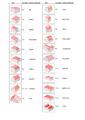 | 1,239 × 1,754 (618 KB) | Geri-oc (talk | contribs) | Bezogen wird sich auf die Seite http://wiki.openstreetmap.org/wiki/DE:Roof_table . Zur Datenerfassung für Gebäude in 3D existieren Zahlen- und Wortwerte. Diese werden mit dieser Tabelle veranschaulicht und können als Tagginggrundlage genutzt werden. |
You cannot overwrite this file.
File usage
The following page uses this file: