File:Data tiles with 32MB of OpenStreetMap data.png
Jump to navigation
Jump to search


Size of this preview: 600 × 600 pixels. Other resolutions: 240 × 240 pixels | 480 × 480 pixels | 768 × 768 pixels | 1,024 × 1,024 pixels | 2,048 × 2,048 pixels.
Original file (2,048 × 2,048 pixels, file size: 29 KB, MIME type: image/png)
Information
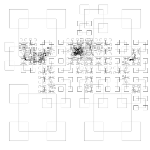
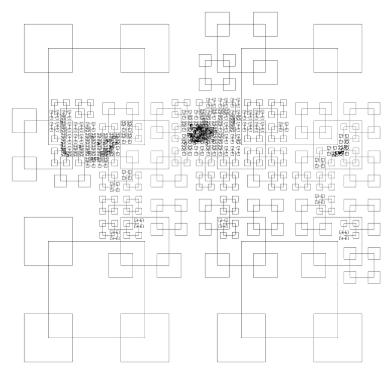
| Description | Map tiles with 32MB of OpenStreetMap data
It turns out that Paris is the only place in the world where you have to go as far as zoom level 11 to get your .pbf-format map tiles to be less than 32MB in size, which means about 3 million nodes per tile. Along the whole southern edge of the world, zoom level 2 is plenty. Each square has its edges inset by a quarter-tile from the edge of the tile it represents. Zoom level 0 not shown. Data from planet.osm, March 7, 2013. |
|---|---|
| Author | Eric Fischer |
| Source | http://www.flickr.com/photos/walkingsf/8568201112/in/photostream |
| Date | 2013-03-18 |
| Permission | CC-BY 2.0 |
| Other versions | 
|
This is a Featured image, which means that it has been identified as one of the best examples of OpenStreetMap mapping, or that it provides a useful illustration of the OpenStreetMap project. If you know another image of similar quality, you can nominate it on Featured image proposals.
Front-page image for week 13 of 2013 (25–31 Mar.).
- Image descriptions
- Deutsch : Diese kuriose Karte der Welt zeigt das Ergebnis der Teilung des OpenStreetMap Datensatzes in Vierteln, bis jede dieser vector tiles kleiner als 32MB ist. Ein Experiment von Eric Fischer (Details)
- English : This curious map of the world, shows the result of dividing the OpenStreetMap dataset into quarters until each of these vector tiles is less than 32MB in size. An experiment by Eric Fischer (details)
- français : Cette carte curieuse du monde affiche le résultat de la diction des ensembles de données d'OpenStreetMap en quarts, jusqu'à ce que ces tuiles vectorielles aient une taille inférieure à 32 Mo. Une expérimentation par Eric Fischer détails).
- italiano : Questa curiosa mappa del mondo mostra il risultato della suddivisione del dataset di OpenStreetMap in quarti finché ciascuna vector tile ha una dimensione minore di 32MB. Un esperimento di Eric Fischer (dettagli in inglese)
- 中文(简体) : 相当奇特的世界地图,显示将开放街图资料集切成一块一块大小小于 32MB 的区块。这个实验由 Eric Fischer 執行(详细内容)
- 中文(繁體) : 相當奇特的世界地圖,顯示將開放街圖資料集切成一塊一塊大小小於 32MB 的區塊。這個實驗由 Eric Fischer 执行 (詳細內容)
File history
Click on a date/time to view the file as it appeared at that time.
| Date/Time | Thumbnail | Dimensions | User | Comment | |
|---|---|---|---|---|---|
| current | 01:46, 25 March 2013 | | 2,048 × 2,048 (29 KB) | Harry Wood (talk | contribs) | http://www.flickr.com/photos/walkingsf/8568201112/in/photostream by Eric Fischer - CC Attribution 2.0 |
You cannot overwrite this file.
File usage
The following 7 pages use this file: