File:Data tiles with 32MB of OpenStreetMap data overlaid on MapQuest zoom level 2.png
Jump to navigation
Jump to search


Size of this preview: 600 × 600 pixels. Other resolutions: 240 × 240 pixels | 480 × 480 pixels | 768 × 768 pixels | 1,024 × 1,024 pixels.
Original file (1,024 × 1,024 pixels, file size: 912 KB, MIME type: image/png)
Information
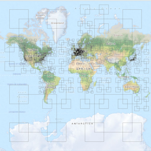
| Description | Map tiles with 32MB of OpenStreetMap data
It turns out that Paris is the only place in the world where you have to go as far as zoom level 11 to get your .pbf-format map tiles to be less than 32MB in size, which means about 3 million nodes per tile. Along the whole southern edge of the world, zoom level 2 is plenty. Each square has its edges inset by a quarter-tile from the edge of the tile it represents. Zoom level 0 not shown. Data from planet.osm, March 7, 2013. Background map taken from MapQuest Open zoom level 2. |
|---|---|
| Author | Data graph by Eric Fischer, Map by MapQuest |
| Source | http://www.flickr.com/photos/walkingsf/8568201112/in/photostream |
| Date | 2013-04-03 |
| Permission | CC-BY-SA 2.0 |
| Other versions | 
|
Licensing
![]()
![]()
![]()
This work is licensed under the Creative Commons Attribution-ShareAlike 2.0 License.
Attribution: Erica Fischer for pattern overlay
Attribution: Erica Fischer for pattern overlay
File history
Click on a date/time to view the file as it appeared at that time.
| Date/Time | Thumbnail | Dimensions | User | Comment | |
|---|---|---|---|---|---|
| current | 22:44, 2 April 2013 | | 1,024 × 1,024 (912 KB) | Seav (talk | contribs) | ==Information== {{Information |Description = '''Map tiles with 32MB of OpenStreetMap data''' It turns out that Paris is the only place in the world where you have to go as far as zoom level 11 to get your .pbf-format map tiles to be less than 32M... |
You cannot overwrite this file.
File usage
The following page uses this file: