File:Dk bing coverage nov 2010.gif
Jump to navigation
Jump to search


Size of this preview: 508 × 600 pixels. Other resolutions: 203 × 240 pixels | 406 × 480 pixels | 972 × 1,148 pixels.
Original file (972 × 1,148 pixels, file size: 203 KB, MIME type: image/gif)
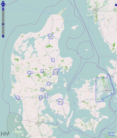
Map with Bing orthophoto coverage for Denmark, based on OSM display of relation #1284621, created by OSM users User:Rasher and User:Findvej, november 2010. Bornholm (outside of visible map) is not covered at all.
Purely based on OSM data, released under CC-BY-SA.
![]()
Contains map data © OpenStreetMap contributors, made available under the terms of the Creative Commons Attribution-ShareAlike 2.0 (CC-BY-SA-2.0).
File history
Click on a date/time to view the file as it appeared at that time.
| Date/Time | Thumbnail | Dimensions | User | Comment | |
|---|---|---|---|---|---|
| current | 18:01, 24 November 2010 | | 972 × 1,148 (203 KB) | Findvej (talk | contribs) | Map with Bing orthophoto coverage for Denmark, based on relation #1284621, created by OSM users User:Rasher and User:Findvej, november 2010. Purely based on OSM data, released under CC-BY-SA. |
You cannot overwrite this file.
File usage
The following page uses this file: