File:EH12QL driving 800.png
Jump to navigation
Jump to search


Size of this preview: 600 × 600 pixels. Other resolutions: 240 × 240 pixels | 480 × 480 pixels.
Original file (800 × 800 pixels, file size: 126 KB, MIME type: image/png)
From http://www.mysociety.org/2007/more-travel-maps/EH12QL_driving_800.png
This is a Featured image, which means that it has been identified as one of the best examples of OpenStreetMap mapping, or that it provides a useful illustration of the OpenStreetMap project. If you know another image of similar quality, you can nominate it on Featured image proposals.
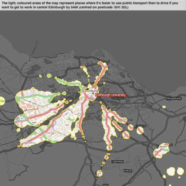
Front-page image for week 13 of 2011 (28 Mar. – 3 Apr.).
- Image descriptions
- Deutsch : Beispiel von mySociety's travel maps, das Startpunkte anzeigt wo ein Verkehrsmittel schneller ist als ein anderes. Hier ist der öffentliche Nahverkehr mit Autos verglichen.
- English : Example of mySociety's travel maps, showing start-locations from which one type of transport beats another (in this case, public-transport vs car)
- français : Exemple d'une carte de mySociety, indiquant le moyen de transport le plus efficace à partir d'un point de départ donné (ici, le transport public est plus rapide que la voiture vers les zones colorées).
- italiano : Esempio di mySociety's travel maps che visualizza i punti di partenza in corrispondenza dei quali si dipartono altri tipi di trasporto (in questo caso il trasporto pubblico e l'automobile)
- lietuvių : mySociety's kelionių žemėlapio pavyzdys rodo vietoves, kuriose tam tikros transporto rūšys yra greitesnės už kitas (šiuo atveju viešas transportas prieš automobilius)
- polski : Przykład z mySociety's travel maps, pokazujący punkty startu, z których jeden środek komunikacji jest szybszy od drugiego. Przykład porównuje środki komunikacji miejskiej z autem.
File history
Click on a date/time to view the file as it appeared at that time.
| Date/Time | Thumbnail | Dimensions | User | Comment | |
|---|---|---|---|---|---|
| current | 19:34, 27 March 2011 | | 800 × 800 (126 KB) | Ojw (talk | contribs) |
You cannot overwrite this file.
File usage
The following 9 pages use this file: