File:FIväistääEpäselvä.png
FIväistääEpäselvä.png (350 × 412 pixels, file size: 146 KB, MIME type: image/png)
Summary
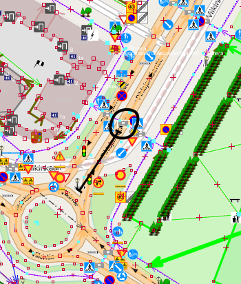
A cycleway crossing a road in Finland between two intersections. It can be argued both ways, that the circled crossing it might or might not be a "part" of the southern roundabout, and cyclists crossing the secondary road there might or might not have to give way to the traffic turning away and northeast from the roundabout. The distance as marked on the picture, is about 31 meters; there's also the bus only carriageway intersecting this, and the distance from the nearest curb corner is only about 7 or 12 meters depending on the side.
(OSM data in JOSM with OSM "standard" layer tiles in the background)
Licensing
![]()
![]()
![]()
Attribution not specified as a parameter! THIS LICENSE ALWAYS REQUIRES ATTRIBUTION! Use {{CC-BY-SA-2.0|Attribution, typically name of author}} See Template:CC-BY-SA-2.0 for full description how this template should be used.
Note, there is
{{CC-BY-SA-2.0 OpenStreetMap}} for files based on old OSM map data, before the license change made on 2012-09-12.There is also
{{OSM Carto screenshot||old_license}} for files based on old OSM map data, before the license change made on 2012-09-12, created using OSM Carto map style.
File history
Click on a date/time to view the file as it appeared at that time.
| Date/Time | Thumbnail | Dimensions | User | Comment | |
|---|---|---|---|---|---|
| current | 17:16, 22 August 2013 | | 350 × 412 (146 KB) | Alv (talk | contribs) | A cycleway crossing a road in Finland between two intersections. It can be argued both ways, that the circled crossing it might or might not be a "part" of the southern roundabout, and cyclists crossing the secondary road there might or might not have ... |
You cannot overwrite this file.
File usage
The following page uses this file: