File:FiGuideCycleDestination.png
Jump to navigation
Jump to search

No higher resolution available.
FiGuideCycleDestination.png (180 × 180 pixels, file size: 9 KB, MIME type: image/png)
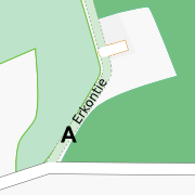
Example of a combined cycleway/footway allowing motorcar access to houses along it.
File history
Click on a date/time to view the file as it appeared at that time.
| Date/Time | Thumbnail | Dimensions | User | Comment | |
|---|---|---|---|---|---|
| current | 07:45, 30 January 2008 | | 180 × 180 (9 KB) | Alv (talk | contribs) | Example of a combined cycleway/footway allowing motorcar access to houses along it. |
You cannot overwrite this file.
File usage
The following 2 pages use this file: