File:Golf course layers.png
Jump to navigation
Jump to search

Size of this preview: 800 × 465 pixels. Other resolutions: 320 × 186 pixels | 809 × 470 pixels.
Original file (809 × 470 pixels, file size: 140 KB, MIME type: image/png)
Summary
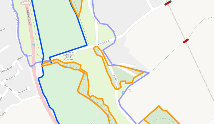
Layer tags used incorrectly with woods on layer 2, a golf course on layer -1 and a common on layer -2. These features are all at ground level and will render correctly without layering.
Licensing
![]()
![]()
![]()
This work is licensed under the Creative Commons Attribution-ShareAlike 2.0 License.
Attribution not specified as a parameter! THIS LICENSE ALWAYS REQUIRES ATTRIBUTION! Use {{CC-BY-SA-2.0|Attribution, typically name of author}} See Template:CC-BY-SA-2.0 for full description how this template should be used.
Note, there is
There is also
Attribution not specified as a parameter! THIS LICENSE ALWAYS REQUIRES ATTRIBUTION! Use {{CC-BY-SA-2.0|Attribution, typically name of author}} See Template:CC-BY-SA-2.0 for full description how this template should be used.
Note, there is
{{CC-BY-SA-2.0 OpenStreetMap}} for files based on old OSM map data, before the license change made on 2012-09-12.There is also
{{OSM Carto screenshot||old_license}} for files based on old OSM map data, before the license change made on 2012-09-12, created using OSM Carto map style.
File history
Click on a date/time to view the file as it appeared at that time.
| Date/Time | Thumbnail | Dimensions | User | Comment | |
|---|---|---|---|---|---|
| current | 22:04, 24 June 2011 | | 809 × 470 (140 KB) | PeterIto (talk | contribs) | [http://www.itoworld.com/product/data/ito_map/main?view=22&lat=51.80084021182912&lon=-0.34501181764892425&zoom=16 Layer tags used incorrectly] with woods on layer 2, a golf course on layer -1 and a common on layer -2. These features are all at ground leve |
You cannot overwrite this file.
File usage
The following 11 pages use this file: