File:Guagua ESSC-OSMPH Training field survey.jpg
Jump to navigation
Jump to search


Size of this preview: 800 × 600 pixels. Other resolutions: 320 × 240 pixels | 640 × 480 pixels | 1,024 × 768 pixels | 1,280 × 960 pixels | 2,560 × 1,920 pixels | 4,000 × 3,000 pixels.
Original file (4,000 × 3,000 pixels, file size: 2.65 MB, MIME type: image/jpeg)
Information
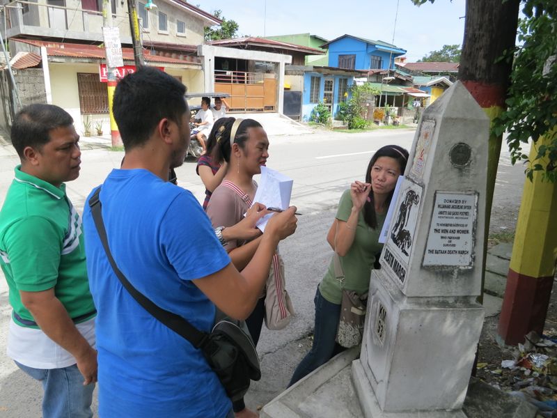
| Description | On day 2 of the ESSC-OSMPH Disaster Risk Reduction Training held last November 5–7, 2013 in Guagua (Pampanga, Philippines) |
|---|---|
| Author | Eugene Alvin Villar (seav) |
| Source | Author's photograph |
| Date | 2013-11-06 |
| Permission |
This work is licensed under the Creative Commons Attribution-ShareAlike 4.0 License.
Attribution: Eugene Alvin Villar
|
This is a Featured image, which means that it has been identified as one of the best examples of OpenStreetMap mapping, or that it provides a useful illustration of the OpenStreetMap project. If you know another image of similar quality, you can nominate it on Featured image proposals.
Front-page image for week 51 of 2013 (16–22 Dec.).
- Image descriptions
- Deutsch : In einem OSM-Training zur Katastrophenrisikoreduktion im November 2013 in Guagua (Pampanga, Philippinen) wurden die Teilnehmer in Gruppen aufgeteilt und führten eine Erkundung/Begehung in vielen Teilen der Stadt durch. Im Foto ist die Betis-Gruppe beim Notieren von Informationen neben einem Geschichtsstein der „Death March“-Route
 „Death March“-Route (Todesmarsch) zu sehen.
 - English : During an disaster risk reduction OSM training held November 2013 in Guagua (Pampanga, Philippines) the participants were divided into groups and did a field survey in various parts of the town. Shown in the photo is the Betis group taking down notes beside a Death March trail historical marker Death March trail historical marker.
- español : En un entrenamiento de OSM para la reducción de riesgo de desastres en Noviembre del 2013 en Guagua (Pampanga, Filipinas) los participantes fueron divididos en grupos y llevaron a cabo una exploración en muchas partes de la ciudad. En la foto el grupo Betis está tomando notas al lado del marcador histórico de la «marcha de la muerte» marcador histórico de la «marcha de la muerte».
- français : Pendant un entrainement OpenStreetMap pour la réduction des risques en cas de catastrophe tenue en novembre 2013 à Guagua (Pampanga, Philippines), les participants étaient divisés en plusieurs groupes et ont effectué une reconnaissance sur le terrain dans plusieurs quartiers de la ville. La photo montre le groupe s'occupant de Betis qui prend des notes face à un mémorial de la Marche de la Mort mémorial de la Marche de la Mort.
- italiano : Nel corso di un'attività di OSM per la riduzione del rischio nei disastri che si è tenuta a novembre 2013 a Guagua (Pampanga, Filippine) i partecipanti sono stati divisi in gruppi e hanno fatto rilevazioni sul campo in varie parti della città. Nella foto si vede il gruppo Betis che prende appunti davanti a un punto di riferimento storico del percorso della Death March punto di riferimento storico del percorso della Death March
- русский : В ноябре 2013 года в филиппинском муниципалитете Гуагуа в рамках программы по уменьшению рисков от стихийных бедствий прошла тренировка новичков ОСМ. Участники разделились на группы, обошли разные части города и собрали новые данные для карты. На фото волонтёры делают заметки у мемориала в память о марше Смерте. у мемориала в память о марше Смерте.
- 中文(简体) : 2013年11月在Guagua (Pampanga, Philippines)举行的减少灾害风险开放街图训练课程中,参与者分组采用实地踏查方式去了城镇中不少地方。这张图片显示在Betis一带,一群人在死亡行军路径的历史标志 死亡行军路径的历史标志写下笔记。
- 中文(繁體) : 2013年11月在Guagua (Pampanga, Philippines)舉行的減少災害風險開放街圖訓練課程中,參與者分組採用實地踏查方式去了城鎮中不少地方。這張圖片顯示在Betis一帶,一群人在死亡行軍路徑的歷史標誌 死亡行軍路徑的歷史標誌寫下筆記。
File history
Click on a date/time to view the file as it appeared at that time.
| Date/Time | Thumbnail | Dimensions | User | Comment | |
|---|---|---|---|---|---|
| current | 04:24, 23 January 2019 | | 4,000 × 3,000 (2.65 MB) | Seav (talk | contribs) | Upload full resolution photo. |
| 22:59, 9 December 2013 |  | 960 × 720 (93 KB) | Seav (talk | contribs) | ==Information== {{Information |Description = The Betis group of participants from the Guagua ESSC-OSMPH Training had a field survey on Day 2. Here they are taking down notes beside a Death March Monument in Barangay San Nicolas 2nd. |Source ... |
You cannot overwrite this file.
File usage
The following file is a duplicate of this file (more details):
- File:Guagua ESSC-OSMPH Training field survey.jpg from Wikimedia Commons
The following 10 pages use this file: