File:Heatmap-municipios-sem-mapeamento BR.png
Jump to navigation
Jump to search


Size of this preview: 800 × 439 pixels. Other resolutions: 320 × 176 pixels | 640 × 351 pixels | 1,038 × 570 pixels.
Original file (1,038 × 570 pixels, file size: 126 KB, MIME type: image/png)
Summary
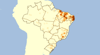
Mapa de calor que mostra os municípios ainda sem vias residenciais no território Brasileiro, para determinar vetores de mapeamento da comunidade.
This is a Featured image, which means that it has been identified as one of the best examples of OpenStreetMap mapping, or that it provides a useful illustration of the OpenStreetMap project. If you know another image of similar quality, you can nominate it on Featured image proposals.
Front-page image for week 28 of 2016 (11–17 Jul.).
- Image descriptions
- English : Luc Freitas analysed mapping progress of Brazilian cities (diary entry in Portuguese). He looked at the size of cities based on municipal boundaries data (already imported from IBGE), and correlated this with the amount of residential roads data in OpenStreetMap. This image and the tabular output helps guide further mapping efforts by the Brazilian community.
- italiano : Luc Freitas ha analizzato il progresso della mappatura delle città Brasiliane (la voce del diario è in portoghese). Ha guardato alla dimensione delle città sulla base dei dati dei confini municipali (già importati da IBGE) e l'ha correlata con la quantità di strade residenziali in OpenStreetMap. Questa immagine e la tabella aiutano a guidare gli ulteriori sforzi di mappatura da parte della comunità brasiliana.
- русский : Люк Фрейтас проанализировал процесс картирования Бразилии и поделился результатами у себя в блоге. Он импортировал границы городов из реестра Бразильского института географии и статистики, а потом сопоставил размеры территорий с количеством дорог внутри жилых зон по версии ОСМ. Полученные визуализация и таблица помогут бразильскому сообществу скоординировать дальнейшую работу.
- 中文(简体) : Luc Freitas 分析巴西城市绘图的进度(葡萄牙文记途的日记项目)。他从城市的行政边界大小(从IBGE汇入),来看开放街图相对应的住宅道路数量。这张图片和汇出表格协助巴西社群引导他们的绘图行动。
- 中文(繁體) : Luc Freitas 分析巴西城市繪圖的進度(葡萄牙文記途的日記項目)。他從城市的行政邊界大小(從IBGE匯入),來看開放街圖相對應的住宅道路數量。這張圖片和匯出表格協助巴西社群引導他們的繪圖行動。
Licensing
| Contains map data © OpenStreetMap contributors, made available under the terms of the Open Database License (ODbL).
The ODbL does not require any particular license for maps produced from ODbL data, produced maps may be subject also to other licences. |
File history
Click on a date/time to view the file as it appeared at that time.
| Date/Time | Thumbnail | Dimensions | User | Comment | |
|---|---|---|---|---|---|
| current | 05:08, 19 April 2016 | | 1,038 × 570 (126 KB) | LucFreitas (talk | contribs) | Mapa de calor que mostra os municípios sem vias residenciais no território Brasileiro. |
You cannot overwrite this file.
File usage
The following 10 pages use this file:
- Cidades brasileiras com mapeamento deficitário
- Featured images/Jul-Sep 2016
- List of featured images/2016
- Zh-hans:Featured images/Jul-Sep 2016
- Template:Featured image d3
- Template:Iotw image/2016-28
- DE:Featured images/Jul-Sep 2016
- FR:Featured images/Jul-Sep 2016
- ES:Featured images/Jul-Sep 2016
- IT:Featured images/Jul-Sep 2016