File:Howcongestedismyroad.org.uk.png
Jump to navigation
Jump to search


No higher resolution available.
Howcongestedismyroad.org.uk.png (600 × 354 pixels, file size: 472 KB, MIME type: image/png)
Summary
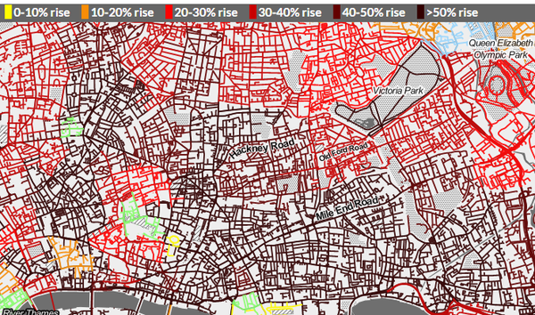
Traffic map from transport campaigning website http://www.howcongestedismyroad.org.uk
Image released here CC BY SA with permission
This is a Featured image, which means that it has been identified as one of the best examples of OpenStreetMap mapping, or that it provides a useful illustration of the OpenStreetMap project. If you know another image of similar quality, you can nominate it on Featured image proposals.
Front-page image for week 38 of 2015 (14–20 Sep.).
- Image descriptions
- asturianu : La web de campaña de tresporte howcongestedismyroad.org.uk (Cómo d'atascada ta la mio ruta, Reinu Xuníu) amuesa datos modelaos de tráficu de los tresportes de Londres, en correllación colos datos de les redes de rutes d'OpenStreetMap y superpuestos cola presentación cartográfica d'estilu toner prietu y blancu de Stamen.
- English : Transport campaigning website howcongestedismyroad.org.uk shows traffic modelling data from Transport For London, snapped onto OpenStreetMap road network data and overlaid over Stamen's black & white toner style base-map
- français : Le site web de campagne de transport howcongestedismyroad.org.uk (Comment ma route est-elle congestionnée, Royaume-Uni) affiche des données modelées de traffic des transports dans Londres, en corrélation avec les données des réseaux routiers d'OpenStreetMap. La présentation cartographique de type toner noir & blanc de Stamen est utilisée.
- italiano : Il sito web per la campagna sul trasporto howcongestedismyroad.org.uk mostra i dati del modello del traffico di Transport For London agganciati alla rete stradale di OpenStreetMap e sovrapposti alla mappa di base in bianco e nero "toner" di Stamen.
- русский : На сайте howcongestedismyroad.org.uk появилась карта, которая показывает результаты моделирования интенсивности движения в Лондоне. Данные накинты на дорожню сеть ОСМ, а для фонового слоя использован стиль Стамен.
- 中文(简体) : 大众运输倡议网站howcongestedismyroad.org.uk 显示伦敦的交通流量模拟资料,嵌入开放街图的道路网资料,与Stamen 黑白蜡笔风格底图地图。
- 中文(繁體) : 大眾運輸倡議網站 howcongestedismyroad.org.uk 顯示倫敦的交通流量模擬資料,嵌入開放街圖的道路網資料,與 Stamen 黑白蠟筆風格底圖地圖。
Licensing
![]()
![]()
![]()
This work is licensed under the Creative Commons Attribution-ShareAlike 3.0 License.
Attribution not specified as a parameter! THIS LICENSE ALWAYS REQUIRES ATTRIBUTION! Use {{CC-BY-SA-3.0|Attribution, typically name of author}} See Template:CC-BY-SA-3.0 for full description how this template should be used.
Attribution not specified as a parameter! THIS LICENSE ALWAYS REQUIRES ATTRIBUTION! Use {{CC-BY-SA-3.0|Attribution, typically name of author}} See Template:CC-BY-SA-3.0 for full description how this template should be used.
File history
Click on a date/time to view the file as it appeared at that time.
| Date/Time | Thumbnail | Dimensions | User | Comment | |
|---|---|---|---|---|---|
| current | 10:37, 15 September 2015 | | 600 × 354 (472 KB) | Harry Wood (talk | contribs) | Traffic map from transport campaigning website http://www.howcongestedismyroad.org.uk Image released here CC BY SA [https://twitter.com/tom_chance/status/643734463214653440 with permission] |
You cannot overwrite this file.