File:Humanitarian mapping project editing activity timelines.png
Jump to navigation
Jump to search


Size of this preview: 800 × 473 pixels. Other resolutions: 320 × 189 pixels | 640 × 378 pixels | 1,024 × 605 pixels | 1,280 × 757 pixels | 1,849 × 1,093 pixels.
Original file (1,849 × 1,093 pixels, file size: 508 KB, MIME type: image/png)
Summary
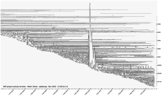
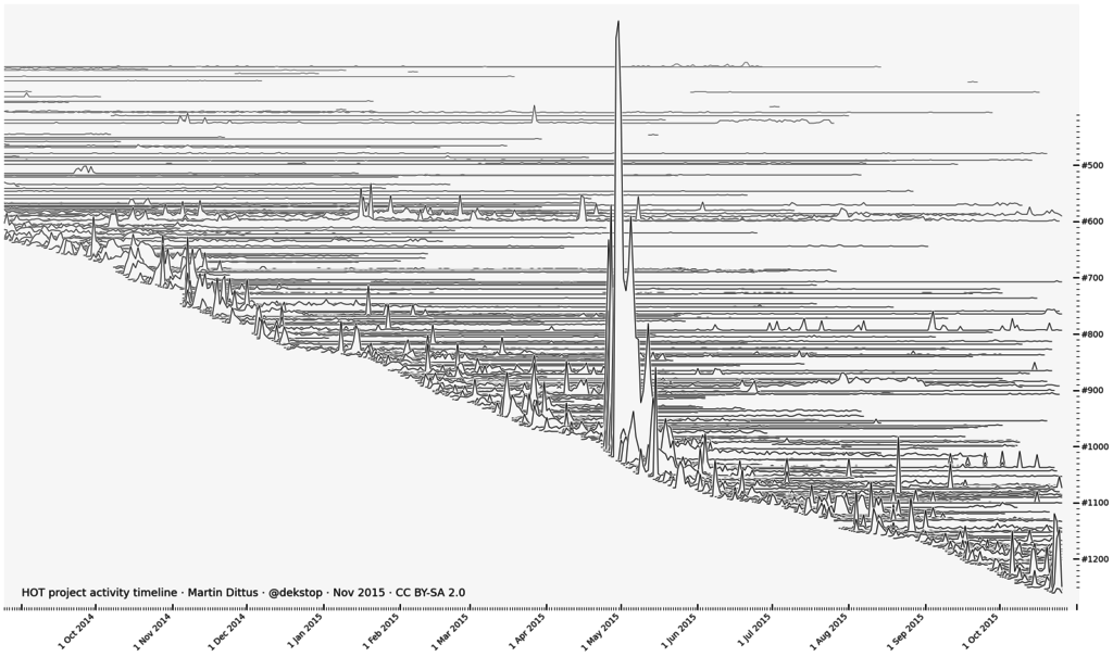
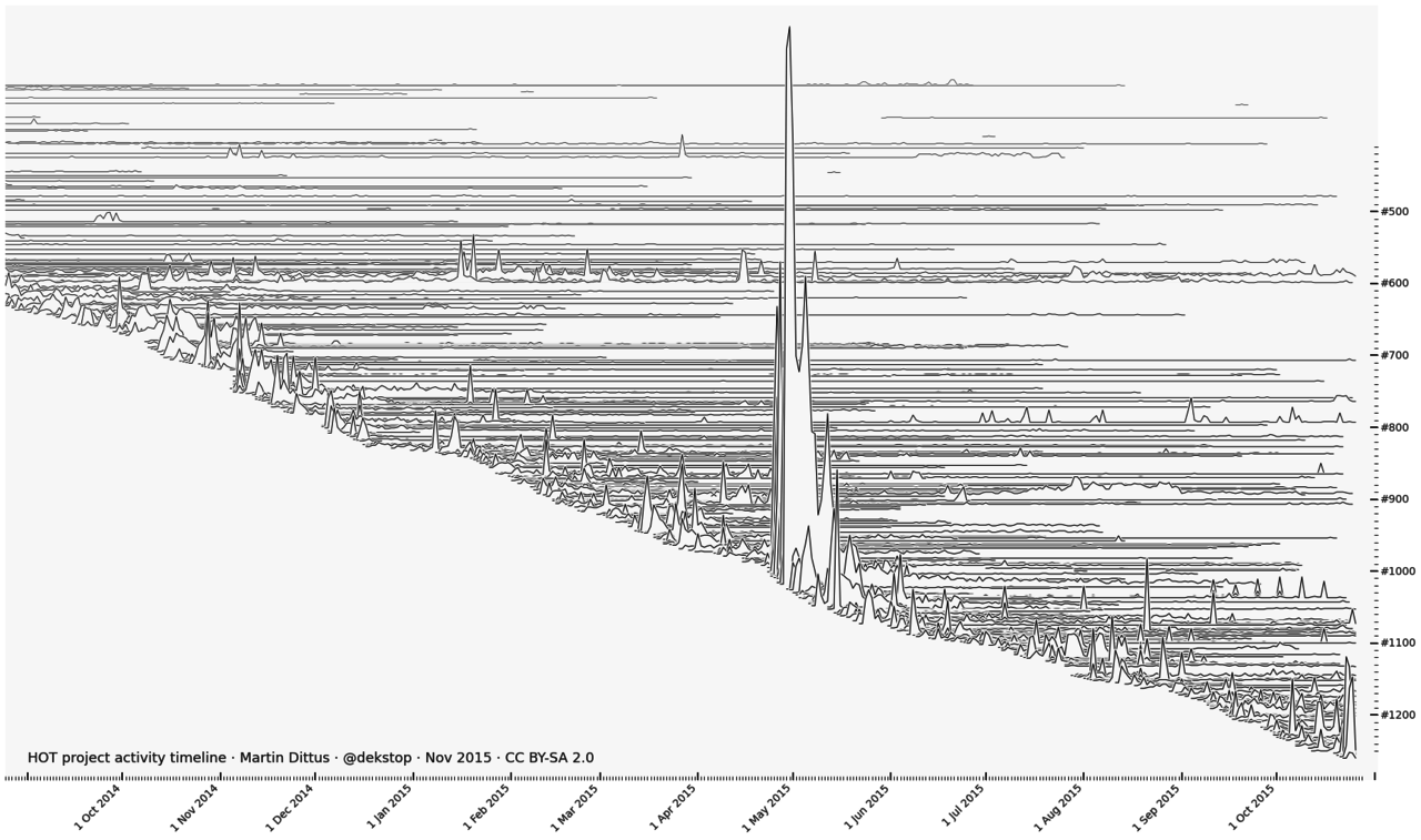
One of many visualisations by Martin Dittus from his slides full of stats & charts about humanitarian mapping projects. This shows tasks.hotosm.org projects by HOT and the recent Missing Maps Project, each with their own horizontal timeline, kicking off one after the other. Spikes of editing activity include the spectacular 2015 Nepal earthquake response. Read more here
This is a Featured image, which means that it has been identified as one of the best examples of OpenStreetMap mapping, or that it provides a useful illustration of the OpenStreetMap project. If you know another image of similar quality, you can nominate it on Featured image proposals.
Front-page image for week 47 of 2015 (16–22 Nov.).
- Image descriptions
- Bahasa Indonesia : Salah satu dari banyak visualisasi berdasarkan Martin Dittus dari nya slide penuh statistik & grafik tentang proyek pemetaan kemanusiaan. Menunjukkan ini tasks.hotosm.org proyek berdasarkan HOT dan baru-baru ini Missing Maps Project, masing-masing dengan waktu horisontal mereka sendiri, menendang satu demi satu. Paku aktivitas editing termasuk 2015 Nepal gempa respon spektakuler. Baca lebih lanjut di sini
- English : One of many visualisations by Martin Dittus from his slides full of stats & charts about humanitarian mapping projects. This shows tasks.hotosm.org projects by HOT and the recent Missing Maps Project, each with their own horizontal timeline, kicking off one after the other. Spikes of editing activity include the spectacular 2015 Nepal earthquake response. Read more here
- italiano : Una delle molte visualizzazioni di Martin Dittus tratta dalle sue slide piene di statistiche e grafici sui progetti di mappatura umanitaria. Questa mostra i progetti tasks.hotosm.org di HOT e il recente Missing Maps Project, ognuno con la propria timeline orizzontale, che partono uno dopo l'altro. I picchi di attività includono la spettacolare risposta «2015 Nepal earthquake». Maggiori informazioni in inglese qui.
- русский : Эту визуализацию сделал Мартин Диттус, она взята из его презентации про гуманитарные проекты ОСМа (на слайдах полно диаграмм и статистики). График изображает проекты на tasks.hotosm.org: это работа волонтёров из Missing Maps Project и HOT. Самый высокий скачок соответствуют землетрясению в Непале в апреле 2015 года. Детали визуализации описаны Мартином в блоге.
- 中文(简体) : 由Martin Dittus 制作的众多视觉化呈现作品之一-人道画地图专案的统计数据和图表简报页面,显示由 HOT 领导的 tasks.hotosm.org,以及最近的 Missing Maps Project 状况,各自有自己的水平时间轴,一个接着一个。编辑活动尖峰包括回响相当大的2015尼泊尔地震。了解更多资讯
- 中文(繁體) : 由 Martin Dittus 製作的眾多視覺化呈現作品之一-人道畫地圖專案的統計數據和圖表簡報頁面,顯示由 HOT 領導的 tasks.hotosm.org,以及最近的 Missing Maps Project 狀況,各自有自己的水平時間軸,一個接著一個。編輯活動尖峰包括回響相當大的 2015尼泊爾地震。瞭解更多資訊
Licensing
![]()
![]()
![]()
This work is licensed under the Creative Commons Attribution-ShareAlike 2.0 License.
Attribution not specified as a parameter! THIS LICENSE ALWAYS REQUIRES ATTRIBUTION! Use {{CC-BY-SA-2.0|Attribution, typically name of author}} See Template:CC-BY-SA-2.0 for full description how this template should be used.
Note, there is
There is also
Attribution not specified as a parameter! THIS LICENSE ALWAYS REQUIRES ATTRIBUTION! Use {{CC-BY-SA-2.0|Attribution, typically name of author}} See Template:CC-BY-SA-2.0 for full description how this template should be used.
Note, there is
{{CC-BY-SA-2.0 OpenStreetMap}} for files based on old OSM map data, before the license change made on 2012-09-12.There is also
{{OSM Carto screenshot||old_license}} for files based on old OSM map data, before the license change made on 2012-09-12, created using OSM Carto map style.
Martin Dittus. (Permission [1])
File history
Click on a date/time to view the file as it appeared at that time.
| Date/Time | Thumbnail | Dimensions | User | Comment | |
|---|---|---|---|---|---|
| current | 13:05, 6 November 2015 | | 1,849 × 1,093 (508 KB) | Harry Wood (talk | contribs) | new version by Martin, bringing the timeline more up-to-date [https://www.openstreetmap.org/user/dekstop/diary/36253] |
| 00:32, 1 November 2015 | 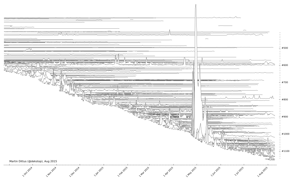 | 954 × 594 (145 KB) | Harry Wood (talk | contribs) | One of several visualisations of humanitarian mapping projects created by Martin Dittus |
You cannot overwrite this file.
File usage
The following 6 pages use this file: