File:I-55 and I-90.png
Jump to navigation
Jump to search


Size of this preview: 607 × 600 pixels. Other resolutions: 243 × 240 pixels | 486 × 480 pixels | 765 × 756 pixels.
Original file (765 × 756 pixels, file size: 160 KB, MIME type: image/png)
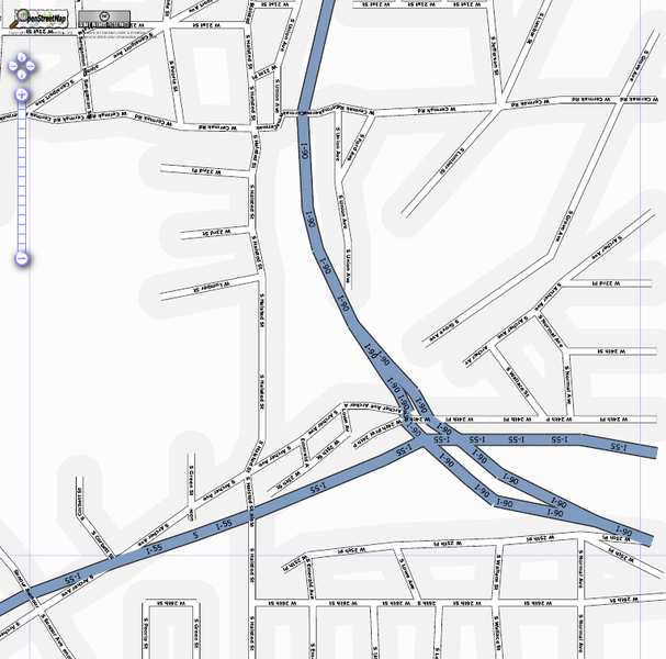
Map of Chicago
This map and others like it, were created by OpenStreetmap contributors, and are licensed as Creative Commons CC-BY-SA 2.0 (https://creativecommons.org/licenses/by-sa/2.0/) (see OpenStreetMap licence).
Use {{mapof|PlaceName}} to add this template to your images.
This map and others like it, were created by OpenStreetmap contributors, and are licensed as Creative Commons CC-BY-SA 2.0 (https://creativecommons.org/licenses/by-sa/2.0/) (see OpenStreetMap licence).
Use {{mapof|PlaceName}} to add this template to your images.
An 2006 image of the Interstate 55/Interstate 90 junction in Chicago. Enlarged from SVG file centred on Chicago in seach box.
This file was originally uploaded by User:Steve8 at File:Chicago.png, however that name has been overtaken by a newer, broader image of Chicago.
This is a Featured image, which means that it has been identified as one of the best examples of OpenStreetMap mapping, or that it provides a useful illustration of the OpenStreetMap project. If you know another image of similar quality, you can nominate it on Featured image proposals.
Front-page image on 28 Oct 2006
File history
Click on a date/time to view the file as it appeared at that time.
| Date/Time | Thumbnail | Dimensions | User | Comment | |
|---|---|---|---|---|---|
| current | 00:34, 15 December 2011 | | 765 × 756 (160 KB) | Mrwojo (talk | contribs) | {{mapof|Chicago}} Chicago - enlarged from SVG file centred on Chicago in seach box {{featured|reason=show quality of imported TIGER data}} |
You cannot overwrite this file.
File usage
The following 4 pages use this file: