File:ITO Map - Layers.png
Jump to navigation
Jump to search


Size of this preview: 799 × 182 pixels. Other resolutions: 320 × 73 pixels | 1,141 × 260 pixels.
Original file (1,141 × 260 pixels, file size: 219 KB, MIME type: image/png)
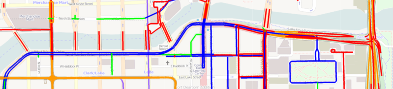
The ITO Map Layers view showing features tagged as red (level 1) and orange (levels 2/3/4) and as blue (level -1) and light blue (levels -1/-2/-3). Level 0 is shown as green.
File history
Click on a date/time to view the file as it appeared at that time.
| Date/Time | Thumbnail | Dimensions | User | Comment | |
|---|---|---|---|---|---|
| current | 21:05, 3 March 2011 | 1,141 × 260 (219 KB) | PeterIto (talk | contribs) | The ITO Map Layers view showing features tagged as red (level 1) and orange (levels 2/3/4) and as blue (level -1) and light blue (levels -1/-2/-3). Level 0 is shown as green. |
You cannot overwrite this file.
File usage
The following 3 pages use this file: