File:Inception maps.png
Jump to navigation
Jump to search


No higher resolution available.
Inception_maps.png (519 × 473 pixels, file size: 350 KB, MIME type: image/png)
Summary
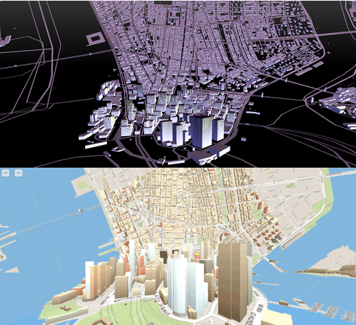
screenshot of Tangram bendy map and of OSMbuildings inception map
http://googlemapsmania.blogspot.co.uk/2015/10/inception-mapping.html
This is a Featured image, which means that it has been identified as one of the best examples of OpenStreetMap mapping, or that it provides a useful illustration of the OpenStreetMap project. If you know another image of similar quality, you can nominate it on Featured image proposals.
Front-page image for week 44 of 2015 (26 Oct. – 1 Nov.).
- Image descriptions
- Bahasa Indonesia : Mengambil peta datar di bagian atas, dan membungkuk untuk membentuk peta 3D permukaan jalan di bagian bawah tampilan. Efek ini mirip dengan cityscapes melengkung mengganggu dalam film 'Inception'. Berikut adalah dua implementasi berjalan di browser menggunakan ubin OpenStreetMap data vektor dengan Tangram dan dengan OSMBuildings. Baca lebih lanjut pada blog googlemapsmania.
- Bahasa Melayu : Kesan seperti lengkungan wajah kota dalam filem Inception dengan mempamerkan peta datar di bahagian atas dan melentokkannya dengan peta 3D di bahagian bawah tampilan. Ada dua implementasi yang boleh dipertontonkan dalam pelayar dengan data vektor jubin OpenStreetMap menggunakan sama ada Tangram atau OSMBuildings. Bacaan lanjut dalam blog Maps Mania.
- English : Taking a flat map at the top, and bending it to form a street level 3D map at the bottom of the view. This effect is similar to the disturbing warped cityscapes in the movie 'Inception'. Here are two implementations running in the browser using tiled OpenStreetMap vector data with Tangram and with OSMBuildings. Read more on the googlemapsmania blog.
- italiano : Partendo dalla mappa piatta in alto e piegandola fino a formare una mappa 3D a livello stradale in basso, l'effetto è simile agli inquietanti panorami urbani distorti del film «Inception». Qui ci sono due implementazioni in esecuzione nel browser usando tile di dati vettoriali di OpenStreetMap con Tangram e con OSMBuildings. Maggiori informazioni (in inglese) sul blog googlemapsmania.
- русский : Эти две согнутые трёхмерные карты напоминают сцену из фильма «Начало». Обе используют векторыне тайлы данных ОСМ и работают в браузере (см. Tangram и OSMBuildings). Подробности в блоге.
- 中文(简体) : 将地图平放在上面,然后弯曲让从下面观看时形成街道路网层级的3D 地图。这样的效果类似弯曲的城市景观,像是类似电影'盗梦空间'的景观。这边有两个利用开放街图向量资料的实作例子,Tangram 和OSMBuildings。请看on the googlemapsmania 部落格文章了解更多细节。
- 中文(繁體) : 將地圖平放在上面,然後彎曲讓從下面觀看時形成街道路網層級的 3D 地圖。這樣的效果類似彎曲的城市景觀,像是類似電影'全面啟動'的景觀。這邊有兩個利用開放街圖向量資料的實作例子,Tangram 和 OSMBuildings。請看 on the googlemapsmania 部落格文章瞭解更多細節。
Licensing
Both Mapzen and OSMBuildings have given permissions for screenshots of their stuff to be used for image of the week and released with an open license. OSMBuildings also features (in a minor way) tiles from Mapbox
Mashed together by harry CC-BY-SA.20
File history
Click on a date/time to view the file as it appeared at that time.
| Date/Time | Thumbnail | Dimensions | User | Comment | |
|---|---|---|---|---|---|
| current | 11:49, 26 October 2015 | | 519 × 473 (350 KB) | Harry Wood (talk | contribs) | screenshot of [http://meetar.github.io/bendy-map/#14/40.7222/-73.9981 Tangram bendy map] and of [http://osmbuildings.org/examples/inception/?lat=40.69993&lon=-74.01636&zoom=17.0&tilt=90.0&rotation=30.0 OSMbuildings inception map] http://googlemapsmani... |
You cannot overwrite this file.
File usage
The following 6 pages use this file: