File:LandkreisMuenchenGemeinden.png
Jump to navigation
Jump to search

Size of this preview: 536 × 599 pixels. Other resolutions: 215 × 240 pixels | 429 × 480 pixels | 928 × 1,037 pixels.
Original file (928 × 1,037 pixels, file size: 935 KB, MIME type: image/png)
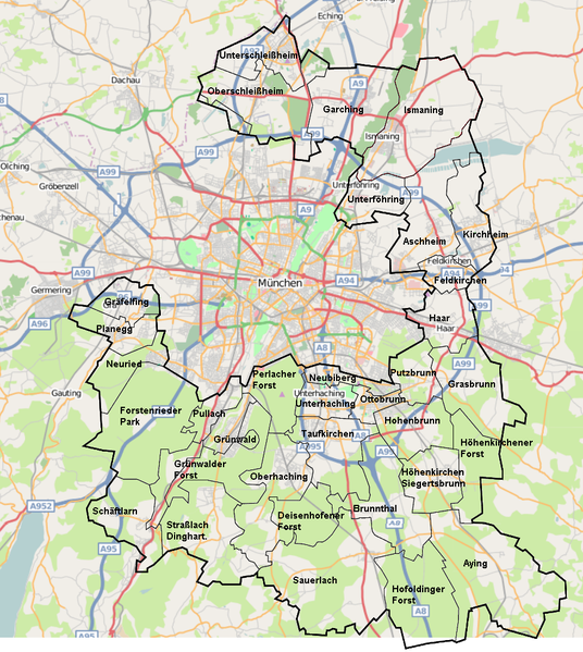
Map of the 'Gemeinden' of the Landkreis München. Created from a screenshot of OSM and the file Ismaninglkrm.svg from Manuel Schunder (see http://de.wikipedia.org/wiki/Bild:Ismaninglkrm.svg, licensed under Creative Commons Attribution ShareAlike 3.0 Unported)
![]()
This media file does not have sufficient information on its copyright status. If you have created this file yourself, or the file is available under some open licence allowing its use on OSM Wiki or the file is in the public domain, you can edit the file description page to license it under one of the allowed licences. If you did not create it and it is not in the public domain, you must ask the copyright holder for permission to release it under one of the allowed licenses. Wiki:Media file license chart may be helpful to find a suitable licence.
Files without licences marked with this template are listed in Category:Media without a license or one of its subcategories. If the file is without a known open licence: ask its uploader to clarify situation or find a replacement and mark this file with {{Superseded by Commons}} and replace its uses.
Files without licences marked with this template are listed in Category:Media without a license or one of its subcategories. If the file is without a known open licence: ask its uploader to clarify situation or find a replacement and mark this file with {{Superseded by Commons}} and replace its uses.
If uploader was notified this month: use {{No licence|subcategory=uploader notified 2024, April}} - to put media into Category:Media without a license - uploader notified 2024, April and mark image as one where uploader was notified.
File history
Click on a date/time to view the file as it appeared at that time.
| Date/Time | Thumbnail | Dimensions | User | Comment | |
|---|---|---|---|---|---|
| current | 13:26, 14 December 2007 | | 928 × 1,037 (935 KB) | Grungelborz (talk | contribs) | Map of the 'Gemeinden' of the Landkreis München. Created from a screenshot of OSM and the file Ismaninglkrm.svg from Manuel Schunder (see http://de.wikipedia.org/wiki/Bild:Ismaninglkrm.svg, licensed under Creative Commons Attribution ShareAlike 3.0 Unpo |
You cannot overwrite this file.
File usage
There are no pages that use this file.