File:Lanes ex example1.png
Jump to navigation
Jump to search


No higher resolution available.
Lanes_ex_example1.png (547 × 487 pixels, file size: 353 KB, MIME type: image/png)
Summary
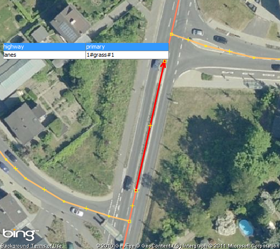
First example for proposed feature lanes_ex.
Licensing
![]()
![]()
![]()
This work is licensed under the Creative Commons Attribution-ShareAlike 2.0 License.
Attribution not specified as a parameter! THIS LICENSE ALWAYS REQUIRES ATTRIBUTION! Use {{CC-BY-SA-2.0|Attribution, typically name of author}} See Template:CC-BY-SA-2.0 for full description how this template should be used.
Note, there is
There is also
Attribution not specified as a parameter! THIS LICENSE ALWAYS REQUIRES ATTRIBUTION! Use {{CC-BY-SA-2.0|Attribution, typically name of author}} See Template:CC-BY-SA-2.0 for full description how this template should be used.
Note, there is
{{CC-BY-SA-2.0 OpenStreetMap}} for files based on old OSM map data, before the license change made on 2012-09-12.There is also
{{OSM Carto screenshot||old_license}} for files based on old OSM map data, before the license change made on 2012-09-12, created using OSM Carto map style.
![]()
![]()
This image is composed entirely, or almost entirely, of Bing aerial imagery.
Bing imagery is not open licensed, but is generously made available to the OpenStreetMap project for deriving open licensed map data in editors such as JOSM, iD or Vespucci. This upload is not covered by permission described at Bing Maps, as OSM Wiki cannot be interpreted as "editor application" and "We require you use access credentials to use the service and require use of transaction tracking and/or session tracking methods for all uses of the service" is not fulfilled.
This image is a relatively minor extract of the (worldwide) Bing imagery, used for illustrative purposes on the OpenStreetMap wiki, to help document ways of using and interpreting the imagery in the OpenStreetMap mapping process.
This image is a relatively minor extract of the (worldwide) Bing imagery, used for illustrative purposes on the OpenStreetMap wiki, to help document ways of using and interpreting the imagery in the OpenStreetMap mapping process.
File history
Click on a date/time to view the file as it appeared at that time.
| Date/Time | Thumbnail | Dimensions | User | Comment | |
|---|---|---|---|---|---|
| current | 21:31, 24 June 2011 | | 547 × 487 (353 KB) | Bürste (talk | contribs) | First example for proposed feature lanes_ex. |
You cannot overwrite this file.
File usage
The following 2 pages use this file: