File:Lauri Vanhala Helsinki map.jpg
Jump to navigation
Jump to search


Size of this preview: 800 × 399 pixels. Other resolutions: 320 × 160 pixels | 640 × 320 pixels | 1,280 × 639 pixels.
Original file (1,280 × 639 pixels, file size: 255 KB, MIME type: image/jpeg)
Summary
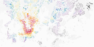
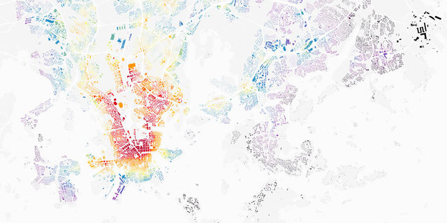
"Figuring out the best place to live in Helsinki": http://www.wanhala.net/post/156484186523/figuring-out-the-best-place-to-live-in-helsinki
Lauri Vanhala took OpenStreetMap buildings in Helsinki, analysed the location of jobs and travel times from every building, and produced this map to help decide the best place to live.
This is a Featured image, which means that it has been identified as one of the best examples of OpenStreetMap mapping, or that it provides a useful illustration of the OpenStreetMap project. If you know another image of similar quality, you can nominate it on Featured image proposals.
Front-page image for week 9 of 2017 (27 Feb. – 5 Mar.).
- Image descriptions
- Deutsch : Lauri Vanhala produzierte mithilfe der Gebäudedaten in OpenStreetMap eine Karte, um herauszufinden, wo man in Helsinki am besten leben kann. Dazu analysierte er die Fahrzeiten zum Arbeitsort von jedem Gebäude aus. Sieh die Karte an and lies mehr darüber in diesem Blogpost.
- English : Lauri Vanhala took OpenStreetMap buildings in Helsinki, analysed the location of jobs and travel times from every building, and produced this map to help decide the best place to live. Browse the full map and read more on this blog.
- français : Lauri Vanhala a extrait les bâtiments d'Helsinki présents dans OpenStreetMap, a analysé l'emplacement des emplois et temps de trajets depuis chaque bâtiment et produit cette carte pour aider à décider les meilleurs lieux de résidence. Consulter la carte complète et en savoir plus sur son blogue.
- italiano : Lauri Vanhala ha preso gli edifici di OpenStreetMap a Helsinki, ha analizzato la posizione dei luoghi di lavoro e dei tempi di viaggio da ogni edificio e ha prodotto questa mappa che aiuta a decidere il miglior luogo dove vivere. Naviga nella mappa completa e leggi ulteriori informazioni in questo blog.
- 中文(简体) : Lauri Vanhala 用开放街图赫尔辛基的建筑资料,分析各地区职缺数量和每栋建筑的通勤时间,制作出这张地图,协助大家找寻最适合居住的地方。浏览整份地图和到部落格阅读详情。
- 中文(繁體) : Lauri Vanhala 用開放街圖赫爾辛基的建築資料,分析各地區職缺數量和每棟建築的通勤時間,製作出這張地圖,協助大家找尋最適合居住的地方。瀏覽整份地圖和到部落格閱讀詳情。
Licensing
Published here CC-by-sa-2.0 by permission
![]()
![]()
![]()
This work is licensed under the Creative Commons Attribution-ShareAlike 2.0 License.
Attribution not specified as a parameter! THIS LICENSE ALWAYS REQUIRES ATTRIBUTION! Use {{CC-BY-SA-2.0|Attribution, typically name of author}} See Template:CC-BY-SA-2.0 for full description how this template should be used.
Note, there is
There is also
Attribution not specified as a parameter! THIS LICENSE ALWAYS REQUIRES ATTRIBUTION! Use {{CC-BY-SA-2.0|Attribution, typically name of author}} See Template:CC-BY-SA-2.0 for full description how this template should be used.
Note, there is
{{CC-BY-SA-2.0 OpenStreetMap}} for files based on old OSM map data, before the license change made on 2012-09-12.There is also
{{OSM Carto screenshot||old_license}} for files based on old OSM map data, before the license change made on 2012-09-12, created using OSM Carto map style.
File history
Click on a date/time to view the file as it appeared at that time.
| Date/Time | Thumbnail | Dimensions | User | Comment | |
|---|---|---|---|---|---|
| current | 21:58, 17 February 2017 | | 1,280 × 639 (255 KB) | Harry Wood (talk | contribs) | Lauri Vanhala's "Figuring out the best place to live in Helsinki" map: http://www.wanhala.net/post/156484186523/figuring-out-the-best-place-to-live-in-helsinki |
You cannot overwrite this file.
File usage
The following 13 pages use this file:
- Featured images/Jan-Mar 2017
- List of featured images/2017
- Pt:Featured images/Jan-Mar 2017
- Uk:Featured images/Jan-Mar 2017
- Zh-hans:Featured images/Jan-Mar 2017
- Zh-hant:Featured images/Jan-Mar 2017
- Template:Iotw image/2017-9
- DE:Featured images/Jan-Mar 2017
- FR:Featured images/Jan-Mar 2017
- ES:Imágenes destacadas/Ene-Mar 2017
- IT:Featured images/Jan-Mar 2017
- RU:Featured images/Jan-Mar 2017
- JA:Featured images/Jan-Mar 2017