File:Magyarkert.png
Jump to navigation
Jump to search


No higher resolution available.
Magyarkert.png (654 × 472 pixels, file size: 339 KB, MIME type: image/png)
Summary
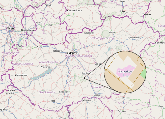
“Magyarkert”: A Hungary shaped park in Hungary, mapped from Bing aerial imagery. View it on openstreetmap: http://www.openstreetmap.org/?mlat=46.73825&mlon=19.58665&zoom=17&layers=M
Licensing
| Contains map data © OpenStreetMap contributors, made available under the terms of the Open Database License (ODbL).
The ODbL does not require any particular license for maps produced from ODbL data, produced maps may be subject also to other licences. |
Looks like it is openstreetmap osm carto tiles with some cut and paste work
This is a Featured image, which means that it has been identified as one of the best examples of OpenStreetMap mapping, or that it provides a useful illustration of the OpenStreetMap project. If you know another image of similar quality, you can nominate it on Featured image proposals.
Front-page image for week 15 of 2013 (8–14 Apr.).
- Image descriptions
- Deutsch : Magyarkert ("Ungarn-Garten") ist ein Erholungspark in Ungarn, der wie das Land im Maßstab 1:1000 geformt ist. Er enthält Flüsse, Seen und Hügelformen. Im Park geht es vor allem um Umweltschutz, Bildungsprogramme, Sport etc., und natürlich ist er in OpenStreetMap.
- English : Magyarkert ("HungarianGarden") is a leisure park in Hungary, shaped like the country at a 1:1000 size ratio. It includes main rivers, lakes and shapes of hills. The park's main theme is environment protection, educational programs, sport, etc, and of course it's on OpenStreetMap.
- español : Magyarkert ("Jardín Húngaro") es un parque de diversiones en Hungría, cuyo contorno imita el del país en una escala de 1:1 000. Incluye ríos, lagos y formas de cerros. Los principales objetivos del parque son la protección ambiental, programas educativos, y deportivos, entre otros, y por supuesto, está en OpenStreetMap.
- français : Magyarkert (« Jardin hongrois ») est un parc d'attraction en Hongrie, dont la forme est celle du pays à l'échelle 1:1000. Il comporte les principales cours d'eau, les lacs et les reliefs montagneux. Le thème principal du parc est la protection de l'environnement, les programmes éducatifs, le sport, etc... Et bien sur, il est représenté sur OpenStreetMap.
- italiano : Magyarkert ("GiardinoUngherese") è un parco di divertimenti in Ungheria, con la stessa forma del Paese in scala 1:1000. Comprende i fiumi principali, laghi e forme delle colline. Il tema principale del parco è la protezione dell'ambiente, programmi educativi, sport, ecc. e ovviamente è mappato in OpenStreetMap.
- Nederlands : Magyarkert ("HongarijePark") is een park in Hongarije met de vorm van dat land op een schaal van 1:1000. Het bevat de grote rivieren, meren en de vorm van heuvels. Het thema van het park is milieubescherming, educatie, sport enzovoorts, en natuurlijk vinden we het ook op OpenStreetMap.
- 中文(简体) : Magyarkert ("匈牙利花园")是匈牙利境内的休闲公园,其形状像是他们国土形状1:1000 的缩小比例。匈牙利公园包括河流、湖泊、以及山丘。公园设立目的主要是为了环境保境、环境教育、体育活动等,当然也包括开放街图。
- 中文(繁體) : Magyarkert ("匈牙利花園")是匈牙利境內的休閒公園,其形狀像是他們國土形狀 1:1000 的縮小比例。匈牙利公園包括河流、湖泊、以及山丘。公園設立目的主要是為了環境保境、環境教育、體育活動等,當然也包括開放街圖。
File history
Click on a date/time to view the file as it appeared at that time.
| Date/Time | Thumbnail | Dimensions | User | Comment | |
|---|---|---|---|---|---|
| current | 22:30, 28 March 2013 | | 654 × 472 (339 KB) | Kempelen (talk | contribs) | Magyarkert: Hungary shaped park in Hungary, mapped from Bing. |
You cannot overwrite this file.
File usage
The following 6 pages use this file: