File:Mapanalyst madrid.png
Jump to navigation
Jump to search


Size of this preview: 800 × 469 pixels. Other resolutions: 320 × 188 pixels | 640 × 375 pixels | 1,280 × 750 pixels.
Original file (1,280 × 750 pixels, file size: 803 KB, MIME type: image/png)
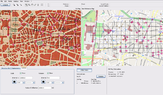
A screenshot of MapAnalyst [1] showing a 1890 map of Madrid alongside the openstreetmap reference map.
This is a Featured image, which means that it has been identified as one of the best examples of OpenStreetMap mapping, or that it provides a useful illustration of the OpenStreetMap project. If you know another image of similar quality, you can nominate it on Featured image proposals.
Front-page image for week 21 of 2009 (18–24 May).
- Image descriptions
- English : MapAnalyst is an open source tool for distortion analysis in old maps, that uses OSM as a the default reference cartography. (Shown here: 1:50k map of Madrid dated from 1875)
- italiano : MapAnalyst è uno strumento open source per l'analisi delle distorsioni nelle vecchie mappe, che usa OSM come cartografia predefinita di riferimento. (Nell'immagine: mappa 1:50k di Madrid nel 1875)
- magyar : A MapAnalyst egy nyílt forráskódú eszköz régi térképek torzításának elemzésére, amely az OSM-et használja, mint alapértelmezett referenciatérkép. (A képen látható: 1:50k méretarányú Madrid térkép 1875-ből)
- português : MapAnalyst é uma ferramenta de código aberto para análise de distorções em mapas antigos, que usa o OSM como referência cartográfica padrão. (Na imagem: mapa 1:50.000 de Madrid datado de 1875)
File history
Click on a date/time to view the file as it appeared at that time.
| Date/Time | Thumbnail | Dimensions | User | Comment | |
|---|---|---|---|---|---|
| current | 16:38, 1 May 2009 | | 1,280 × 750 (803 KB) | Ivansanchez (talk | contribs) | A screenshot of MapAnalyst [http://mapanalyst.cartography.ch/index.html] showing a 1890 map of Madrid alongside the openstreetmap reference map. |
You cannot overwrite this file.