File:Mapping in Senegal.jpeg
Jump to navigation
Jump to search


This image contains the identifiable likeness of one or more people who are known or presumed to be living.
Size of this preview: 800 × 600 pixels. Other resolutions: 320 × 240 pixels | 640 × 480 pixels | 1,024 × 768 pixels | 1,280 × 960 pixels | 2,560 × 1,920 pixels | 4,320 × 3,240 pixels.
Original file (4,320 × 3,240 pixels, file size: 4.67 MB, MIME type: image/jpeg)
Summary
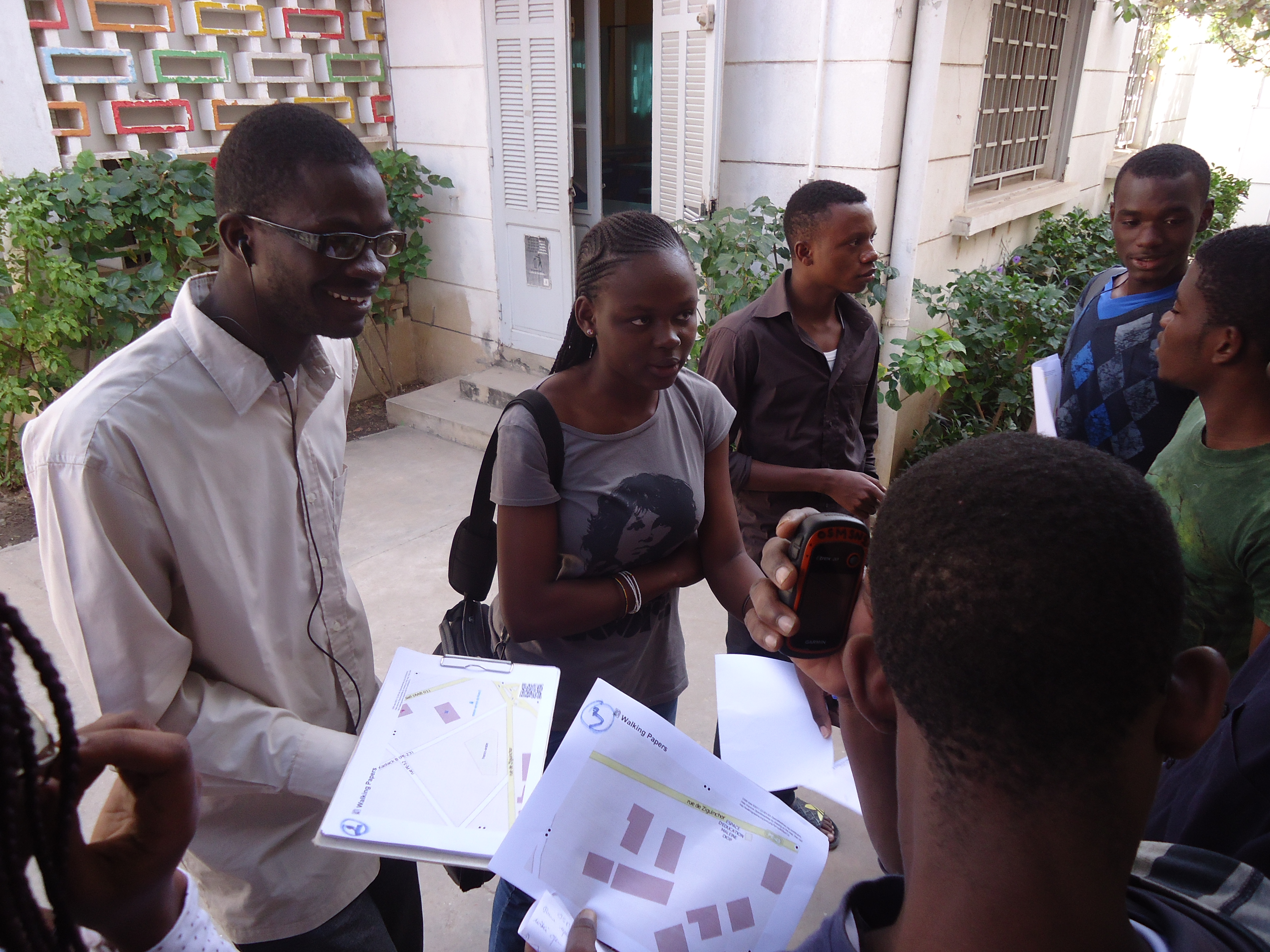
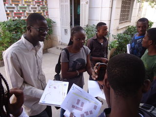
This photo shows architecture students of the Collège Universitaire d'Architecture of in Dakar, Senegal, during a training. In the foreground: Some Walking Papers printouts and a Garmin eTrex 20.
This is a Featured image, which means that it has been identified as one of the best examples of OpenStreetMap mapping, or that it provides a useful illustration of the OpenStreetMap project. If you know another image of similar quality, you can nominate it on Featured image proposals.
Front-page image for week 4 of 2014 (20–26 Jan.).
- Image descriptions
- Deutsch : Die OpenSteetMap-Gemeinschaft in Senegal wächstǃ Zurzeit finden viele Aktivitäten, Trainings und Präsentationen statt. Dieses Foto zeigt Architekturstudenten während einem Erkundungs/Survey-Training mit Walking-Papers-Ausdrucken und GPS-Geräten in Dakar.
- English : The OpenSteetMap community in Senegal is growingǃ A lot of activities, training and presentations are happening these days. This photo shows architecture students during a surveying training session with Walking Papers printouts and GPS devices in Dakar.
- español : La comunidad OpenSteetMap en Senegal esta creciendoǃ Muchas actividades, entrenamiento y presentaciones se han hecho en estos días. Esta foto muestra a los estudiantes de arquitectura durante una sesión de entrenamiento con mapas Walking Papers y dispositivos GPS en Dakar.
- français : La communauté d’OpenStreetMap au Sénégal grandi de plus en plus! Beaucoup d'activités, formations et présentations sont mises en place ces jours. Cette photo montre des étudiants en architecture pendant une formation sur le terrain avec des Walking Papers et des appareils GPS à Dakar.
- italiano : La comunità di OpenSteetMap in Senegal sta crescendoǃ Molte attività, formazione e presentazioni si stanno svolgendo in questo periodo. Questa foto mostra degli studenti di architettura durante una sessione di formazione sulla mappatura con stampe da Walking Papers e apparecchi GPS a Dakar.
- Nederlands : De OpenStreetMap gemeenschap in Senegal groeit! Vele activiteiten, trainingen en presentaties vinden deze dagen plaats. Op deze foto zijn architectuurstudenten aan de slag met Walking Papers en GPS-toestellen tijdens een training in Dakar.
- русский : Сообщество ОпенСтритМап в Сенегале становится всё больше; в эти дни там проходит множество мероприятий, в том числе тренинги и презентации. На фото студенты-архитекторы учатся собирать данные для карты с помощью обходных листов и записи GPS-треков.
- 中文(繁體) : 成長中的塞內加爾開放街圖社群!這陣子他們舉辦許多的活動、訓練課程和演講。這張照片顯示建築系學生在Dakar 一帶,使用 Walking Papers 和 GPS 裝置實地探察。
Licensing
![]()
This file has been released into the public domain by the copyright holder, its copyright has expired, or it is ineligible for copyright. This applies worldwide.
Please, please use more specific template such as {{PD-self}} / {{PD-creator}} / {{PD-shape}} / {{PD-USGov}} / {{PD-old}} / {{PD-RU-exempt}} ... This template is not making clear why this work is in the public domain.
Please, please use more specific template such as {{PD-self}} / {{PD-creator}} / {{PD-shape}} / {{PD-USGov}} / {{PD-old}} / {{PD-RU-exempt}} ... This template is not making clear why this work is in the public domain.
File history
Click on a date/time to view the file as it appeared at that time.
| Date/Time | Thumbnail | Dimensions | User | Comment | |
|---|---|---|---|---|---|
| current | 10:35, 19 January 2014 | | 4,320 × 3,240 (4.67 MB) | Jorieke (talk | contribs) | Training with students in architecture in Dakar, Senegal. |
You cannot overwrite this file.
File usage
The following 20 pages use this file:
- Cs:Přidejte se ke komunitě
- Data collection using preprinted map
- Fa:Join the community
- Featured images/Jan-Mar 2014
- Join the community
- List of featured images/2014
- Sv:Join the community
- Uk:Приєднуйтесь до спільноти
- Zh-hant:加入社群
- Talk:Featured images/Jul-Sep 2014
- Template:Iotw image/2014-4
- DE:Featured images/Jan-Mar 2014
- FR:Featured images/Jan-Mar 2014
- ES:Recopilación de datos usando mapa preimpreso
- ES:Unirse a la comunidad
- IT:Featured images/Jan-Mar 2014
- NL:Beginners Guide 1.0
- NL:Join the community
- RU:Присоединяйтесь к сообществу
- JA:コミュニティに参加する