File:Maxbe-stubaier-beschriftung en.png

Original file (820 × 780 pixels, file size: 343 KB, MIME type: image/png)
Summary
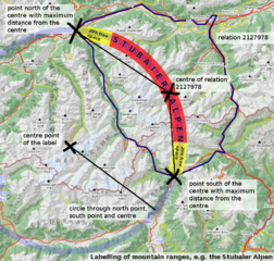
Illustration of how the labelling (capital letters, darkgrey-semitransparent) of mountain ranges, e.g. the Stubaier Alpen![]() Stubaier Alpen, could be done (rendered with mit geo.dianacht.de/topo, Data OpenStreetMap, hillshading data from ASTER, a product of METI and NASA). Shown position on the geo.dianacht.de/topo slippy map, description of the whole experimental map rendering project (German only, sorry).
Stubaier Alpen, could be done (rendered with mit geo.dianacht.de/topo, Data OpenStreetMap, hillshading data from ASTER, a product of METI and NASA). Shown position on the geo.dianacht.de/topo slippy map, description of the whole experimental map rendering project (German only, sorry).
Other versions: deutsche Version.
Description of the process
This is in an early, experimental state. The idea is based on this forum topic: http://forum.openstreetmap.org/viewtopic.php?id=16094
Some relations like name=Wetterstein;place=region;region:type=mountain_area;type=multipolygon (example relation![]() example relation) have been created in the OSM data (by Netzwolf).
example relation) have been created in the OSM data (by Netzwolf).
Process:
- determine the relation's boundary
- for all four main geographic directions: search the points on the boundary with maximum distance to the centroid of the relation's area
- search the two points with maximum distance from each other out of those four points (north-south or west-east; note that e.g. the west point could be identical to the north point)
- draw a circle through both points and through the centroid
- Construct a segment S1 of this circle: end points are the two points on the boundary.
- Make another segment S2 but with only 60 % of S1's length and centred on S1 (i.e. 20 % space on both ends)
- place the label's letters on the segment S2, with: the orientation of the letters depends on the position of segment S2 on the circle, the size of the letters depends on the length of segment S2.
Some more fiddling would be needed to also use this for sub-groups (e.g. one could replace “Wetterstein” and “Allgäuer Alpen” by the higher-level name “Alpen”) or for mountain ranges with exceptional shapes.
Licensing
Map data © OpenStreetMap Contributors,
![]()
![]()
![]()
Attribution not specified as a parameter! THIS LICENSE ALWAYS REQUIRES ATTRIBUTION! Use {{CC-BY-SA-2.0|Attribution, typically name of author}} See Template:CC-BY-SA-2.0 for full description how this template should be used.
Note, there is
{{CC-BY-SA-2.0 OpenStreetMap}} for files based on old OSM map data, before the license change made on 2012-09-12.There is also
{{OSM Carto screenshot||old_license}} for files based on old OSM map data, before the license change made on 2012-09-12, created using OSM Carto map style.
Featured image

Front-page image for week 29 of 2013 (15–21 Jul.).
- Image descriptions
- Deutsch : Große, gebogene Beschriftungen von Gebirgszügen. Die Illustration zeigt am Beispiel der Stubaier Alpen
 Stubaier Alpen, wie eine solche Beschriftung im automatischen Kartenerstellungsprozess (Rendering) basierend auf den rohen OpenStreetMap-Geodaten erstellt werden kann. Jene Beschriftungen zeigen grob die Größe und Form der beschrifteten Gebirgszüge und sind dennoch unaufdringlich. Gezeigte Position auf einer Slippy Map, Beschreibung des Verfahrens.
 - English : Large curved labels on a mountain range (Stubaier Alpen Stubaier Alpen shown here). The diagram illustrates how this cartographic effect could be achieved in an automated rendering process based on OpenStreetMap's raw geospatial data. Shown position on a slippy map, process description.
- español : Largas etiquetas curveadas en la cadena montañosa (Alpes del Stubai Alpes del Stubai mostradas aquí). La imagen muestra el efecto cartográfico en el proceso automático de renderizado basado en los datos geoespaciales de OpenStreetMap. Se muestra la posición en un Slippy Map, la descripción del proceso.
- français : Une illustration de la façon de faire des étiquettes des chaînes de montagnes (Alpes de Stubai Alpes de Stubai sur l'exemple) dans le processus de rendu d'une carte basée sur les données géospatiales brutes d'OpenStreetMap. Les étiquettes construites par cette méthode montre grossièrement la taille et la forme de la chaîne de montagne étiquetée de façon non obstructive. Position montrée sur une carte glissante, description de la construction.
- italiano : Grandi etichette curvate su una catena montuosa (Stubaier Alpen Stubaier Alpen mostrata qui). Il diagramma illustra come questo effetto cartografico può essere ottenuto in un processo di rendering automatico basato sui dati geospaziali grezzi di OpenStreetMap. Mostra la posizione su una slippy map, descrizione del procedimento (in inglese).
- Nederlands : Grote teksten op een cirkelboog in een berggebied (hier: de Stubaier Alpen Stubaier Alpen). Het diagram laat zien hoe dit kartografische effect kan worden bereikt bij een geautomatiseerd renderproces gebaseerd op OpenStreetMaps ruwe gegevens. De weergegeven positie op een grote kaart, een beschrijving van het proces.
- русский : Диаграмма иллюстрирует алгоритм нанесения крупных подписей к горным хребтам в автоматическом режиме. См. интерактивную карту и описание процесса. На примере — Штубайские Альпы Штубайские Альпы.
- 中文(简体) : 用湾曲的大标签标示山脉(这边显示山斯图拜阿尔卑斯山脉 山斯图拜阿尔卑斯山脉)。这张图片显示制图效果能够怎么用开放街图的原始地理空间资料自动化渲染达成。 位置显示在互动地图上, 制作叙述。
- 中文(繁體) : 用灣曲的大標籤標示山脈(這邊顯示山斯圖拜阿爾卑斯山脈 山斯圖拜阿爾卑斯山脈)。這張圖片顯示製圖效果能夠怎麼用開放街圖的原始地理空間資料自動化渲染達成。位置顯示在互動地圖上, 製作敘述。
File history
Click on a date/time to view the file as it appeared at that time.
| Date/Time | Thumbnail | Dimensions | User | Comment | |
|---|---|---|---|---|---|
| current | 15:38, 11 July 2013 | | 820 × 780 (343 KB) | Maxbe (talk | contribs) | Typo and american to british english |
| 15:19, 9 July 2013 |  | 820 × 780 (343 KB) | Maxbe (talk | contribs) | Labeling of mountain regions, e.g. the {{relation|tools=no|2127978|Stubaier Alpen}} (rendered with mit geo.dianacht.de/topo, Data [http://www.openstreetmap.org/copyright OpenStreetMap], Hillshading data from ASTER, a produkt of METI and NASA). [[User:M... |
You cannot overwrite this file.
File usage
The following 5 pages use this file: