File:Maxbe saettel aus hwerten 2.png
Jump to navigation
Jump to search

No higher resolution available.
Maxbe_saettel_aus_hwerten_2.png (400 × 400 pixels, file size: 59 KB, MIME type: image/png)
Summary
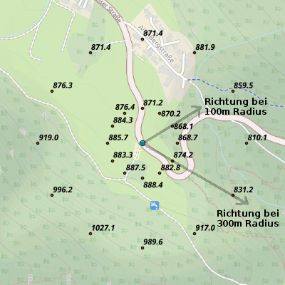
Bestimmung der Richtung eines Sattels aus Höhrnlinien. Bild: openstreetmap.org / opencyclemap Höhendaten: viewfinderpanoramas.org
Licensing
![]()
![]()
![]()
This work is licensed under the Creative Commons Attribution-ShareAlike 3.0 License.
Attribution not specified as a parameter! THIS LICENSE ALWAYS REQUIRES ATTRIBUTION! Use {{CC-BY-SA-3.0|Attribution, typically name of author}} See Template:CC-BY-SA-3.0 for full description how this template should be used.
Attribution not specified as a parameter! THIS LICENSE ALWAYS REQUIRES ATTRIBUTION! Use {{CC-BY-SA-3.0|Attribution, typically name of author}} See Template:CC-BY-SA-3.0 for full description how this template should be used.
File history
Click on a date/time to view the file as it appeared at that time.
| Date/Time | Thumbnail | Dimensions | User | Comment | |
|---|---|---|---|---|---|
| current | 22:10, 21 January 2017 | | 400 × 400 (59 KB) | Maxbe (talk | contribs) | Bestimmung der Richtung eines Sattels aus Höhrnlinien. Bild: openstreetmap.org / opencyclemap Höhendaten: viewfinderpanoramas.org |
You cannot overwrite this file.
File usage
The following page uses this file: