File:Menhir du Champ Dolent.jpg
Jump to navigation
Jump to search


Size of this preview: 400 × 600 pixels. Other resolutions: 160 × 240 pixels | 320 × 480 pixels | 512 × 768 pixels | 682 × 1,024 pixels | 1,365 × 2,048 pixels | 2,600 × 3,900 pixels.
Original file (2,600 × 3,900 pixels, file size: 6.32 MB, MIME type: image/jpeg)
This file and its description are from Wikimedia Commons.
Summary
| Description |
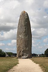
English: The Menhir de Champ-Dolent, largest menhir in Brittany (Size 10 m).
Français : Le Menhir de Champ-Dolent, le plus grand de Bretagne (Taille 10 m). |
|
| Date | ||
| Source | Own work | |
| Author |
| |
| Attribution (required by the license) | © Guillaume Piolle / | |
| Camera location | | View this and other nearby images on: OpenStreetMap |
|---|
|


|
This image has been assessed under the valued image criteria and is considered the most valued image on Commons within the scope: Menhir du Champ Dolent (Dol-de-Bretagne, France). You can see its nomination here. |
| This is a retouched picture, which means that it has been digitally altered from its original version. Modifications: tourist removed, wires removed, levels adjusted, sharpened.
|
Licensing
I, the copyright holder of this work, hereby publish it under the following licenses:

|
Permission is granted to copy, distribute and/or modify this document under the terms of the GNU Free Documentation License, Version 1.2 or any later version published by the Free Software Foundation; with no Invariant Sections, no Front-Cover Texts, and no Back-Cover Texts. A copy of the license is included in the section entitled GNU Free Documentation License. |
This file is licensed under the Creative Commons Attribution 3.0 Unported license.
- You are free:
- to share – to copy, distribute and transmit the work
- to remix – to adapt the work
- Under the following conditions:
- attribution – You must give appropriate credit, provide a link to the license, and indicate if changes were made. You may do so in any reasonable manner, but not in any way that suggests the licensor endorses you or your use.
You may select the license of your choice.
File history
Click on a date/time to view the file as it appeared at that time.
| Date/Time | Thumbnail | Dimensions | User | Comment | |
|---|---|---|---|---|---|
| current | 12:38, 15 August 2010 | | 2,600 × 3,900 (6.32 MB) | wikimediacommons>Eusebius | {{Information |Description={{en|1=The {{w|Menhir de Champ-Dolent}}, largest menhir in Brittany.}} {{fr|1=Le Menhir de Champ-Dolent, le plus grand {{Location|48|33|01.71|N|1|45|24.61|W|heading:ENE}} {{retouched|perspective co |
File usage
The following 11 pages use this file:
- Cs:Key:megalith type
- Historical Objects/Map Properties
- Key:megalith type
- Pl:Historical Objects/Map Properties
- Pl:Key:megalith type
- Pt:Historical Objects/Características do mapa
- DE:Historical Objects/Karteneigenschaften
- DE:Key:megalith type
- FR:Historical Objects/Attributs
- RU:Исторические объекты/Свойства карты
- JA:Historical Objects/Map Properties