File:Milton Keynes Sector.jpg
Jump to navigation
Jump to search
No higher resolution available.
Milton_Keynes_Sector.jpg (534 × 528 pixels, file size: 467 KB, MIME type: image/jpeg)
This file and its description are from Wikimedia Commons.

|
This city map image could be re-created using vector graphics as an SVG file. This has several advantages; see Commons:Media for cleanup for more information. If an SVG form of this image is available, please upload it and afterwards replace this template with
{{vector version available|new image name}}.
It is recommended to name the SVG file “Milton Keynes Sector.svg”—then the template Vector version available (or Vva) does not need the new image name parameter. |


Summary
| Description |
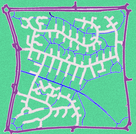
English: One sector (Heelands) of the Milton Keynes town that is enclosed by the 1 km grid of main roads. The road network within the sector uses cul-de-sac streets complemented by foot and bike paths. |
| Date | |
| Source | Own work |
| Author | Fgrammen |
Licensing
| I, the copyright holder of this work, release this work into the public domain. This applies worldwide. In some countries this may not be legally possible; if so: I grant anyone the right to use this work for any purpose, without any conditions, unless such conditions are required by law. |
File history
Click on a date/time to view the file as it appeared at that time.
| Date/Time | Thumbnail | Dimensions | User | Comment | |
|---|---|---|---|---|---|
| current | 15:28, 8 June 2010 | | 534 × 528 (467 KB) | wikimediacommons>Fgrammen | {{Information |Description={{en|1=One sector of the Milton Keynes town that is enclosed by the 1 km grid of main roads. The road network within the sector uses cul-de-sac streets complemented by foot and bike paths.}} |Source={{own}} |Author=[[User:Fgramm |
File usage
There are no pages that use this file.